Category:Rietschen, Görlitzer Straße 24, 24b
Jump to navigation
Jump to search
| Object location | | View all coordinates using: OpenStreetMap |
|---|
villa in Rietschen, Germany .jpg) | |||||
| Upload media | |||||
| Instance of | |||||
|---|---|---|---|---|---|
| Location | Rietschen, Görlitz, Saxony, Germany | ||||
| Street address |
| ||||
| Heritage designation | |||||
 | |||||
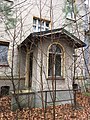
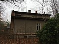
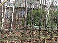
Deutsch: Villa aus den 1920er Jahren mit Einfriedung; in Rietschen, Görlitzer Straße 24/24b; baugeschichtlich von Bedeutung; Kulturdenkmal
English: Mansion from the 1920s with fencing in Rietschen, Görlitzer Straße 24/24b; of importance of construction and urban development; cultural heritage monument
| (Wikidata) |
Media in category "Rietschen, Görlitzer Straße 24, 24b"
The following 36 files are in this category, out of 36 total.
-
 Rietschen, Görlitzer Straße 24 (01).jpg 4,032 × 3,024; 4.1 MB
-
 Rietschen, Görlitzer Straße 24 (02).jpg 4,032 × 3,024; 4.89 MB
-
 Rietschen, Görlitzer Straße 24 (03).jpg 4,032 × 3,024; 5.28 MB
-
 Rietschen, Görlitzer Straße 24 (04).jpg 3,024 × 4,032; 3.62 MB
-
 Rietschen, Görlitzer Straße 24 (05).jpg 4,032 × 3,024; 4.4 MB
-
 Rietschen, Görlitzer Straße 24 (06).jpg 3,024 × 4,032; 4.02 MB
-
 Rietschen, Görlitzer Straße 24 (07).jpg 4,032 × 3,024; 4.38 MB
-
 Rietschen, Görlitzer Straße 24 (08).jpg 3,024 × 4,032; 3.87 MB
-
 Rietschen, Görlitzer Straße 24 (09).jpg 4,032 × 3,024; 4.58 MB
-
 Rietschen, Görlitzer Straße 24 (10).jpg 4,032 × 3,024; 4.8 MB
-
 Rietschen, Görlitzer Straße 24 (11).jpg 4,032 × 3,024; 3.99 MB
-
 Rietschen, Görlitzer Straße 24 (12).jpg 3,024 × 4,032; 4.35 MB
-
 Rietschen, Görlitzer Straße 24 (13).jpg 4,032 × 3,024; 3.91 MB
-
 Rietschen, Görlitzer Straße 24 (14).jpg 3,024 × 4,032; 4.31 MB
-
 Rietschen, Görlitzer Straße 24 (15).jpg 4,032 × 3,024; 4.34 MB
-
 Rietschen, Görlitzer Straße 24 (16).jpg 3,024 × 4,032; 3.91 MB
-
 Rietschen, Görlitzer Straße 24 (17).jpg 3,024 × 4,032; 4.04 MB
-
 Rietschen, Görlitzer Straße 24 (18).jpg 4,032 × 3,024; 3.5 MB
-
 Rietschen, Görlitzer Straße 24 (19).jpg 4,032 × 3,024; 2.99 MB
-
 Rietschen, Görlitzer Straße 24 (20).jpg 4,032 × 3,024; 4.17 MB
-
 Rietschen, Görlitzer Straße 24 (21).jpg 4,032 × 3,024; 5.39 MB
-
 Rietschen, Görlitzer Straße 24 (22).jpg 4,032 × 3,024; 4.8 MB
-
 Rietschen, Görlitzer Straße 24 (23).jpg 4,032 × 3,024; 4.94 MB
-
 Rietschen, Görlitzer Straße 24 (24).jpg 4,032 × 3,024; 4.78 MB
-
 Rietschen, Görlitzer Straße 24 (25).jpg 3,024 × 4,032; 3.61 MB
-
 Rietschen, Görlitzer Straße 24 (26).jpg 3,024 × 4,032; 2.64 MB
-
 Rietschen, Görlitzer Straße 24 (27).jpg 4,032 × 3,024; 4.37 MB
-
 Rietschen, Görlitzer Straße 24 (28).jpg 4,032 × 3,024; 4 MB
-
 Rietschen, Görlitzer Straße 24 (29).jpg 4,032 × 3,024; 4.73 MB
-
 Rietschen, Görlitzer Straße 24 (30).jpg 4,032 × 3,024; 5.02 MB
-
 Rietschen, Görlitzer Straße 24 (31).jpg 4,032 × 3,024; 5.15 MB
-
 Rietschen, Görlitzer Straße 24 (32).jpg 4,032 × 3,024; 5.25 MB
-
 Rietschen, Görlitzer Straße 24 (33).jpg 4,032 × 3,024; 4.88 MB
-
 Rietschen, Görlitzer Straße 24 (34).jpg 4,032 × 3,024; 4.94 MB
-
 Rietschen, Görlitzer Straße 24 (35).jpg 4,032 × 3,024; 4.3 MB
-
 Rietschen, Görlitzer Straße 24 (36).jpg 4,032 × 3,024; 4.52 MB
.jpg)
.jpg)
.jpg)
.jpg)
.jpg)
.jpg)
.jpg)
.jpg)
.jpg)
.jpg)
.jpg)
.jpg)
.jpg)
.jpg)
.jpg)
.jpg)
.jpg)
.jpg)
.jpg)
.jpg)
.jpg)
.jpg)
.jpg)
.jpg)
.jpg)
.jpg)
.jpg)
.jpg)
.jpg)
.jpg)
.jpg)
.jpg)
.jpg)
.jpg)
.jpg)