Category:SVG labeled maps of administrative divisions of the United Kingdom (location map scheme) (german)
Jump to navigation
Jump to search


.svg)


_(Paris_zoom).svg)
.svg)
,_administrative_divisions_-_de_-_colored_(multizoom).svg)
_-_colored.svg)
.svg)
,_administrative_divisions_-_Nmbrs_(multizoom).svg)
,_administrative_divisions_-_de_-_colored.svg)
_-_de_-_colored.svg)

.svg)

.svg)
Media in category "SVG labeled maps of administrative divisions of the United Kingdom (location map scheme) (german)"
The following 39 files are in this category, out of 39 total.
-
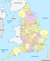 England, administrative divisions (admin counties) - de - colored.svg 816 × 991; 1.48 MB
-
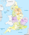
 England, administrative divisions (admin counties) - de - monochrome.svg 816 × 991; 1.49 MB
-
-

-

-

-

-

-

-

-
-

-

-

-

-

-
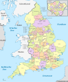
 England, administrative divisions - de - colored.svg 816 × 991; 715 KB
-
 England, administrative divisions - de - monochrome.svg 816 × 991; 722 KB
-
 Greater London, administrative divisions - de - colored.svg 1,425 × 1,140; 1.24 MB
-
 Greater London, administrative divisions - de - monochrome.svg 1,425 × 1,140; 1.24 MB
-
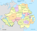 Northern Ireland, administrative divisions - de - colored.svg 1,208 × 1,027; 344 KB
-
 Northern Ireland, administrative divisions - de - monochrome.svg 1,208 × 1,027; 345 KB
-
 Scotland, administrative divisions - de - colored (zoom).svg 1,128 × 1,483; 1.41 MB
-
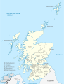
 Scotland, administrative divisions - de - colored.svg 1,128 × 1,483; 1.15 MB
-
 Scotland, administrative divisions - de - monochrome (zoom).svg 1,128 × 1,483; 1.4 MB
-
 Scotland, administrative divisions - de - monochrome.svg 1,128 × 1,483; 1.14 MB
-
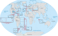
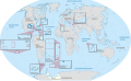
 United Kingdom (overseas+crown dependencies), administrative divisions - de (marker).svg 3,188 × 1,964; 5.79 MB
-

-
-
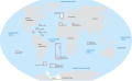 United Kingdom (overseas-crown dependencies), administrative divisions - de (marker).svg 3,188 × 1,964; 5.8 MB
-
-
-
 United Kingdom, administrative divisions - de - colored, Noto font.svg 886 × 1,369; 1.86 MB
-
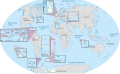
 United Kingdom, administrative divisions - de - colored.svg 886 × 1,369; 2.96 MB
-
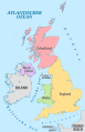
 United Kingdom, administrative divisions - de.svg 886 × 1,369; 2.38 MB
-
 Wales, administrative divisions (preserved counties) - de - colored.svg 1,047 × 1,252; 251 KB
-
 Wales, administrative divisions (preserved counties) - de - monochrome.svg 1,047 × 1,252; 252 KB
-
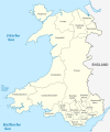
 Wales, administrative divisions - de - colored.svg 1,047 × 1,252; 377 KB
-
 Wales, administrative divisions - de - monochrome.svg 1,047 × 1,252; 378 KB
_-_de_-_colored.svg)
_-_de_-_monochrome.svg)
_-_de_-_colored_(%2BLondon_zoom).svg)
_-_de_-_colored.svg)
_-_de_-_monochrome_(%2BLondon_zoom).svg)
_-_de_-_monochrome.svg)
_-_de_-_colored_(%2BLondon_zoom).svg)
_-_de_-_colored_(-London_zoom).svg)
_-_de_-_monochrome_(%2BLondon_zoom).svg)
_-_de_-_monochrome_(-London_zoom).svg)
_-_de_-_colored.svg)
_-_de_-_monochrome.svg)
_-_de_-_colored_(%2BLondon_zoom).svg)
_-_de_-_colored_(-London_zoom).svg)
_-_de_-_monochrome_(%2BLondon_zoom).svg)
_-_de_-_monochrome_(-London_zoom).svg)


.svg)

.svg)

,_administrative_divisions_-_de_(marker).svg)
,_administrative_divisions_-_de_(multiple_zoom).svg)
,_administrative_divisions_-_de_(single_zoom).svg)
,_administrative_divisions_-_de_(marker).svg)
,_administrative_divisions_-_de_(multiple_zoom).svg)
,_administrative_divisions_-_de_(single_zoom).svg)


_-_de_-_colored.svg)
_-_de_-_monochrome.svg)

