Category:SVG locator maps of provinces in the Netherlands (location map scheme)
Jump to navigation
Jump to search

|
SVG maps in this category are part of a locator map series applying the (de) widespread location map scheme. Please see root category to browse for more. |
.svg)
.svg)
.svg)
.svg)
.svg)
.svg)
.svg)
Locator maps design recommendations ▼ | |
|---|---|
Principles
Design Guidelines are based on ▸location map design of the German map shop (in German). It's preferable to derive new locator maps from existing location maps. Please keep both size and ratio in this case. Thus the new locator maps may still be applied as location map (▸Guide). Marker color is supposed to be darkred. Waterbodies may be transparent, to show other objects better. Please be aware that this guide is only a recommendation. It’s not an inevitable law!
Highlight small areas
“Remote” areas and mini maps
Mini maps show where the depicted area actually is situated. Check out ▸Vorlage:Positionskarte+ (in German) and ▸Modèle:Carte en coin (in French) of how to insert a mini map in virtually every map.
Disputed areas
Greyed special objects
Backgrounds
|

-en.svg)

.svg)
.svg)
.svg)

_(US48).svg)
_(small_islands_magnified)_(-mini_map_-rivers).svg)
.svg)
_(extra_close)_(US48).svg)
.svg)
_(zoom).svg)

.svg)


_(UNMIK).svg)
.svg)
_(disputed_hatched).svg)
_(claimed_and_disputed_hatched).svg)
.svg)
.svg)
_(%2Ball_claims_hatched).svg)

.svg)
_(shade).svg)
_(shade)_(special_marker).svg)
_(-mini_map).svg)
_(-mini_map).svg)
_(-mini_map).svg)


.svg)

.svg)
Media in category "SVG locator maps of provinces in the Netherlands (location map scheme)"
The following 24 files are in this category, out of 24 total.
-
 Drenthe in the Netherlands 2019.svg 888 × 1,001; 160 KB
-
 Drenthe in the Netherlands.svg 888 × 1,001; 143 KB
-
 Flevoland in the Netherlands 2019.svg 888 × 1,001; 160 KB
-
 Flevoland in the Netherlands.svg 888 × 1,001; 143 KB
-
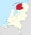
 Friesland in the Netherlands 2019.svg 888 × 1,001; 160 KB
-
 Friesland in the Netherlands.svg 888 × 1,001; 147 KB
-
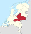
 Gelderland in the Netherlands 2019.svg 888 × 1,001; 160 KB
-
 Gelderland in the Netherlands.svg 888 × 1,001; 148 KB
-
 Groningen in the Netherlands 2019.svg 888 × 1,001; 160 KB
-
 Groningen in the Netherlands.svg 888 × 1,001; 145 KB
-
 Limburg in the Netherlands 2019.svg 888 × 1,001; 160 KB
-
 Limburg in the Netherlands.svg 888 × 1,001; 146 KB
-
 Noord-Brabant in the Netherlands 2019.svg 888 × 1,001; 160 KB
-
 Noord-Brabant in the Netherlands.svg 888 × 1,001; 146 KB
-
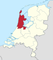 Noord-Holland in the Netherlands 2019.svg 888 × 1,001; 160 KB
-
 Noord-Holland in the Netherlands.svg 888 × 1,001; 146 KB
-
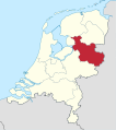 Overijssel in the Netherlands 2019.svg 888 × 1,001; 160 KB
-
 Overijssel in the Netherlands.svg 888 × 1,001; 145 KB
-
 Utrecht in the Netherlands 2019.svg 888 × 1,001; 160 KB
-
 Utrecht in the Netherlands.svg 888 × 1,001; 143 KB
-
 Zeeland in the Netherlands 2019.svg 888 × 1,001; 160 KB
-
 Zeeland in the Netherlands.svg 888 × 1,001; 150 KB
-
 Zuid-Holland in the Netherlands 2019.svg 888 × 1,001; 160 KB
-
 Zuid-Holland in the Netherlands.svg 888 × 1,001; 147 KB


