Category:Schlachthof (Stauffacherstrasse 80, 80a, 82, Bern)
Jump to navigation
Jump to search
| Object location | | View all coordinates using: OpenStreetMap |
|---|
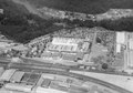
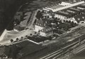
architectural ensemble with former administration and service buildings of the abattoir in the city of Bern, Switzerland.  Schlachthof-Gebäude unten links im Bild (1918 / 1937) | |||||
| Upload media | |||||
| Instance of | |||||
|---|---|---|---|---|---|
| Part of |
| ||||
| Location | Breitfeld, Breitenrain-Lorraine, Bern, Bern-Mittelland administrative district, Bernese Mittelland administrative region, Bern, Switzerland | ||||
| Street address |
| ||||
| Heritage designation |
| ||||
| Inception |
| ||||
 | |||||
Media in category "Schlachthof (Stauffacherstrasse 80, 80a, 82, Bern)"
The following 4 files are in this category, out of 4 total.
-
 ETH-BIB-Bern, Schlachthof-LBS H1-028390.tif 6,610 × 4,611; 87.26 MB
-
 ETH-BIB-Bern-Wiler, Industriegebiet-Inlandflüge-LBS MH03-1482.tif 6,405 × 4,515; 82.87 MB
-
 ETH-BIB-Bern-Wilerfeld, Schlachthof Bern-Inlandflüge-LBS MH03-1558 (cropped).tif 3,489 × 2,453; 24.51 MB
-
 ETH-BIB-Bern-Wilerfeld, Schlachthof Bern-Inlandflüge-LBS MH03-1558.tif 6,370 × 4,476; 81.69 MB