Category:Shotley
Jump to navigation
Jump to search
This is a disambiguation – a navigational aid which lists categories that might otherwise share the same name.
This category page should not hold any files. See also: Special:Categories/Shotley, Special:PrefixIndex/Category:Shotley, Wikidata or categories with "Shotley" in name |
|
Wikimedia disambiguation page | |||||
| Instance of | |||||
|---|---|---|---|---|---|
| |||||
Shotley may refer to:
Media in category "Shotley"
The following 100 files are in this category, out of 100 total.
-
 2016, a year on Geograph (Day 366) - geograph.org.uk - 5240137.jpg 640 × 480; 56 KB
-
 Approaching Shotley Church End from the south - geograph.org.uk - 6096947.jpg 5,266 × 3,510; 4.55 MB
-
 Babergh navigation buoy, River Orwell - geograph.org.uk - 5498094.jpg 1,024 × 615; 123 KB
-
 Barns at Old Hall, Shotley - geograph.org.uk - 6097000.jpg 6,000 × 4,000; 6.46 MB
-
 Boat on the mud - geograph.org.uk - 5917625.jpg 4,000 × 3,000; 4.55 MB
-
 Boats on the Orwell - geograph.org.uk - 5106275.jpg 3,059 × 1,529; 859 KB
-

-
 Brickkiln Terrace, Wade's Lane - geograph.org.uk - 6092856.jpg 6,000 × 4,000; 6.22 MB
-
 Buoys on the River Orwell - geograph.org.uk - 5369397.jpg 640 × 480; 256 KB
-

-

-
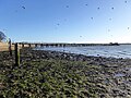
 Chelmondiston Marshes at Colton Creek - geograph.org.uk - 5497505.jpg 1,024 × 768; 127 KB
-
 Church Walk - geograph.org.uk - 5611405.jpg 640 × 480; 240 KB
-
 Church Walk - geograph.org.uk - 5611409.jpg 640 × 480; 123 KB
-

-
 Cranes on Felixstowe Docks from Shotley - geograph.org.uk - 5318781.jpg 3,436 × 1,303; 1.24 MB
-
 Dinghy on the River Orwell - geograph.org.uk - 5369517.jpg 640 × 480; 210 KB
-
 Drainage channel near the Orwell - geograph.org.uk - 5917641.jpg 4,000 × 3,000; 4.79 MB
-
 Driveway to Shotley Hall - geograph.org.uk - 6092863.jpg 6,000 × 4,000; 6.35 MB
-
 Edwarton Bay - geograph.org.uk - 5530447.jpg 1,024 × 768; 217 KB
-
 Entrance to Crane's Creek, below Crane's Hill - geograph.org.uk - 5498120.jpg 1,024 × 614; 144 KB
-
 Fagbury navigation buoy, River Orwell - geograph.org.uk - 5502785.jpg 1,024 × 768; 113 KB
-
 Farm track descending onto Shotley Marshes - geograph.org.uk - 6097071.jpg 6,000 × 4,000; 6.59 MB
-

-
 Felixstowe , container terminal - geograph.org.uk - 6157956.jpg 1,024 × 594; 461 KB
-
 Felixstowe Container port - geograph.org.uk - 5370552.jpg 640 × 481; 244 KB
-
 Felixstowe Container port - geograph.org.uk - 5371275.jpg 640 × 480; 241 KB
-
 Felixstowe Container port - geograph.org.uk - 5371276.jpg 640 × 480; 249 KB
-
 Felixstowe Container port - geograph.org.uk - 5371277.jpg 640 × 480; 269 KB
-
 Felixstowe Container port - geograph.org.uk - 5371279.jpg 640 × 480; 245 KB
-
 Felixstowe Container port - geograph.org.uk - 5371295.jpg 640 × 480; 203 KB
-
 Felixstowe Port - geograph.org.uk - 5071272.jpg 2,592 × 1,944; 522 KB
-
 Gated track down to Shotley Marshes - geograph.org.uk - 5611487.jpg 640 × 480; 156 KB
-
 Harwich , view from Shotley Marina - geograph.org.uk - 6158934.jpg 1,024 × 627; 551 KB
-
 High tide in the Stour estuary - geograph.org.uk - 6097139.jpg 5,833 × 3,889; 3.53 MB
-
 HMS Ganges at Shotley - geograph.org.uk - 5369365.jpg 640 × 480; 252 KB
-
 HMS Ganges at Shotley - geograph.org.uk - 5369377.jpg 640 × 480; 234 KB
-
 HMS Ganges at Shotley - geograph.org.uk - 5369387.jpg 640 × 480; 263 KB
-
 Inside St Mary, Shotley (i) - geograph.org.uk - 5247463.jpg 480 × 640; 39 KB
-
 Inside St Mary, Shotley (ii) - geograph.org.uk - 5247464.jpg 640 × 480; 45 KB
-
 Inside St Mary, Shotley (ii) - geograph.org.uk - 5247469.jpg 640 × 480; 38 KB
-
 Inside St Mary, Shotley (iii) - geograph.org.uk - 5247470.jpg 640 × 480; 50 KB
-
 Inside St Mary, Shotley (iv) - geograph.org.uk - 5247472.jpg 640 × 480; 57 KB
-
 Inside St Mary, Shotley (ix) - geograph.org.uk - 5247483.jpg 480 × 640; 43 KB
-
 Inside St Mary, Shotley (v) - geograph.org.uk - 5247474.jpg 640 × 480; 41 KB
-
 Inside St Mary, Shotley (vi) - geograph.org.uk - 5247476.jpg 640 × 480; 54 KB
-
 Inside St Mary, Shotley (vii) - geograph.org.uk - 5247477.jpg 640 × 480; 51 KB
-
 Inside St Mary, Shotley (viii) - geograph.org.uk - 5247482.jpg 480 × 640; 61 KB
-
 Inside St Mary, Shotley (xi) - geograph.org.uk - 5247484.jpg 480 × 640; 47 KB
-
 Inside St Mary, Shotley (xii) - geograph.org.uk - 5247485.jpg 480 × 640; 57 KB
-
 Inside St Mary, Shotley (xiii) - geograph.org.uk - 5247488.jpg 480 × 640; 43 KB
-
 Inside St Mary, Shotley (xiv) - geograph.org.uk - 5247490.jpg 480 × 640; 43 KB
-
 Inside St Mary, Shotley (xix) - geograph.org.uk - 5247496.jpg 480 × 640; 67 KB
-
 Inside St Mary, Shotley (xv) - geograph.org.uk - 5247492.jpg 480 × 640; 29 KB
-
 Inside St Mary, Shotley (xvi) - geograph.org.uk - 5247493.jpg 480 × 640; 42 KB
-
 Inside St Mary, Shotley (xvii) - geograph.org.uk - 5247494.jpg 480 × 640; 35 KB
-
 Inside St Mary, Shotley (xx) - geograph.org.uk - 5247497.jpg 480 × 640; 62 KB
-
 Irrigation reservoir below Charity Farm - geograph.org.uk - 6092877.jpg 6,000 × 4,000; 6.66 MB
-
 Lightship moored in Harwich Harbour - geograph.org.uk - 6097241.jpg 5,753 × 3,835; 2.07 MB
-
 Man's Cliff, from the north - geograph.org.uk - 5497453.jpg 1,024 × 768; 149 KB
-
 Map of Shotley, OS 1946.png 333 × 231; 133 KB
-
 Orwell navigation buoy, River Orwell - geograph.org.uk - 5498104.jpg 1,024 × 615; 103 KB
-

-

-
-
 Ross Farm Cottages - geograph.org.uk - 5369303.jpg 640 × 480; 203 KB
-
 Saltmarsh near Cranes Hill - geograph.org.uk - 5917632.jpg 4,000 × 3,000; 4.96 MB
-
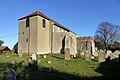 Shotley church - geograph.org.uk - 5611419.jpg 640 × 428; 100 KB
-
 Shotley Marina , HMS Ganges Museum - geograph.org.uk - 6157943.jpg 1,024 × 625; 493 KB
-
 Shotley Marina - geograph.org.uk - 5370509.jpg 640 × 480; 211 KB
-
 Shotley Marina - geograph.org.uk - 5370514.jpg 640 × 480; 211 KB
-
 Shotley Marina control tower - geograph.org.uk - 5611591.jpg 640 × 480; 101 KB
-
 Shotley Pier - geograph.org.uk - 5611584.jpg 640 × 480; 149 KB
-
 Shotley Point Marina Landing - geograph.org.uk - 6097123.jpg 6,000 × 4,000; 6.23 MB
-
 St Mary, Shotley, banner - geograph.org.uk - 5247499.jpg 480 × 640; 47 KB
-
 St Mary, Shotley, churchyard (i) - geograph.org.uk - 5247453.jpg 640 × 480; 61 KB
-
 St Mary, Shotley, churchyard (ii) - geograph.org.uk - 5247455.jpg 640 × 480; 55 KB
-
 St Mary, Shotley, churchyard (iii) - geograph.org.uk - 5247456.jpg 640 × 480; 57 KB
-
 St Mary, Shotley, churchyard (iv) - geograph.org.uk - 5247458.jpg 640 × 480; 82 KB
-
 St Mary, Shotley, churchyard (v) - geograph.org.uk - 5247460.jpg 640 × 480; 55 KB
-
 St Mary, Shotley, font - geograph.org.uk - 5247467.jpg 480 × 640; 37 KB
-
 St Mary, Shotley, late December 2016 - geograph.org.uk - 5247450.jpg 640 × 480; 73 KB
-
 St Mary, Shotley, memorial (i) - geograph.org.uk - 5247473.jpg 640 × 480; 59 KB
-
 St Mary, Shotley, memorial (ii) - geograph.org.uk - 5247475.jpg 640 × 480; 43 KB
-

-
 St Mary, Shotley, war memorial - geograph.org.uk - 5247498.jpg 480 × 640; 50 KB
-
 The Bristol Arms, Shotley - geograph.org.uk - 5318776.jpg 3,456 × 2,592; 3.82 MB
-
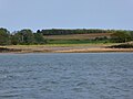
 The River Orwell at Colton Creek - geograph.org.uk - 5497491.jpg 1,024 × 614; 115 KB
-

-
 The sign of The Bristol Arms at Shotley - geograph.org.uk - 5318778.jpg 2,592 × 3,456; 2.99 MB
-
 Trimley lagoon - geograph.org.uk - 5371345.jpg 640 × 480; 222 KB
-
 Trinity container terminal, Port of Felixstowe - geograph.org.uk - 5502789.jpg 1,024 × 768; 116 KB
-
 Upstream end of Felixstowe wharfage - geograph.org.uk - 5611623.jpg 640 × 480; 102 KB
-
 Victorian V R Postbox (disused) - geograph.org.uk - 5318772.jpg 2,592 × 3,456; 3.22 MB
-
 View east from East View Terrace - geograph.org.uk - 6097166.jpg 6,000 × 4,000; 5.95 MB
-
 View from Oldhall Hill, Shotley - geograph.org.uk - 6096922.jpg 6,000 × 4,000; 6.33 MB
-
 View towards the River Orwell from Wade's Lane - geograph.org.uk - 6092874.jpg 6,000 × 4,000; 6.63 MB
-
 View towards the River Orwell from Wade's Lane - geograph.org.uk - 6092882.jpg 6,000 × 4,000; 6.71 MB
-
 Water tower on top of Martello Tower M - geograph.org.uk - 5917613.jpg 3,000 × 4,000; 4.32 MB
-

_-_geograph.org.uk_-_5240137.jpg)


_-_geograph.org.uk_-_5247463.jpg)
_-_geograph.org.uk_-_5247464.jpg)
_-_geograph.org.uk_-_5247469.jpg)
_-_geograph.org.uk_-_5247470.jpg)
_-_geograph.org.uk_-_5247472.jpg)
_-_geograph.org.uk_-_5247483.jpg)
_-_geograph.org.uk_-_5247474.jpg)
_-_geograph.org.uk_-_5247476.jpg)
_-_geograph.org.uk_-_5247477.jpg)
_-_geograph.org.uk_-_5247482.jpg)
_-_geograph.org.uk_-_5247484.jpg)
_-_geograph.org.uk_-_5247485.jpg)
_-_geograph.org.uk_-_5247488.jpg)
_-_geograph.org.uk_-_5247490.jpg)
_-_geograph.org.uk_-_5247496.jpg)
_-_geograph.org.uk_-_5247492.jpg)
_-_geograph.org.uk_-_5247493.jpg)
_-_geograph.org.uk_-_5247494.jpg)
_-_geograph.org.uk_-_5247497.jpg)


_-_geograph.org.uk_-_5247453.jpg)
_-_geograph.org.uk_-_5247455.jpg)
_-_geograph.org.uk_-_5247456.jpg)
_-_geograph.org.uk_-_5247458.jpg)
_-_geograph.org.uk_-_5247460.jpg)


_-_geograph.org.uk_-_5247473.jpg)
_-_geograph.org.uk_-_5247475.jpg)


_-_geograph.org.uk_-_5318772.jpg)


