Category:Soos (gemeindefreies Gebiet)

From Wikimedia Commons, the free media repository
Jump to navigation Jump to search
  Landkreis Roth: Abenberg · Allersberg · Büchenbach · Georgensgmünd · Greding · Heideck · Hilpoltstein · Kammerstein · Rednitzhembach · Rohr · Roth · Röttenbach · Schwanstetten · Spalt · Thalmässing · Wendelstein · Gemeindefreie Gebiete: Abenberger Wald · Dechenwald · Forst Kleinschwarzenlohe · Heidenberg · Soos ·
<nowiki>Soos; Soos; Soos; Soos; Soos; Soos; Soos; Soos; Soos; Soos; Soos; Soos; Soos; Soos; Soos; Soos; Soos; Soos; Soos; Soos; Soos; Soos; Soos; Soos; Soos; Soos; Soos; Soos; Soos; سوس; Soos; Soos; Soos; Soos; Soos; Soos; Soos; Soos; Soos; Soos; Soos; Soos; Soos; Soos; Soos; Soos; Soos; Soos; Soos; Soos; Soos; Soos; Soos; Soos; Soos; Soos; Soos; Soos; Soos; Soos; Soos; Soos; Soos; Soos; Soos; Soos; Soos; Soos; Soos; Soos; Soos; Soos; Зоос; Soos; Soos; unincorporated area in Landkreis Roth in Germany; بلدية ألمانية في ولاية بافاريا; gemeindefreies Gebiet im mittelfränkischen Landkreis Roth in Deutschland; невключённая територия в Ландкрайсе Роте в Германии</nowiki>
Soos 
unincorporated area in Landkreis Roth in Germany
Upload media
Instance of
  • unincorporated area in Germany
LocationRoth, Middle Franconia, Bavaria, Germany
Population
  • 0 (2018)
Area
  • 1.3 km² (2018)
Different from
Map49° 17′ 44.16″ N, 11° 06′ 00″ E
Authority file
Wikidata Q1772620
OpenStreetMap relation ID: 65325
Edit infobox data on Wikidata

Media in category "Soos (gemeindefreies Gebiet)"

This category contains only the following file.
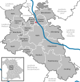