Category:St. Pierre (Mézières)
Jump to navigation
Jump to search
| Object location | | View all coordinates using: OpenStreetMap |
|---|
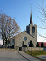
church building in Mézières in the canton of Fribourg, Switzerland  | |||||
| Upload media | |||||
| Instance of | |||||
|---|---|---|---|---|---|
| Part of | |||||
| Location |
| ||||
| Street address |
| ||||
| Heritage designation | |||||
 | |||||
Media in category "St. Pierre (Mézières)"
The following 5 files are in this category, out of 5 total.
-
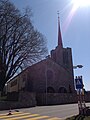 Kirche Mézières FR.jpg 1,936 × 2,592; 1.61 MB
-
 Meziereseglise.jpg 900 × 1,200; 1.19 MB
-
 Mézières (FR), église Saint-Pierre-aux-Liens, fonts baptismaux.jpg 2,272 × 1,704; 1.61 MB
-
 Mézières (FR), église Saint-Pierre-aux-Liens.jpg 2,272 × 1,704; 1.65 MB
-
 Saint-Pierre-au-Liens Mézières Oct 2010.jpg 3,168 × 4,752; 6.28 MB


,_%C3%A9glise_Saint-Pierre-aux-Liens,_fonts_baptismaux.jpg)
,_%C3%A9glise_Saint-Pierre-aux-Liens.jpg)