Category:United Kingdom photographs taken on 2009-03-21
Jump to navigation
Jump to search
Countries of Europe: Austria · Belarus · Belgium · Czech Republic · Denmark · Finland · France‡ · Germany · Hungary · Republic of Ireland · Italy · Latvia · Netherlands‡ · Norway · Poland · Portugal‡ · Russia‡ · Slovakia · Spain‡ · Sweden · Switzerland · Turkey‡ · Ukraine · United Kingdom
‡: partly located in Europe
‡: partly located in Europe
| ← | 21 March 2009 | → | ||
| ← | March 2009 | → | ||

United Kingdom photographs taken on 21 March 2009.
Image files should be categorized here automatically using {{taken on}} template. Direct categorisation is also possible, if automatic is impossible.
Subcategories
This category has the following 2 subcategories, out of 2 total.
Media in category "United Kingdom photographs taken on 2009-03-21"
The following 200 files are in this category, out of 1,852 total.
(previous page) (next page)-

-

-

-
 'The Bungalow' - geograph.org.uk - 1216286.jpg 640 × 476; 84 KB
-
 'The Burn' - geograph.org.uk - 1217072.jpg 640 × 439; 53 KB
-
 'The Pound' beside the A49 - geograph.org.uk - 1217818.jpg 600 × 450; 200 KB
-

-
-
 66414 Claycross Jct (3353560410).jpg 3,457 × 2,305; 2.33 MB
-

-
 A beech avenue at Town-o'-Rule - geograph.org.uk - 1216363.jpg 640 × 427; 120 KB
-
 A cattle grid at Womberton - geograph.org.uk - 1217719.jpg 600 × 450; 268 KB
-
 A clear footpath - geograph.org.uk - 1239692.jpg 640 × 480; 307 KB
-
 A Country Road - geograph.org.uk - 1220050.jpg 640 × 427; 121 KB
-
 A day on the beach - geograph.org.uk - 1213676.jpg 640 × 480; 60 KB
-
 A dismantled railway line near Saughtree - geograph.org.uk - 1213858.jpg 470 × 640; 134 KB
-
 A Duck on Crawley Village Pond - geograph.org.uk - 1216021.jpg 640 × 427; 53 KB
-
 A farm scene near Camps - geograph.org.uk - 1214161.jpg 640 × 480; 57 KB
-
 A laundry was here - geograph.org.uk - 1232185.jpg 640 × 426; 63 KB
-
 A line of dark trees - geograph.org.uk - 1237682.jpg 621 × 459; 143 KB
-

-
 A most substantial wall. - geograph.org.uk - 1223242.jpg 640 × 427; 83 KB
-
 A new workshop near Glass - geograph.org.uk - 1216314.jpg 640 × 433; 71 KB
-

-
 A rocky section on Glwndwr's Way - geograph.org.uk - 1214027.jpg 640 × 480; 93 KB
-
 A row of cottages in Airdrie - geograph.org.uk - 1214343.jpg 640 × 480; 65 KB
-
 A row of terraced housing, Bolton Rd - geograph.org.uk - 1217498.jpg 640 × 430; 61 KB
-
 A Saturday afternoon in mid-March - geograph.org.uk - 1213733.jpg 578 × 600; 57 KB
-
 A southbound train leaves Doniford - geograph.org.uk - 1216136.jpg 640 × 480; 62 KB
-
 A southerly view of Lochnabo - geograph.org.uk - 1213762.jpg 640 × 427; 142 KB
-
 A thousand years of history... - geograph.org.uk - 1221134.jpg 640 × 502; 196 KB
-
 A very muddy footpath - geograph.org.uk - 1238025.jpg 480 × 640; 288 KB
-

-
 A view to Mains of Rhynie - geograph.org.uk - 1217549.jpg 640 × 480; 74 KB
-
-
 A well walked path - geograph.org.uk - 1240844.jpg 631 × 465; 151 KB
-
 A willow crop at Town-o'-Rule - geograph.org.uk - 1216372.jpg 637 × 388; 141 KB
-
 A1 Newcastle Western Bypass - geograph.org.uk - 1213717.jpg 640 × 421; 69 KB
-

-
 A165 Roundabout - geograph.org.uk - 1213544.jpg 640 × 480; 42 KB
-
 A361 nearing Shipton Under Wychwood - geograph.org.uk - 1215963.jpg 640 × 427; 36 KB
-
 A40 west of Over - geograph.org.uk - 1221107.jpg 480 × 640; 54 KB
-
 A424 at Wyck Hill - geograph.org.uk - 1216146.jpg 640 × 427; 112 KB
-
 A882 at Roadside - geograph.org.uk - 1215788.jpg 640 × 425; 78 KB
-
 A882 entering Watten - geograph.org.uk - 1215586.jpg 640 × 442; 76 KB
-
 A882 near Thuster House - geograph.org.uk - 1216040.jpg 640 × 416; 59 KB
-
 A920 east from Springfield - geograph.org.uk - 1217302.jpg 640 × 480; 31 KB
-
 A920 over Market Hill - geograph.org.uk - 1217245.jpg 640 × 423; 43 KB
-
 A920 west from Oldmanse Farm - geograph.org.uk - 1216215.jpg 640 × 486; 54 KB
-
 Access road to the waterworks - geograph.org.uk - 1237867.jpg 624 × 456; 195 KB
-
 Access to 'Lettoch' - geograph.org.uk - 1217059.jpg 640 × 480; 73 KB
-
 Access to Annfield Mill - geograph.org.uk - 1217618.jpg 640 × 434; 99 KB
-
 Access to Bogforth - geograph.org.uk - 1216114.jpg 640 × 480; 94 KB
-
 Access to Burncroft - geograph.org.uk - 1217142.jpg 640 × 443; 73 KB
-
 Access to Cairnborrow Lodge - geograph.org.uk - 1216147.jpg 640 × 480; 105 KB
-
 Access to Culdrain House - geograph.org.uk - 1217334.jpg 640 × 480; 105 KB
-
 Access to Glass School - geograph.org.uk - 1216997.jpg 640 × 480; 133 KB
-
 Access to Muir Farm - geograph.org.uk - 1217657.jpg 640 × 480; 153 KB
-
 Access to Quarryhead farm - geograph.org.uk - 1217159.jpg 640 × 371; 65 KB
-
 Access to Wester Braetown - geograph.org.uk - 1217089.jpg 640 × 480; 40 KB
-
 Across the Tamar Valley - geograph.org.uk - 1218227.jpg 640 × 427; 119 KB
-
 Across the valley - geograph.org.uk - 1217834.jpg 600 × 450; 238 KB
-
 Adsett Court - geograph.org.uk - 1221480.jpg 506 × 640; 71 KB
-
 Affordable Housing Project - Fareham - geograph.org.uk - 1213670.jpg 640 × 480; 77 KB
-
 Afon Brân valley - geograph.org.uk - 1223662.jpg 640 × 426; 67 KB
-
 Afon Twyi and Dinas - geograph.org.uk - 1220374.jpg 640 × 426; 64 KB
-
 Afon Twyi Valley - geograph.org.uk - 1220380.jpg 640 × 426; 64 KB
-

-
 Afternoon sunshine in the woods - geograph.org.uk - 1240503.jpg 640 × 480; 297 KB
-
 Aircraft at Gloucestershire Airport - geograph.org.uk - 1221071.jpg 640 × 480; 61 KB
-
 Aire and Calder Navigation - Racca Green - geograph.org.uk - 1215354.jpg 640 × 430; 187 KB
-
 Airmyn A614 Roundabout - geograph.org.uk - 1214868.jpg 640 × 480; 66 KB
-
 Albion Court - geograph.org.uk - 1217462.jpg 640 × 430; 83 KB
-
 All boarded up - geograph.org.uk - 1235441.jpg 640 × 426; 52 KB
-
 Along the border - geograph.org.uk - 1219179.jpg 640 × 428; 51 KB
-
 An Sligearnach - geograph.org.uk - 1220147.jpg 640 × 411; 112 KB
-
 An unclear footpath - geograph.org.uk - 1238032.jpg 640 × 480; 283 KB
-
 Andover - A Homecoming. - geograph.org.uk - 1214276.jpg 640 × 429; 75 KB
-
 Anglers at Halton Quay - geograph.org.uk - 1220041.jpg 640 × 427; 79 KB
-
 Animal feeder - geograph.org.uk - 1240779.jpg 480 × 640; 284 KB
-
 Annagh River - geograph.org.uk - 1214129.jpg 640 × 480; 72 KB
-
 Annumhills Road - geograph.org.uk - 1214980.jpg 640 × 480; 53 KB
-

-
 Another pub closure - geograph.org.uk - 1230023.jpg 640 × 427; 75 KB
-
 Anthonys Travel coach (R40 ANT), 21 March 2009.jpg 1,600 × 1,200; 897 KB
-
 Approach to 'The Bungalow' - geograph.org.uk - 1216276.jpg 640 × 495; 105 KB
-
 Approach to 'The Burn' - geograph.org.uk - 1217126.jpg 640 × 464; 85 KB
-
 Approach to Dallochy - geograph.org.uk - 1216445.jpg 640 × 480; 125 KB
-
 Approach to Easter Boghead - geograph.org.uk - 1216168.jpg 640 × 555; 85 KB
-
-
 Approach to Highbush junction - geograph.org.uk - 1217150.jpg 640 × 480; 56 KB
-
 Approach to Oldmanse Farm - geograph.org.uk - 1216208.jpg 640 × 419; 72 KB
-
 Approach to Quarryhead - geograph.org.uk - 1217157.jpg 640 × 459; 57 KB
-
 Approach to Upper Mill - geograph.org.uk - 1217738.jpg 640 × 449; 67 KB
-
 Approaching 'The Smithy' - geograph.org.uk - 1217273.jpg 640 × 522; 78 KB
-
 Approaching Mill Farm - geograph.org.uk - 1213998.jpg 640 × 480; 123 KB
-
 Approaching Shipton-Under-Wychwood - geograph.org.uk - 1215978.jpg 640 × 427; 41 KB
-
 Arable, King's Hill Lane - geograph.org.uk - 1214411.jpg 640 × 392; 97 KB
-
 Ardyne Burn - geograph.org.uk - 1213994.jpg 640 × 480; 113 KB
-
 Arlingham from the air - geograph.org.uk - 1221437.jpg 480 × 640; 64 KB
-
 Asda Mount Pleasant, Hull - geograph.org.uk - 1215324.jpg 640 × 426; 217 KB
-
 Ash gill force and bridge - geograph.org.uk - 1392682.jpg 640 × 480; 103 KB
-
 Ashgill force - geograph.org.uk - 1392675.jpg 640 × 480; 118 KB
-
 Asloun junction - geograph.org.uk - 1217683.jpg 640 × 519; 76 KB
-
 At the feeding station - geograph.org.uk - 1216354.jpg 640 × 427; 141 KB
-
 Auchenblae Kirk - geograph.org.uk - 1219114.jpg 428 × 640; 64 KB
-
 Auchnafruin Cottage - geograph.org.uk - 1214044.jpg 640 × 480; 108 KB
-
 Aughton Plantation - geograph.org.uk - 1215009.jpg 640 × 480; 73 KB
-
 Auldyne farm - geograph.org.uk - 1217066.jpg 640 × 480; 41 KB
-
 Auldyne farm - geograph.org.uk - 1217068.jpg 640 × 480; 61 KB
-
 Austin Ten (3372884765).jpg 3,876 × 3,036; 8.29 MB
-
 B4577 going south west - geograph.org.uk - 1217773.jpg 600 × 450; 218 KB
-
 Back of the office - geograph.org.uk - 1232159.jpg 400 × 600; 49 KB
-
 Badger's Bank - geograph.org.uk - 1237617.jpg 640 × 480; 161 KB
-
 Badger's Bank - geograph.org.uk - 1237619.jpg 640 × 480; 205 KB
-
 Bagitall in Castle Street, Beaumaris - geograph.org.uk - 1218858.jpg 640 × 480; 117 KB
-
 Ballroom on top - geograph.org.uk - 1232200.jpg 640 × 426; 60 KB
-
 Barafundle Bay - geograph.org.uk - 1225161.jpg 640 × 479; 93 KB
-
 Barafundle Bay - geograph.org.uk - 1225171.jpg 640 × 479; 92 KB
-
 Baregains Lane, near Upper house - geograph.org.uk - 1217092.jpg 640 × 424; 74 KB
-
 Barge in the basin at Ardyne - geograph.org.uk - 1213986.jpg 640 × 480; 36 KB
-
 Barn at Bould - geograph.org.uk - 1216292.jpg 640 × 427; 100 KB
-
 Barn Conversion - geograph.org.uk - 1213555.jpg 640 × 480; 100 KB
-
 Barns and bales - geograph.org.uk - 1215596.jpg 640 × 425; 88 KB
-
 Barns with cattle - geograph.org.uk - 1216358.jpg 640 × 427; 100 KB
-
 Barrier bank near Misson - geograph.org.uk - 1214946.jpg 640 × 334; 62 KB
-
 Barrow Haven - geograph.org.uk - 1233855.jpg 640 × 480; 87 KB
-
 Barrow Haven - geograph.org.uk - 1233866.jpg 640 × 480; 68 KB
-
 Bartons Lane - geograph.org.uk - 1237697.jpg 624 × 465; 136 KB
-
 Basingstoke Canal, St John's - geograph.org.uk - 1213844.jpg 640 × 480; 116 KB
-
 Basingstoke Sewage Works - geograph.org.uk - 1237760.jpg 615 × 453; 124 KB
-
 Basingstoke Sewage Works - geograph.org.uk - 1237833.jpg 617 × 453; 101 KB
-
 Basingstoke Sewage Works - geograph.org.uk - 1237981.jpg 621 × 461; 117 KB
-
 Basingstoke Waterworks - geograph.org.uk - 1237968.jpg 620 × 462; 118 KB
-
 Bathan's Strand - geograph.org.uk - 1227667.jpg 640 × 480; 84 KB
-
 Beach below Knott - geograph.org.uk - 1214225.jpg 640 × 480; 202 KB
-
 Beach, Sandy Hirst - geograph.org.uk - 1227751.jpg 640 × 359; 95 KB
-
 Bealachandrain Farm - geograph.org.uk - 1214150.jpg 640 × 480; 90 KB
-
 Beaumaris bowling green - geograph.org.uk - 1218847.jpg 640 × 480; 181 KB
-
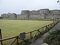 Beaumaris Castle and bowling green - geograph.org.uk - 1218849.jpg 640 × 480; 124 KB
-
 Beech trees at a field boundary - geograph.org.uk - 1216469.jpg 640 × 431; 132 KB
-

-
 Bell Street - geograph.org.uk - 1218292.jpg 640 × 480; 74 KB
-
 Bend in road and burn - geograph.org.uk - 1217047.jpg 640 × 493; 136 KB
-
 Bend in the road - geograph.org.uk - 1217078.jpg 640 × 538; 71 KB
-
 Bend on A97 - geograph.org.uk - 1217386.jpg 640 × 432; 54 KB
-
 Bennan Hill from Corse Craig - geograph.org.uk - 1218088.jpg 640 × 480; 74 KB
-
 Bessacarr shopping centre, Stoops Lane - geograph.org.uk - 1214899.jpg 640 × 480; 114 KB
-
 Bethesda Evangelical Church, Tenby Road - geograph.org.uk - 1233230.jpg 640 × 481; 152 KB
-
 Ceiling of Betws Penpont Church - geograph.org.uk - 1224824.jpg 426 × 640; 61 KB
-
 Tower of Betws Penpont Church - geograph.org.uk - 1224803.jpg 426 × 640; 63 KB
-
 Between the trees - geograph.org.uk - 1215665.jpg 640 × 480; 127 KB
-
 Betws Penpont Church - geograph.org.uk - 1223920.jpg 426 × 640; 61 KB
-
 Bilton-Lime Tree Avenue - geograph.org.uk - 1216350.jpg 640 × 480; 99 KB
-
 Bilton-Main Street - geograph.org.uk - 1216309.jpg 640 × 480; 80 KB
-
 Birch Cottage - geograph.org.uk - 1217563.jpg 640 × 497; 69 KB
-
 Birkby Fell - geograph.org.uk - 1215103.jpg 640 × 480; 73 KB
-
 Birmingham to Worcester Line - geograph.org.uk - 1213833.jpg 640 × 480; 226 KB
-
 Black mail^ - geograph.org.uk - 1214782.jpg 426 × 640; 82 KB
-
 Blackborough Road - geograph.org.uk - 1214999.jpg 640 × 426; 85 KB
-
 Blakenall Lane, Blakenall Heath - geograph.org.uk - 1213597.jpg 640 × 480; 92 KB
-
 Blakenall United Reformed Church - geograph.org.uk - 1213586.jpg 640 × 480; 72 KB
-
 Bloody Vale - geograph.org.uk - 1214054.jpg 481 × 640; 110 KB
-
 Bloody Vale - geograph.org.uk - 1215727.jpg 480 × 640; 79 KB
-
 Bloody Vale - geograph.org.uk - 1215737.jpg 481 × 640; 99 KB
-
 Bloody Vale looking East - geograph.org.uk - 1214059.jpg 640 × 456; 85 KB
-
 Blossom time in Sir Henry Parkes Road - geograph.org.uk - 1214294.jpg 640 × 470; 134 KB
-
 Blossom time, Memorial Park - geograph.org.uk - 1214431.jpg 640 × 480; 100 KB
-
 Blossom time, Memorial Park - geograph.org.uk - 1214461.jpg 640 × 480; 100 KB
-
 Blue plaque on Tenby House Hotel - geograph.org.uk - 1225017.jpg 640 × 480; 120 KB
-
 Boat Inn and Memorial Bridge - geograph.org.uk - 1215058.jpg 640 × 480; 102 KB
-
 Boats, Newcastle - geograph.org.uk - 1214364.jpg 640 × 355; 85 KB
-
 Bogforth steading - geograph.org.uk - 1216119.jpg 640 × 480; 103 KB
-
 Boggy track near Reroppie - geograph.org.uk - 1213446.jpg 640 × 427; 379 KB
-
 Bohetherick - geograph.org.uk - 1218252.jpg 640 × 427; 88 KB
-
 Bollards in the way - geograph.org.uk - 1230990.jpg 640 × 426; 38 KB
-
 Bolton Rd, Bury - geograph.org.uk - 1217455.jpg 640 × 430; 58 KB
-

-
 Bond's Corner - geograph.org.uk - 1213598.jpg 640 × 480; 68 KB
-
 Bond's Manor, Bond's Corner - geograph.org.uk - 1213643.jpg 640 × 480; 134 KB
-
 Bonfire by the mound - geograph.org.uk - 1237435.jpg 640 × 426; 88 KB
-
 Boot Street - geograph.org.uk - 1213684.jpg 640 × 480; 135 KB
-
 Booth Lane - geograph.org.uk - 1214886.jpg 640 × 480; 55 KB
-
 Booth Street, Blakenall - geograph.org.uk - 1213595.jpg 640 × 480; 68 KB
-
 Boughs of plum blossom - geograph.org.uk - 1214420.jpg 640 × 480; 300 KB
-
 Boundary fence on Cefn Waun-lwyd - geograph.org.uk - 1222980.jpg 640 × 426; 99 KB
-
 Boundary fence to former sewage works - geograph.org.uk - 1240821.jpg 621 × 462; 135 KB
-
 Bower Quarry - geograph.org.uk - 1215123.jpg 640 × 425; 83 KB
-
 Bowker Vale Metro link Station - geograph.org.uk - 1217242.jpg 640 × 430; 48 KB
-

-

-
 Bradley Manor 7802 Kidderminster (1).jpg 1,854 × 2,082; 2.36 MB
-
 Bradley Manor 7802 Kidderminster (2).jpg 4,752 × 3,168; 7.57 MB
-
 Bradley Manor 7802 Kidderminster (3).jpg 3,498 × 2,508; 5.97 MB
-
 Bradley Manor 7802 Kidderminster (5).jpg 2,105 × 1,117; 1.53 MB
-
 Bradley Manor 7802 Kidderminster.jpg 4,752 × 2,280; 6.43 MB
-
 St Peter's Chapel - geograph.org.uk - 1215289.jpg 640 × 345; 129 KB
-
 Brake Lane Railway Bridge - geograph.org.uk - 1213861.jpg 640 × 480; 303 KB
-
 Bridge - Racca Green - geograph.org.uk - 1215349.jpg 640 × 429; 186 KB
-
 Bridge by the bridge - geograph.org.uk - 1235648.jpg 640 × 426; 96 KB


_-_geograph.org.uk_-_1220866.jpg)


.jpg)


,_21_March_2009.jpg)


.jpg)


.jpg)
.jpg)
.jpg)
.jpg)


