File:'Matijevic Hill' Panorama for Rover's Ninth Anniversary.jpg

Original file (14,823 × 5,000 pixels, file size: 5.79 MB, MIME type: image/jpeg)
Captions
Captions
Summary[edit]
| Warning | The original file is very high-resolution. It might not load properly or could cause your browser to freeze when opened at full size. |
|---|
| Description |
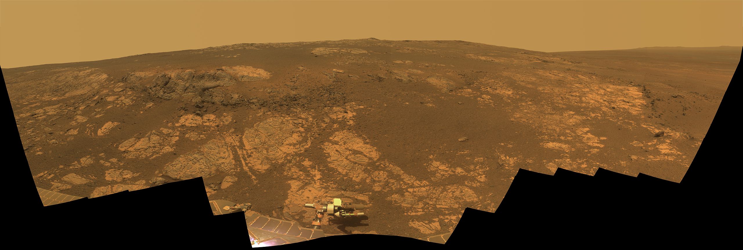
English: As NASA's Mars Exploration Rover Opportunity neared the ninth anniversary of its landing on Mars, the rover was working in the 'Matijevic Hill' area seen in this view from Opportunity's panoramic camera (Pancam). Opportunity landed Jan. 24, 2004, PST (Jan. 25 UTC). The landing site was about 12 miles (19 kilometers), straight-line distance, or about 22 miles (35.5 kilometers) driving-route distance, from this location on the western rim of Endeavour Crater.
Matijevic Hill is an area within the "Cape York" segment of Endeavour's rim where clay minerals have been detected from orbit. This view is centered northwestward, toward the crest of Cape York. It extends more than 210 degrees from left to right. The field of view encompasses most of the terrain traversed by Opportunity during a "walkabout" in October and November 2012 to scout which features to spend time examining more intensely. Two of the features investigated at Matijevic Hill are "Copper Cliff," the dark outcrop in the left center of the image, and "Whitewater Lake," the bright outcrop on the far right. Opportunity's Pancam took the component images for this mosaic during the period from the mission's 3,137th Martian day, or sol, (Nov. 19, 2012) through Sol 3150 (Dec. 3, 2012). The image combines exposures taken through Pancam filters centered on wavelengths of 753 nanometers (near-infrared), 535 nanometers (green) and 432 nanometers (violet). The view is presented in approximate true color. This "natural color" is the rover team's best estimate of what the scene would look like if humans were there and able to see it with their own eyes. |
| Date | between 19 November 2012 and 3 December 2012 |
| Source | http://www.nasa.gov/mission_pages/mer/multimedia/pia16703.html / http://photojournal.jpl.nasa.gov/catalog/PIA16703 |
| Author | NASA/JPL-Caltech/Cornell/Arizona State Univ. |
| Other versions |
|
This image or video was catalogued by Jet Propulsion Laboratory of the United States National Aeronautics and Space Administration (NASA) under Photo ID: PIA16703. This tag does not indicate the copyright status of the attached work. A normal copyright tag is still required. See Commons:Licensing. Other languages:
|
Licensing[edit]
| This file is in the public domain in the United States because it was solely created by NASA. NASA copyright policy states that "NASA material is not protected by copyright unless noted". (See Template:PD-USGov, NASA copyright policy page or JPL Image Use Policy.) | ||
 |
Warnings:
|
File history
Click on a date/time to view the file as it appeared at that time.
| Date/Time | Thumbnail | Dimensions | User | Comment | |
|---|---|---|---|---|---|
| current | 11:43, 22 February 2013 | 14,823 × 5,000 (5.79 MB) | Huntster (talk | contribs) | Full size image from original source. | |
| 18:22, 24 January 2013 | 7,500 × 2,530 (11.36 MB) | Stas1995 (talk | contribs) | User created page with UploadWizard |
You cannot overwrite this file.
File usage on Commons
The following 3 pages use this file:
.jpg)
.jpg)
File usage on other wikis
The following other wikis use this file:
- Usage on en.wikipedia.org
- Usage on ru.wikipedia.org
- Usage on ru.wikinews.org
- Usage on uk.wikipedia.org
- Usage on www.wikidata.org