File:(Plan of the town and harbour of St. Augustine. LOC 75693262.tif
Jump to navigation
Jump to search

Size of this JPG preview of this TIF file: 800 × 571 pixels. Other resolutions: 320 × 228 pixels | 640 × 456 pixels | 1,024 × 730 pixels | 1,280 × 913 pixels | 2,560 × 1,826 pixels | 3,061 × 2,183 pixels.
Original file (3,061 × 2,183 pixels, file size: 19.12 MB, MIME type: image/tiff)
Captions
Captions
Add a one-line explanation of what this file represents
Summary[edit]
| Description |
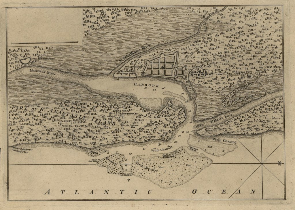
English: Scale ca. 1:47,000. Title from typed label mounted with map. Oriented with north to the right. Relief shown pictorially. Depth shown by soundings. Ascribed to William Roberts' An account of the first discovery and natural history of Florida, 1763 by typed label mounted with map. Differs from the map in Roberts' work and from the map in Thomas Jefferys' A description of the Spanish Islands ... 1762 in that it is wanting cartouche and title information, pagination in margin, and a statement in lower margin "T. Jefferys, sculp." LC Maps of North America, 1750-1789, 1637 Available also through the Library of Congress Web site as a raster image. Vault AACR2 |
||
| Title | [Plan of the town and harbour of St. Augustine. | ||
| Shelf ID | G3934.S2 1762 .J4 | ||
| Date | |||
| Source | https://www.loc.gov/item/75693262/ | ||
| Author | Jefferys, Thomas | ||
| Permission (Reusing this file) |
|
||
| Other versions |
|
||
| Location | United States · Florida · Saint Augustine | ||
| Part of | Military Battles And Campaigns · American Memory · Catalog · Geography And Map Division · American Revolution And Its Era: Maps And Charts Of North America And The West Indies, 1750-1789 | ||
| Subject | Florida · Early Works To 1800 · United States · Maps · Saint Augustine (Fla.) · Saint Augustine · Harbors |


Licensing[edit]
|
This is a faithful photographic reproduction of a two-dimensional, public domain work of art. The work of art itself is in the public domain for the following reason:
The official position taken by the Wikimedia Foundation is that "faithful reproductions of two-dimensional public domain works of art are public domain".
This photographic reproduction is therefore also considered to be in the public domain in the United States. In other jurisdictions, re-use of this content may be restricted; see Reuse of PD-Art photographs for details. | ||||
File history
Click on a date/time to view the file as it appeared at that time.
| Date/Time | Thumbnail | Dimensions | User | Comment | |
|---|---|---|---|---|---|
| current | 01:00, 12 June 2018 |  | 3,061 × 2,183 (19.12 MB) | Fæ (talk | contribs) | LOC Maps https://www.loc.gov/item/75693262/ #27448 |
You cannot overwrite this file.
File usage on Commons
The following page uses this file: