File:13TH ST. BETWEEN REESE AND SNOWDEN STS. SHOWING FIVE WOOD FRAME STRUCTURES WITH GABLED ROOFS - Silverton Historic District, Silverton, San Juan County, CO HABS COLO,56-SILTN,1-14.tif
Jump to navigation
Jump to search

Size of this JPG preview of this TIF file: 751 × 600 pixels. Other resolutions: 301 × 240 pixels | 601 × 480 pixels | 962 × 768 pixels | 1,280 × 1,022 pixels | 2,560 × 2,044 pixels | 5,000 × 3,993 pixels.
Original file (5,000 × 3,993 pixels, file size: 19.04 MB, MIME type: image/tiff)
Captions
Captions
Add a one-line explanation of what this file represents
Summary[edit]
| 13TH ST. BETWEEN REESE AND SNOWDEN STS. SHOWING FIVE WOOD FRAME STRUCTURES WITH GABLED ROOFS - Silverton Historic District, Silverton, San Juan County, CO | ||||
|---|---|---|---|---|
| Photographer |
Related names:
|
|||
| Title |
13TH ST. BETWEEN REESE AND SNOWDEN STS. SHOWING FIVE WOOD FRAME STRUCTURES WITH GABLED ROOFS - Silverton Historic District, Silverton, San Juan County, CO |
|||
| Depicted place | Colorado; San Juan County; Silverton | |||
| Date | Documentation compiled after 1933 | |||
| Dimensions | 4 x 5 in. | |||
| Current location |
Library of Congress Prints and Photographs Division Washington, D.C. 20540 USA http://hdl.loc.gov/loc.pnp/pp.print |
|||
| Accession number |
HABS COLO,56-SILTN,1-14 |
|||
| Credit line |
|
|||
| Notes |
|
|||
| References |
|
|||
| Source | https://www.loc.gov/pictures/item/co0020.photos.021892p | |||
| Permission (Reusing this file) |
|
|||

| Object location | | View this and other nearby images on: OpenStreetMap |
|---|
File history
Click on a date/time to view the file as it appeared at that time.
| Date/Time | Thumbnail | Dimensions | User | Comment | |
|---|---|---|---|---|---|
| current | 05:08, 8 July 2014 | 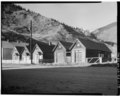 | 5,000 × 3,993 (19.04 MB) | Fæ (talk | contribs) | GWToolset: Creating mediafile for Fæ. HABS 05 July 2014 (501:600) |
You cannot overwrite this file.
File usage on Commons
The following page uses this file: