File:1946 numbering.jpg
Jump to navigation
Jump to search

Size of this preview: 603 × 600 pixels. Other resolutions: 241 × 240 pixels | 482 × 480 pixels | 772 × 768 pixels | 1,029 × 1,024 pixels | 1,749 × 1,740 pixels.
Original file (1,749 × 1,740 pixels, file size: 367 KB, MIME type: image/jpeg)
Captions
Captions
Add a one-line explanation of what this file represents
| Description |
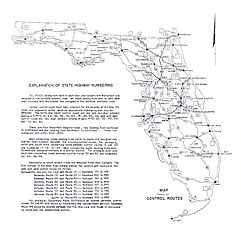
English: This is a map copyrighted by the State Road Department of Florida in 1946, showing the new numbering system. It comes from a larger map on Historical Maps of Florida at http://alabamamaps.ua.edu/historicalmaps/us_states/florida/index3.html. I searched Copyright renewal records at http://www.scils.rutgers.edu/~lesk/copyrenew.html and the SRD did not renew any copyrights. Therefore this map is now in the public domain.
Note: there is at least one typo; 20 between Gainesville and Ocala should read 25. |
|||
| Date | ||||
| Source | a larger map on Historical Maps of Florida at http://alabamamaps.ua.edu/historicalmaps/us_states/florida/index3.html | |||
| Author | State Road Department of Florida | |||
| Permission (Reusing this file) |
|
|||
| Other versions |
|


File history
Click on a date/time to view the file as it appeared at that time.
| Date/Time | Thumbnail | Dimensions | User | Comment | |
|---|---|---|---|---|---|
| current | 23:05, 26 August 2008 | | 1,749 × 1,740 (367 KB) | NE2 (talk | contribs) | There's no need for a full size version - when I try to load that one my browser stalls for a bit. |
| 11:24, 4 November 2007 |  | 3,498 × 3,479 (908 KB) | Jeff G. (talk | contribs) | Reverted to version as of 10:39, 12 October 2007 - no need for a half size version. | |
| 10:41, 12 October 2007 |  | 1,749 × 1,740 (367 KB) | NE2 (talk | contribs) | Cut to half the size; the full image is in the history if you need it. | |
| 10:39, 12 October 2007 |  | 3,498 × 3,479 (908 KB) | NE2 (talk | contribs) | This is a map copyrighted by the State Road Department of Florida in 1946, showing the new numbering system. It comes from a larger map on [http://alabamamaps.ua.edu/historicalmaps/us_states/florida/index3.html]. I searched [http://www.scils.rutgers.edu/~ |
You cannot overwrite this file.
File usage on Commons
There are no pages that use this file.
File usage on other wikis
The following other wikis use this file:
- Usage on es.wikipedia.org