File:273 WATER STREET IS FOUR-STORY BRICK HOUSE IN CENTER - South Street Seaport Museum, 273 Water Street, New York, New York County, NY HABS NY,31-NEYO,144-1.tif
Jump to navigation
Jump to search

Size of this JPG preview of this TIF file: 431 × 599 pixels. Other resolutions: 173 × 240 pixels | 345 × 480 pixels | 553 × 768 pixels | 737 × 1,024 pixels | 1,474 × 2,048 pixels | 3,599 × 5,000 pixels.
Original file (3,599 × 5,000 pixels, file size: 17.16 MB, MIME type: image/tiff)
Captions
Captions
Add a one-line explanation of what this file represents
Summary[edit]
| 273 WATER STREET IS FOUR-STORY BRICK HOUSE IN CENTER - South Street Seaport Museum, 273 Water Street, New York, New York County, NY | ||||
|---|---|---|---|---|
| Title |
273 WATER STREET IS FOUR-STORY BRICK HOUSE IN CENTER - South Street Seaport Museum, 273 Water Street, New York, New York County, NY |
|||
| Depicted place | New York; New York County; New York | |||
| Date | Documentation compiled after 1933 | |||
| Dimensions | 5 x 7 in. | |||
| Current location |
Library of Congress Prints and Photographs Division Washington, D.C. 20540 USA http://hdl.loc.gov/loc.pnp/pp.print |
|||
| Accession number |
HABS NY,31-NEYO,144-1 |
|||
| Credit line |
|
|||
| Notes |
|
|||
| Source | https://www.loc.gov/pictures/item/ny0909.photos.118846p | |||
| Permission (Reusing this file) |
|
|||

| Object location | | View this and other nearby images on: OpenStreetMap |
|---|
File history
Click on a date/time to view the file as it appeared at that time.
| Date/Time | Thumbnail | Dimensions | User | Comment | |
|---|---|---|---|---|---|
| current | 12:33, 29 July 2014 | 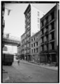 | 3,599 × 5,000 (17.16 MB) | Fæ (talk | contribs) | GWToolset: Creating mediafile for Fæ. HABS 24 July 2014 (2301:2600) |
You cannot overwrite this file.
File usage on Commons
The following page uses this file: