File:3-4 VIEW FROM WEST. - George Westinghouse Bridge, Spanning Turtle Creek at Lincoln Highway (U.S. Route 30), East Pittsburgh, Allegheny County, PA HAER PA,2-EAPIT,1-3.tif
Jump to navigation
Jump to search

Size of this JPG preview of this TIF file: 736 × 600 pixels. Other resolutions: 295 × 240 pixels | 589 × 480 pixels | 943 × 768 pixels | 1,257 × 1,024 pixels | 2,514 × 2,048 pixels | 5,000 × 4,073 pixels.
Original file (5,000 × 4,073 pixels, file size: 19.42 MB, MIME type: image/tiff)
Captions
Captions
Add a one-line explanation of what this file represents
Summary[edit]
| 3-4 VIEW FROM WEST. - George Westinghouse Bridge, Spanning Turtle Creek at Lincoln Highway (U.S. Route 30), East Pittsburgh, Allegheny County, PA | ||||
|---|---|---|---|---|
| Photographer |
Eliott, Joseph |
|||
| Title |
3-4 VIEW FROM WEST. - George Westinghouse Bridge, Spanning Turtle Creek at Lincoln Highway (U.S. Route 30), East Pittsburgh, Allegheny County, PA |
|||
| Description |
Booth and Flinn Company; Allegheny County Department of Public Works; Pennsylvania Department of Highways; Richardson, George S; Pribanic, Frank; Pribanic, Joe; Vittor, Frank; Armstrong, Joseph G; Babcock, E V; McGovern, Charles C; Barr, C M; Mansfield, W D; DeLony, Eric N, project manager; Pennsylvania Department of Transportation, sponsor; Pennsylvania Historical and Museum Commission, sponsor; Elliott, Joseph E, B, photographer; Rotenstein, David S, historian |
|||
| Depicted place | Pennsylvania; Allegheny County; East Pittsburgh | |||
| Date | 1997 | |||
| Dimensions | 4 x 5 in. | |||
| Current location |
Library of Congress Prints and Photographs Division Washington, D.C. 20540 USA http://hdl.loc.gov/loc.pnp/pp.print |
|||
| Accession number |
HAER PA,2-EAPIT,1-3 |
|||
| Credit line |
|
|||
| Notes |
|
|||
| References |
|
|||
| Source | https://www.loc.gov/pictures/item/pa3564.photos.361027p | |||
| Permission (Reusing this file) |
|
|||

| Object location | | View this and other nearby images on: OpenStreetMap |
|---|
File history
Click on a date/time to view the file as it appeared at that time.
| Date/Time | Thumbnail | Dimensions | User | Comment | |
|---|---|---|---|---|---|
| current | 03:45, 1 August 2014 | 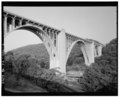 | 5,000 × 4,073 (19.42 MB) | Fæ (talk | contribs) | GWToolset: Creating mediafile for Fæ. HABS 31 July 2014 (3000:3200) |
You cannot overwrite this file.
File usage on Commons
The following page uses this file: