File:3-4 view, view to west. - Hungry Horse Village, Timber Sand Bunker, Approximately 1 mile south of Highway 2 East and 1-4 mile east of Colorado Boulevard, Hungry Horse, Flathead County, HABS MT-112-C-1.tif
Jump to navigation
Jump to search

Size of this JPG preview of this TIF file: 760 × 599 pixels. Other resolutions: 304 × 240 pixels | 609 × 480 pixels | 974 × 768 pixels | 1,280 × 1,010 pixels | 2,560 × 2,019 pixels | 5,594 × 4,412 pixels.
Original file (5,594 × 4,412 pixels, file size: 23.54 MB, MIME type: image/tiff)
Captions
Captions
Add a one-line explanation of what this file represents
Summary[edit]
| 3-4 view, view to west. - Hungry Horse Village, Timber Sand Bunker, Approximately 1 mile south of Highway 2 East and 1-4 mile east of Colorado Boulevard, Hungry Horse, Flathead County, MT | ||||
|---|---|---|---|---|
| Photographer |
Hager, Kristi Related names:
|
|||
| Title |
3-4 view, view to west. - Hungry Horse Village, Timber Sand Bunker, Approximately 1 mile south of Highway 2 East and 1-4 mile east of Colorado Boulevard, Hungry Horse, Flathead County, MT |
|||
| Depicted place | Montana; Flathead County; Hungry Horse | |||
| Date | 2005 | |||
| Dimensions | 4 x 5 in. | |||
| Current location |
Library of Congress Prints and Photographs Division Washington, D.C. 20540 USA http://hdl.loc.gov/loc.pnp/pp.print |
|||
| Accession number |
HABS MT-112-C-1 |
|||
| Credit line |
|
|||
| Notes |
|
|||
| Source | https://www.loc.gov/pictures/item/mt0466.photos.217586p | |||
| Permission (Reusing this file) |
|
|||

| Object location | | View this and other nearby images on: OpenStreetMap |
|---|
File history
Click on a date/time to view the file as it appeared at that time.
| Date/Time | Thumbnail | Dimensions | User | Comment | |
|---|---|---|---|---|---|
| current | 20:31, 28 July 2014 | 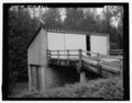 | 5,594 × 4,412 (23.54 MB) | Fæ (talk | contribs) | GWToolset: Creating mediafile for Fæ. HABS 24 July 2014 (2001:2300) |
You cannot overwrite this file.
File usage on Commons
The following page uses this file: