File:AERIAL VIEW OF BRIDGE FROM EAST - Baltimore and Ohio Railroad, Bollman Truss Bridge, Spanning Little Patuxent River, Savage, Howard County, MD HAER MD,14-SAV,1-1.tif
Jump to navigation
Jump to search

Size of this JPG preview of this TIF file: 742 × 599 pixels. Other resolutions: 297 × 240 pixels | 594 × 480 pixels | 951 × 768 pixels | 1,268 × 1,024 pixels | 2,536 × 2,048 pixels | 4,378 × 3,536 pixels.
Original file (4,378 × 3,536 pixels, file size: 14.77 MB, MIME type: image/tiff)
Captions
Captions
Add a one-line explanation of what this file represents
Summary[edit]
| AERIAL VIEW OF BRIDGE FROM EAST - Baltimore and Ohio Railroad, Bollman Truss Bridge, Spanning Little Patuxent River, Savage, Howard County, MD | ||||
|---|---|---|---|---|
| Photographer |
Barrett, William E. |
|||
| Title |
AERIAL VIEW OF BRIDGE FROM EAST - Baltimore and Ohio Railroad, Bollman Truss Bridge, Spanning Little Patuxent River, Savage, Howard County, MD |
|||
| Description |
Bollman, Wendel Alan, Designer; Christianson, Justine, transmitter |
|||
| Depicted place | Maryland; Howard County; Savage | |||
| Date | Documentation compiled after 1968; 1970 | |||
| Dimensions | 4 x 5 in. | |||
| Current location |
Library of Congress Prints and Photographs Division Washington, D.C. 20540 USA http://hdl.loc.gov/loc.pnp/pp.print |
|||
| Accession number |
HAER MD,14-SAV,1-1 |
|||
| Credit line |
|
|||
| Notes |
|
|||
| References |
|
|||
| Source | https://www.loc.gov/pictures/item/md0583.photos.082177p | |||
| Permission (Reusing this file) |
|
|||

| Object location | | View this and other nearby images on: OpenStreetMap |
|---|
File history
Click on a date/time to view the file as it appeared at that time.
| Date/Time | Thumbnail | Dimensions | User | Comment | |
|---|---|---|---|---|---|
| current | 02:08, 22 July 2014 | 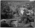 | 4,378 × 3,536 (14.77 MB) | Fæ (talk | contribs) | GWToolset: Creating mediafile for Fæ. HABS 21 July 2014 (1601:1800) |
You cannot overwrite this file.
File usage on Commons
The following page uses this file:
File usage on other wikis
The following other wikis use this file:
- Usage on en.wikipedia.org
- Usage on fr.wikipedia.org