File:ALEXANDER HAMILTON BRIDGE (FOREGROUND) AND WASHINGTON BRIDGE (BACKGROUND) SPANNING THE HARLEM RIVER - Alexander Hamilton Bridge, Spanning Harlem River between Bronx and Manhattan, HAER NY,3-BRONX,15-1.tif
Jump to navigation
Jump to search

Size of this JPG preview of this TIF file: 745 × 600 pixels. Other resolutions: 298 × 240 pixels | 596 × 480 pixels | 954 × 768 pixels | 1,272 × 1,024 pixels | 2,544 × 2,048 pixels | 5,000 × 4,026 pixels.
Original file (5,000 × 4,026 pixels, file size: 19.2 MB, MIME type: image/tiff)
Captions
Captions
Add a one-line explanation of what this file represents
Summary[edit]
| ALEXANDER HAMILTON BRIDGE (FOREGROUND) AND WASHINGTON BRIDGE (BACKGROUND) SPANNING THE HARLEM RIVER - Alexander Hamilton Bridge, Spanning Harlem River between Bronx and Manhattan, Bronx, Bronx County, NY | ||||
|---|---|---|---|---|
| Photographer |
Lowe, Jet |
|||
| Title |
ALEXANDER HAMILTON BRIDGE (FOREGROUND) AND WASHINGTON BRIDGE (BACKGROUND) SPANNING THE HARLEM RIVER - Alexander Hamilton Bridge, Spanning Harlem River between Bronx and Manhattan, Bronx, Bronx County, NY |
|||
| Depicted place | New York; Bronx County; Bronx | |||
| Date | 1991 | |||
| Dimensions | 4 x 5 in. | |||
| Current location |
Library of Congress Prints and Photographs Division Washington, D.C. 20540 USA http://hdl.loc.gov/loc.pnp/pp.print |
|||
| Accession number |
HAER NY,3-BRONX,15-1 |
|||
| Credit line |
|
|||
| Notes |
|
|||
| Source | https://www.loc.gov/pictures/item/ny1802.photos.351377p | |||
| Permission (Reusing this file) |
|
|||

| Camera location | | View this and other nearby images on: OpenStreetMap |
|---|
File history
Click on a date/time to view the file as it appeared at that time.
| Date/Time | Thumbnail | Dimensions | User | Comment | |
|---|---|---|---|---|---|
| current | 13:47, 28 February 2021 |  | 5,000 × 4,026 (19.2 MB) | Tm (talk | contribs) | Reverted to version as of 10:10, 1 August 2014 (UTC) |
| 06:17, 27 February 2021 |  | 4,690 × 3,690 (16.5 MB) | Featous (talk | contribs) | Cropped 6 % horizontally, 8 % vertically using CropTool with lossless mode. | |
| 10:10, 1 August 2014 | 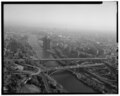 | 5,000 × 4,026 (19.2 MB) | Fæ (talk | contribs) | GWToolset: Creating mediafile for Fæ. HABS 31 July 2014 (2301:2600) |
You cannot overwrite this file.
File usage on Commons
The following page uses this file: