File:A chart of Delaware Bay and River - containing a full and exact description of the shores, creeks, harbours, soundings, shoals, sands, and bearings of the most considerable land marks, from the capes NYPL976368.tiff
Jump to navigation
Jump to search

Size of this JPG preview of this TIF file: 447 × 600 pixels. Other resolutions: 179 × 240 pixels | 358 × 480 pixels | 572 × 768 pixels | 763 × 1,024 pixels | 1,527 × 2,048 pixels | 4,344 × 5,827 pixels.
Original file (4,344 × 5,827 pixels, file size: 72.43 MB, MIME type: image/tiff)
Captions
Captions
Add a one-line explanation of what this file represents
Summary
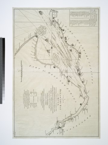
[edit]| Description | A chart of Delaware Bay and River : containing a full and exact description of the shores, creeks, harbours, soundings, shoals, sands, and bearings of the most considerable land marks, from the capes to Philadelphia / taken from the original chart published at Philadelphia by Joshua Fisher ; W. Haydon, sculpt.; Lawrence H. Slaughter Collection of English maps, charts, globes, books and atlases / Charts and maps | |||||||||||||||||||||||
| Notes | "According to Act of Parliament." ''Note 2.'') Depths shown by soundings. ''Note 3.'') Includes list of subscribers and "Tide table." ''Note 4.'') Lawrence H. Slaughter Collection ; 602. ''Note 5.'') National Endowment for the Humanities Grant for Access to Early Maps of the Middle Atlantic Seaboard. ''Note 6.'') Oriented with north to the right. ''Note 7.'') Shows ship channels. | |||||||||||||||||||||||
| Catalogue call number | Map Div. 97-6368 [LHS 602] | |||||||||||||||||||||||
| Standard reference | LC Maps of North America, 1750-1789, 1359 | |||||||||||||||||||||||
| Date | ||||||||||||||||||||||||
| Source |
http://digitalgallery.nypl.org/nypldigital/dgkeysearchdetail.cfm?imageID=976368
|
|||||||||||||||||||||||
| Author | Haydon, William -- Engraver ;Dury, Andrew -- Publisher; Fisher, Joshua, 1707-1783 -- Artist | |||||||||||||||||||||||
| Permission (Reusing this file) |
From The Lionel Pincus & Princess Firyal Map Division. http://maps.nypl.org
|
|||||||||||||||||||||||
| Location | Stephen A. Schwarzman Building / The Lionel Pincus and Princess Firyal Map Division | |||||||||||||||||||||||
| Digital item published | 5-24-2006; updated 3-25-2011 | |||||||||||||||||||||||
| Digital ID | 976368 | |||||||||||||||||||||||

The making of this file was supported by Wikimedia UK.
To see other files made with the support of Wikimedia UK, please see the category Supported by Wikimedia UK.
|
File history
Click on a date/time to view the file as it appeared at that time.
| Date/Time | Thumbnail | Dimensions | User | Comment | |
|---|---|---|---|---|---|
| current | 07:30, 20 April 2014 |  | 4,344 × 5,827 (72.43 MB) | Fæ (talk | contribs) | GWToolset:: Creating mediafile for Fæ. Tranche 2.229 |
You cannot overwrite this file.
File usage on Commons
There are no pages that use this file.