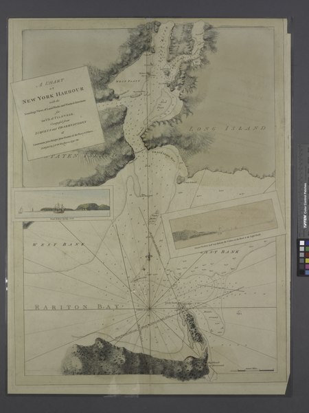
File:A chart of New York Harbour - with the soundings, views of land marks and nautical directions for the use of pilotage - composed from surveys and observations of lieutenants John Knight, John Hunter NYPL1692866.tiff
Jump to navigation
Jump to search
Size of this JPG preview of this TIF file: 450 × 599 pixels. Other resolutions: 180 × 240 pixels | 360 × 480 pixels | 576 × 768 pixels | 769 × 1,024 pixels | 1,537 × 2,048 pixels | 5,428 × 7,230 pixels.
Original file (5,428 × 7,230 pixels, file size: 112.28 MB, MIME type: image/tiff)
Captions
Captions
Add a one-line explanation of what this file represents
Summary[edit]
| Description | Maps of New York City and State / New York City / New York harbor; A chart of New York Harbour : with the soundings, views of land marks and nautical directions for the use of pilotage / composed from surveys and observations of lieutenants John Knight, John Hunter of the Navy and others. | |||||||||||||||||||||||
| Notes | Appears in Des Barres's Atlantic Neptune. ''Note 2.'') Inset views: Bond Hollow bearing s. b[y] e. -- Mount Pleasant half way between the cedars on the Hook and the light house. ''Note 3.'') NYPL copy appears to have been printed from a plate on which publication date has been mostly worn off. ''Note 4.'') Relief shown by hachures and shading, and depths shown by soundings. | |||||||||||||||||||||||
| Standard reference | LC Maps of North America, 1750-1789, 1232 | |||||||||||||||||||||||
| Date | May 1779? | |||||||||||||||||||||||
| Source |
http://digitalgallery.nypl.org/nypldigital/dgkeysearchdetail.cfm?imageID=1692866
|
|||||||||||||||||||||||
| Author | ||||||||||||||||||||||||
| Permission (Reusing this file) |
From The Lionel Pincus & Princess Firyal Map Division. http://maps.nypl.org
|
|||||||||||||||||||||||
| Location | Stephen A. Schwarzman Building / The Lionel Pincus and Princess Firyal Map Division | |||||||||||||||||||||||
| Digital item published | 2-20-2009; updated 5-16-2012 | |||||||||||||||||||||||
| Digital ID | 1692866 | |||||||||||||||||||||||

The making of this file was supported by Wikimedia UK.
To see other files made with the support of Wikimedia UK, please see the category Supported by Wikimedia UK.
|
File history
Click on a date/time to view the file as it appeared at that time.
| Date/Time | Thumbnail | Dimensions | User | Comment | |
|---|---|---|---|---|---|
| current | 07:30, 20 April 2014 |  | 5,428 × 7,230 (112.28 MB) | Fæ (talk | contribs) | GWToolset:: Creating mediafile for Fæ. Tranche 2.229 |
You cannot overwrite this file.
File usage on Commons
There are no pages that use this file.