File:A map of the British and French dominions in North America with the roads, distances, limits and extent of the settlements, humbly inscribed to the Right Honourable the Earl of Halifax and the other Right Honourable the RMG F0017.tiff
Jump to navigation
Jump to search

Size of this JPG preview of this TIF file: 486 × 599 pixels. Other resolutions: 194 × 240 pixels | 389 × 480 pixels | 623 × 768 pixels | 830 × 1,024 pixels | 1,660 × 2,048 pixels | 5,340 × 6,586 pixels.
Original file (5,340 × 6,586 pixels, file size: 100.62 MB, MIME type: image/tiff)
Captions
Captions
Add a one-line explanation of what this file represents
Summary[edit]
| Author |
John Mitchell; Kitchen, Thomas |
| Description |
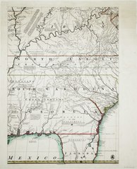
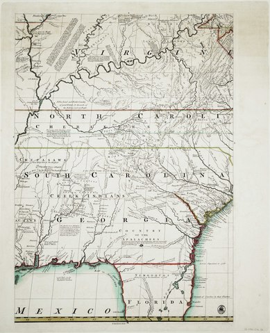
English: A map of the British and French dominions in North America with the roads, distances, limits and extent of the settlements, humbly inscribed to the Right Honourable the Earl of Halifax and the other Right Honourable the Lords Commissioners for Trade & Plantations, by ... Jno. Mitchell.Map on 8 sheets. Hand col. engr. Medium: On modern backing sheets. Physical description Note: Outline colour. Scale: [ca 1:2 000 000]. Cartographic Note: Graduated, London meridian. Contents Note: Numerous notes on Indian settlements, Inset (on sheet A): A new map of Huson's Bay and Labrador [ca. 1:10 000 000]. Map is 4 sheets wide and 2 sheets high. G292:5/2 G North America by Mitchell |
| Date | 1755 |
| Dimensions | Printed area of each sheet 69 x 49cm, on varying size sheets. |
| Notes | Title Note: This map was undertaken with the approbation and at the request of the Lords Commissioners for Trade and Plantations; and is chiefly composed from draughts, charts and actual surveys ... great part of which have been lately taken by their Lordships orders, and transmitted to this office by the Governors of the said colonies. John Pownall, Secretary, Plantation Office Feby. 13th 1755. |
| Source/Photographer | http://collections.rmg.co.uk/collections/objects/540688 |
| Permission (Reusing this file) |
The original artefact or artwork has been assessed as public domain by age, and faithful reproductions of the two dimensional work are also public domain. No permission is required for reuse for any purpose. The text of this image record has been derived from the Royal Museums Greenwich catalogue and image metadata. Individual data and facts such as date, author and title are not copyrightable, but reuse of longer descriptive text from the catalogue may not be considered fair use. Reuse of the text must be attributed to the "National Maritime Museum, Greenwich, London" and a Creative Commons CC-BY-NC-SA-3.0 license may apply if not rewritten. Refer to Royal Museums Greenwich copyright. |
| Identifier | id number: G292:5/2A previous number: G292:5/2A-H |
| Collection | Charts and maps |
Licensing[edit]
|
This is a faithful photographic reproduction of a two-dimensional, public domain work of art. The work of art itself is in the public domain for the following reason:
The official position taken by the Wikimedia Foundation is that "faithful reproductions of two-dimensional public domain works of art are public domain".
This photographic reproduction is therefore also considered to be in the public domain in the United States. In other jurisdictions, re-use of this content may be restricted; see Reuse of PD-Art photographs for details. | ||||
File history
Click on a date/time to view the file as it appeared at that time.
| Date/Time | Thumbnail | Dimensions | User | Comment | |
|---|---|---|---|---|---|
| current | 01:10, 29 August 2017 |  | 5,340 × 6,586 (100.62 MB) | Fæ (talk | contribs) | Royal Museums Greenwich Charts and maps, http://collections.rmg.co.uk/collections/objects/540688 |
You cannot overwrite this file.
File usage on Commons
The following page uses this file: