File:A new and exact map of the dominions of the King of Great Britain on ye continent of North America - containing Newfoundland, New Scotland, New England, New York, New Jersey, Pensilvania, Maryland, NYPL1693407.tiff
Jump to navigation
Jump to search

Size of this JPG preview of this TIF file: 410 × 599 pixels. Other resolutions: 164 × 240 pixels | 329 × 480 pixels | 526 × 768 pixels | 701 × 1,024 pixels | 1,403 × 2,048 pixels | 4,644 × 6,780 pixels.
Original file (4,644 × 6,780 pixels, file size: 90.09 MB, MIME type: image/tiff)
Captions
Captions
Add a one-line explanation of what this file represents
Summary[edit]
| Description | A new and exact map of the dominions of the King of Great Britain on ye continent of North America : containing Newfoundland, New Scotland, New England, New York, New Jersey, Pensilvania, Maryland, Virginia and Carolina / according to the newest and most exact observations by Herman Moll, geographer. | |||||||||||||||||||||||
| Notes | Imprint on map: Printed and sold by Tho. Bowles next ye Chapter House in St Pauls Church-yard, John Bowles at the Black Horse in Cornhill, and by I. King at ye Globe in ye Poultrey near Stocks Market. Note 2.) Includes descriptive text, coat of arms with dedication dated 1715, and note in inset about an event of 1730. Note 3.) NYPL copy has handwritten in ink on verso, in two places in upper right near fold: No. 8. Note 4.) Prime meridian: London. Note 5.) Relief shown pictorially. | |||||||||||||||||||||||
| Standard reference | Stevens & Tree. Comparative cartography, 55c | |||||||||||||||||||||||
| Physical description | 1 map : hand col. ; 100 x 60 cm., folded to 64 x 28 cm. | |||||||||||||||||||||||
| Date | i.e. 1731? | |||||||||||||||||||||||
| Source |
http://digitalgallery.nypl.org/nypldigital/dgkeysearchdetail.cfm?imageID=1693407
|
|||||||||||||||||||||||
| Author | Moll, Herman, d. 1732 -- Geographer (not in Relator list) | |||||||||||||||||||||||
| Permission (Reusing this file) |
From The Lionel Pincus & Princess Firyal Map Division. Released on a CC0 license.[1] | |||||||||||||||||||||||
| Digital ID | 1693407 | |||||||||||||||||||||||
| Location | Stephen A. Schwarzman Building / The Lionel Pincus and Princess Firyal Map Division | |||||||||||||||||||||||
| NYPL digital item published | 2-24-2009; updated 3-25-2011 | |||||||||||||||||||||||

Licensing[edit]
| This file is made available under the Creative Commons CC0 1.0 Universal Public Domain Dedication. | |
| The person who associated a work with this deed has dedicated the work to the public domain by waiving all of their rights to the work worldwide under copyright law, including all related and neighboring rights, to the extent allowed by law. You can copy, modify, distribute and perform the work, even for commercial purposes, all without asking permission.
|
The making of this file was supported by Wikimedia UK.
To see other files made with the support of Wikimedia UK, please see the category Supported by Wikimedia UK.
|
File history
Click on a date/time to view the file as it appeared at that time.
| Date/Time | Thumbnail | Dimensions | User | Comment | |
|---|---|---|---|---|---|
| current | 14:15, 6 April 2014 | 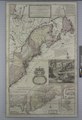 | 4,644 × 6,780 (90.09 MB) | Fæ (talk | contribs) | =={{int:filedesc}}== {{NYPL_map |digital_id = 1693407 |standard_reference = Stevens & Tree. Comparative cartography, 55c |record_id = 1862507 |creator = Moll, Herman, d. 1732 -- Geographer (not in Relator list) |link_catalog = http://digitalgallery.ny... |
You cannot overwrite this file.
File usage on Commons
There are no pages that use this file.