File:A new map of Virginia - from the best authorities - by T. Kitchen, geogr. NYPL433988.tiff
Jump to navigation
Jump to search

Size of this JPG preview of this TIF file: 534 × 600 pixels. Other resolutions: 214 × 240 pixels | 427 × 480 pixels | 684 × 768 pixels | 911 × 1,024 pixels | 1,823 × 2,048 pixels | 4,368 × 4,907 pixels.
Original file (4,368 × 4,907 pixels, file size: 61.33 MB, MIME type: image/tiff)
Captions
Captions
Add a one-line explanation of what this file represents
Summary[edit]
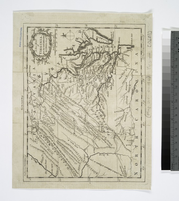
| Description | A new map of Virginia : from the best authorities / by T. Kitchen, geogr. | |||||||||||||||||||||||
| Notes | Ford Collection. Note 2.) From London magazine, v. 30, November 1761. Note 3.) In upper margin: For the Lond: mag. Note 4.) National Endowment for the Humanities Grant for Access to Early Maps of the Middle Atlantic Seaboard. Note 5.) Prime meridians: London and Philadelphia. Note 6.) Relief shown pictorially. | |||||||||||||||||||||||
| Standard reference | Jolly, D.C. Maps of America in periodicals before 1800, 181; LC Maps of North America, 1750-1789, 1436 | |||||||||||||||||||||||
| Physical description | 1 map ; 17 x 22 cm. | |||||||||||||||||||||||
| Catalog Call Number | Map Div. 01-1960 [Filed with Virginia, 1760?, as originally cataloged in NYPL Dictionary Catalog of the Map Division] | |||||||||||||||||||||||
| Date | ||||||||||||||||||||||||
| Source |
http://digitalgallery.nypl.org/nypldigital/dgkeysearchdetail.cfm?imageID=433988
|
|||||||||||||||||||||||
| Author | Kitchin, Thomas, d. 1784 -- Geographer (not in Relator list) | |||||||||||||||||||||||
| Permission (Reusing this file) |
From The Lionel Pincus & Princess Firyal Map Division. Released on a CC0 license.[1] | |||||||||||||||||||||||
| Digital ID | 433988 | |||||||||||||||||||||||
| Location | Stephen A. Schwarzman Building / The Lionel Pincus and Princess Firyal Map Division | |||||||||||||||||||||||
| NYPL digital item published | 2-3-2004; updated 3-25-2011 | |||||||||||||||||||||||

Licensing[edit]
| This file is made available under the Creative Commons CC0 1.0 Universal Public Domain Dedication. | |
| The person who associated a work with this deed has dedicated the work to the public domain by waiving all of their rights to the work worldwide under copyright law, including all related and neighboring rights, to the extent allowed by law. You can copy, modify, distribute and perform the work, even for commercial purposes, all without asking permission.
|
The making of this file was supported by Wikimedia UK.
To see other files made with the support of Wikimedia UK, please see the category Supported by Wikimedia UK.
|
File history
Click on a date/time to view the file as it appeared at that time.
| Date/Time | Thumbnail | Dimensions | User | Comment | |
|---|---|---|---|---|---|
| current | 02:17, 9 April 2014 |  | 4,368 × 4,907 (61.33 MB) | Fæ (talk | contribs) | =={{int:filedesc}}== {{NYPL_map |digital_id = 433988 |standard_reference = Jolly, D.C. Maps of America in periodicals before 1800, 181; LC Maps of North America, 1750-1789, 1436 |record_id = 252841 |catalog_call_number = Map Div. 01-1960 [Filed with Vi... |
You cannot overwrite this file.
File usage on Commons
There are no pages that use this file.