File:Abridged Copy of the Geographical Map in the Inner Court of the Qing Dynasty WDL11426.pdf
Jump to navigation
Jump to search

Size of this JPG preview of this PDF file: 342 × 598 pixels. Other resolutions: 137 × 240 pixels | 274 × 480 pixels | 439 × 768 pixels | 585 × 1,024 pixels | 1,429 × 2,500 pixels.

Original file (1,429 × 2,500 pixels, file size: 25.65 MB, MIME type: application/pdf, 115 pages)
Captions
Captions
Add a one-line explanation of what this file represents
Summary[edit]
| Author |
Русский: Лю Янь, работал в XIX веке
Français : Liu, Yan, actif au XIXe siècle
English: Liu, Yan, active 19th century
中文:六严,活跃于十九世纪
Português: Liu, Yan, ativo no século XIX
العربية: ليو، يان، نَشِط في القرن التاسع عشر
Español: Liu, Yan, en actividad en el siglo XIX |
| Title |
Русский: Сокращенное издание географической карты из внутреннего двора династии Цин
Français : Copie abrégée de la carte géographique de la cour intérieure de la dynastie Qing
English: Abridged Copy of the Geographical Map in the Inner Court of the Qing Dynasty
中文:清内府舆地图缩摹本
Português: Cópia resumida do mapa geográfico da corte interna da dinastia Qing
العربية: نسخة مختصرة للخريطة الجغرافية في البلاط الداخلي لأسرة تشينغ
Español: Copia abreviada del mapa geográfico en la corte interna de la dinastía Qing |
| Description |
Русский: Данная работа написана Лю Янем, также известным как Дэчжи, ученым-историком, географом и астрономом среднего и позднего периода правления династии Цин. Лю Янь является автором и соавтором ряда работ в области географии, включая "Цзи юань бянь" ("Словарь названий периодов правления"), "Ли дай ди ли янь гэ ту" ("Историко-географический атлас династий") и "Ли дай ди ли чжи юнь бянь цзинь ши" ("Словарь географических названий с новыми пояснениями"). Несмотря на то что большинство его работ вышло под именем его учителя, известного географа Ли Чжаоло (1769–1841 гг.), вклад Лю Яня в науку неоспорим. Лю Янь использовал работу своего дяди, Лю Чэнжу, также бывшего учеником Ли Чжаоло, на основе которой создал эту сокращенную версию карты, опубликованную в 14-й год правления (1834 г.) императора Даогуана (годы правления 1821–1850) под заглавием "Хуан чао нэй фу юй ди ту со мо бэнь" ("Сокращенное издание географической карты из внутреннего двора династии Цин"). Эта работа разделена на три части. Первая часть состоит из собрания исторических рассказов о династии Цин, вторая часть посвящена пахотным землям, налоговому регулированию и обычаям, а третья часть содержит карты судоходных путей. Перед титульным листом и после него приведена упрощенная карта мира. В начале рукописи находится надпись, сделанная Вэном Тунхэ (1830–1904 гг.), конфуцианским ученым и членом Академии Ханьлинь, который позже был назначен министром доходов, общественных работ и военных дел. Вэн Тунхэ сделал копию этой рукописи с комментариями, работая составителем в Академии Ханьлинь. Это произошло вскоре после англо-французского вторжения в Китай 1858–1860 годов — события, которое привлекло внимание к географии Синьцзяна и дипломатической работе, касающейся границ с четырьмя основными внешними державами (Великобританией, Францией, Соединенными Штатами и Россией). В работе приводятся сведения о координатах гор, рек и казарм, расположенных в стратегически важных точках. Также представляют интерес рассуждения о торговле и различных переговорах между Китаем и правительствами других государств. Среди примечаний, выполненных красными, черными, желтыми и зелеными чернилами, есть, например, надпись "Торговля с Тайванем", расположенная рядом с надписью "Луэрмынь" — названием морского порта в Тайнане, Тайвань. Став учителем императора Гуансюя, Вэн Тунхэ с помощью этой рукописи учил его ведению переговоров относительно защиты границ.
Торговля; Географические справочники; Историческая география; Нравы и обычаи; Налогообложение Français : Cet ouvrage fut réalisé par Liu Yan, également appelé Dezhi, érudit d'histoire, de géographie et d'astronomie du milieu et de la fin de la dynastie Qing. Liu Yan produisit et contribua à plusieurs ouvrages de géographie, dont Ji yuan bian (Dictionnaire des noms de règne), Li dai di li yan ge tu (Un atlas historique et géographique des dynasties) et Li dai di li zhi yun bian jin shi (Dictionnaire des noms géographiques avec de nouvelles explications). Bien que la plupart de ses œuvres aient été publiées sous le nom de son professeur, le célèbre géographe Li Zhaoluo (1769–1841), la contribution de Liu Yan à l'avancement des connaissances est incontestable. Il s'inspira d'un ouvrage de son oncle Liu Chengru, également élève de Li Zhaoluo, pour réaliser cette copie dans un format plus petit, qui parut la 14e année (1834) de l'empereur Daoguang (règne : 1821–1850) avec l'inscription : Huang chao nei fu yu di tu suo mo ben (Copie abrégée de la carte géographique de la cour intérieure de la dynastie Qing). L'ouvrage est composé de trois parties. La première raconte des anecdotes historiques sur la dynastie, la seconde aborde les terres arables, la réglementation fiscale et les coutumes, et la troisième contient des cartes des voies navigables. Des cartes du monde simplifiées précèdent et suivent la page de titre. La couverture comporte une inscription de Weng Tonghe (1830–1904), érudit confucéen et membre de l'Académie Hanlin, qui devint plus tard ministre du revenu, des travaux publics et de la guerre. Weng Tonghe copia l'ouvrage, en ajoutant des commentaires, lorsqu'il travaillait comme compilateur de Hanlin, juste après l'invasion anglo-française de la Chine de 1858 à 1860, événement qui attira l'attention sur la géographie du Xinjiang et les activités diplomatiques concernant les frontières avec les quatre principales puissances extérieures (la Grande-Bretagne, la France, les États-Unis et la Russie). L'ouvrage fournit des informations sur les emplacements des montagnes, des fleuves et des casernes aux points stratégiques. Les discussions sur le commerce et les diverses négociations entre la Chine et les gouvernements étrangers présentent également un intérêt particulier. Les annotations sont écrites en rouge, en noir, en jaune et en vert, avec notamment une note indiquant « Commerce avec Taiwan » près du nom de lieu Lu'ermen, port de Tainan, à Taiwan. Lorsque Weng Tonghe devint tuteur de l'empereur Guangxu, il utilisa ce manuscrit pour l'instruire sur les négociations concernant la protection des frontières.
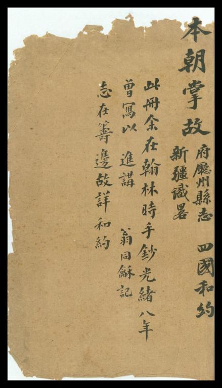
Commerce; Gazetiers; Géographie historique; Mœurs et coutumes; Imposition English: This work is by Liu Yan, also called Dezhi, a middle- and late-Qing dynasty scholar in history, geography, and astronomy. Liu Yan produced and contributed to a number of works in the field of geography, including Ji yuan bian (Dictionary of reign names), Li dai di li yan ge tu (A historical geographical atlas of dynasties), and Li dai di li zhi yun bian jin shi (Dictionary of geographical names with new explanations). Although most of his works appeared under the name of his teacher, the renowned geographer Li Zhaoluo (1769–1841), Liu Yan’s contribution to scholarship is indisputable. He used a work written by his uncle Liu Chengru, also a student of Li Zhaoluo, to produce this copy in reduced size, which was published in the 14th year (1834) of Emperor Daoguang (reigned 1821–50) with the inscription: Huang chao nei fu yu di tu suo mo ben (Abridged copy of the geographical map in the inner court of the Qing dynasty). The work is in three parts. Part one consists of historical anecdotes about the dynasty; part two deals with arable land, tax regulations, and customs; part three features charts of waterways. Simplified world maps appear before and after the title page. At the front is an inscription by Weng Tonghe (1830–1904), a Confucian scholar and a member of the Hanlin Academy, who later became minister of the Ministry of Revenue, Public Works, and War. Weng Tonghe copied the work, with commentaries, when he was working as a Hanlin compiler. This was shortly after the Anglo-French invasion of China of 1858–60, an event that focused attention on the geography of Xinjiang and the diplomatic activities concerning borders with the four main external powers (Great Britain, France, the United States, and Russia). The work provides information about the locations of mountains, rivers, and barracks at strategic points. Also interesting are the discussions of commerce and of various negotiations between China and foreign governments. Annotations are written in red, black, yellow, and green colors with, for example, a note that reads “Commerce with Taiwan” next to the place-name of Lu’ermen, a seaport in Tainan, Taiwan. When Weng Tonghe became the tutor of Emperor Guangxu, he used this manuscript to instruct the emperor about negotiations concerning border protection.
Commerce; Gazetteers; Historical geography; Manners and customs; Taxation 中文:本图为清代江阴文人六严所作。六严,字德只,是一位清代中晚期重要的历史、地理、天文学者,著书众多。除《清内府舆地图缩摹本》以外,另著有《纪元编》、《历代地理沿革图》、《历代地理志韻编今释》等书。虽然此作者大部分著作以其师著名地理学家李兆洛(1769-1841年)为名,六严的学术贡献是不可争辩的。此馆藏本创作年代约道光十四年(1834年)。六严参考了其伯父六承如 (也为李兆洛门生)所著作《皇朝内府舆地图缩摹本》而成。内容分三部分:一为本朝掌故;一为田数、赋则、关税;一为水道表。书名页前后两面各有世界地图略图一幅。卷首有清人翁同龢(1830-1904年)题记。翁氏为一位儒学家及翰林院学士,先后充任戶部、工部及兵部尚书。翁同龢在咸丰六年(1856年)翰林院担任编修时曾抄录此书。当时正徝英法联军之役(1858-60年)未久,故他尤其注重有关新疆地理以及中国与英、法、美、俄四国之间牵涉到边疆地理的外交活动。从国家图书馆所藏此书中可见,他依据道光后疆域情势,补充了原书未载的山川位置、营垒要冲等。值得注意的为中国和外国政府多次交涉与通商之情。此书以红、黑、黄、绿色标志批注,如在台湾台南海港鹿耳门地名旁边加注「台湾通商」等字。翁同龢曾任军机大臣,并历加太子太保,曾为皇帝讲学,以此书讲述筹备边防交涉过程。
商业; 地方史; 历史地理学; 风俗礼仪; 税制 Português: Esta obra é de Liu Yan, também chamado de Dezhi, um estudioso de história, geografia e astronomia de meados e do fim da dinastia Qing. Liu Yan produziu e contribuiu com várias obras no campo da geografia, incluindo Ji yuan bian (Dicionário de nomes de reinados), Li dai di li yan ge tu (Um atlas histórico e geográfico das dinastias) e Li dai di li zhi yun bian jin shi (Dicionário de nomes geográficos com novas explicações). Embora a maioria de suas obras tenha aparecido sob o nome de seu professor, o renomado geógrafo Li Zhaoluo (1769 a 1841), a contribuição de Liu Yan à academia é irrefutável. Ele usou uma obra escrita por seu tio Liu Chengru, também aluno de Li Zhaoluo, para produzir esta cópia em tamanho reduzido, que foi publicada no décimo quarto ano (1834) do Imperador Daoguang (que reinou entre 1821 e 1850) com o nome: Huang chao nei fu yu di tu suo mo ben (Cópia resumida do mapa geográfico da corte interna da dinastia Qing). A obra é dividida em três partes. A primeira parte é composta por anedotas históricas sobre a dinastia; a segunda parte lida com a terra arável, a regulamentação tributária e os costumes; a terceira parte apresenta tabelas de vias marítimas. Mapas-múndi simplificados aparecem antes e depois da página de rosto. Na frente, há uma dedicatória escrita por Weng Tonghe (1830 a 1904), estudioso de Confúcio e integrante da Academia de Hanlin, que depois virou ministro do Ministério do Fisco, das Obras Públicas e da Guerra. Weng Tonghe copiou a obra, com comentários, enquanto trabalhava como compilador em Hanlin. Isso aconteceu pouco depois da invasão anglo-francesa da China entre 1858 e 1860, um evento que chamou atenção para a geografia de Xinjiang e para as atividades diplomáticas das fronteiras com as quatro principais potências estrangeiras (Grã-Bretanha, França, Estados Unidos e Rússia). A obra fornece informações sobre as localizações de montanhas, rios e quartéis em pontos estratégicos. Também é interessante ver as discussões sobre o comércio e os vários negócios feitos entre a China e governos estrangeiros. Há anotações escritas em vermelho, preto, amarelo e verde, como, por exemplo, uma nota que diz “Comércio com Taiwan” próxima do topônimo Lu'ermen, que é um porto de Tainan, em Taiwan. Quando Weng Tonghe virou o tutor do Imperador Guangxu, ele usou este manuscrito para orientar o imperador sobre negociações a respeito da proteção de fronteiras.
Comércio; Dicionários geográficos; Geografia histórica; Usos e costumes; Impostos العربية: يعود هذا العمل لليو يان، يُسمى أيضاً دَهتشى، وهو باحث في التاريخ والجغرافيا وعلم الفلك عاصر منتصف وأواخر عهد أسرة تشينغ. أنتج ليو يان وساهم في عدد من الأعمال في مجال الجغرافيا، بما في ذلك جي يوان بيان (قاموس أسماء الملوك) ولي داي دي لي يان غي تو (الأطلس الجغرافي التاريخي للأُسَر)، ولي داي دي لي جي يوَّنْ بيان جين شي (معجم الأسماء الجغرافية المزود بتوضيحات جديدة). على الرغم من ظهور معظم أعمال ليو يان تحت اسم معلمه، الجغرافي الشهير لي تشولو (1769–1841)، تعد مساهمة ليو يان في العلم غير قابلة للمناقشة. استخدم ليو يان عملاً كتبه عمه ليو تشونغ رو، الذي كان طالباً أيضاً عند لي تشولو، لينتج هذه النسخة بحجم أصغر، حيث نُشِرت في العام الرابع عشر (1834) من حُكْم الامبراطور دوغوانغ (حَكَم من 1821–1850) وكُتِب عليها هوانغ تشاو ناي فو يو دي تو سو مو بن (نسخة مختصرة للخريطة الجغرافية في البلاط الداخلي لأسرة تشينغ). يتكون العمل من ثلاثة أجزاء. يتكون الجزء الأول من نوادر تاريخية حول الأسرة ويتناول الجزء الثاني الأرض الصاحلة للزراعة ولوائح الضرائب والعادات ويُبرز الجزء الثالث خرائط للممرات المائية. تظهر خرائط مبسطة للعالم قبل صفحة العنوان وبعدها. يوجد نقش في البداية كتبه وونغ تونغ (1830–1904)، عالم كونفوشيوسي وعضو في أكاديمية هانلين، أصبح فيما بعد وزيراً في وزارة المالية والأشغال العامة والحربية. نَسَخ وونغ تونغ العمل، مع الشروح، عندما كان يعمل مؤلفاً في هانلين. كان هذا بعد وقت قصير من الغزو الأنغلو فرنسي للصين في 1858–1860، وهو الحدث الذي ركَّز الاهتمام على جغرافيا شينجيانغ والأنشطة الدبلوماسية المتعلقة بالحدود مع القوى الخارجية الأربعة الرئيسية (بريطانيا العظمى وفرنسا والولايات المتحدة وروسيا). يقدم العمل معلومات حول مواقع الجبال والأنهار والثكنات في نقاط استراتيجية. من المثير للاهتمام أيضاً مناقشات التجارة والمفاوضات المتعددة بين الصين والحكومات الأجنبية. كُتبت التوضيحات بالألوان الأحمر والأسود والأصفر والأخضر، مع ملاحظة مكتوب فيها "التجارة مع تايوان" بجانب لويرمن، ميناء بحري في تاينان، تايوان، على سبيل المثال. عندما أصبح وونغ تونغ معلم الإمبراطور غوانغشو، استخدم هذه المخطوطة لإرشاد الإمبراطور حول المفاوضات المتعلقة بحماية الحدود.
التجارة; المعاجم الجغرافية; الجغرافيا التاريخية; السلوكيات والعادات; الضرائب Español: Esta obra es de Liu Yan, también llamado Dezhi, un erudito en historia, geografía y astronomía de mediados y finales de la dinastía Qing. Liu Yan produjo varias obras y colaboró en otras en el campo de la geografía, entre las que están Ji yuan bian (Diccionario de nombres del reinado), Li dai di li yan ge tu (Un atlas histórico y geográfico de las dinastías) y Li dai di li zhi yun bian jin shi (Diccionario de nombres geográficos con nuevas explicaciones). Aunque la mayor parte de sus obras aparecieron bajo el nombre de su maestro, el famoso geógrafo Li Zhaoluo (1769-1841), la contribución de Liu Yan a la erudición es indiscutible. Utilizó una obra escrita por su tío, Liu Chengru, también estudiante de Li Zhaoluo, para producir esta copia en tamaño reducido, que se publicó en el año 14 (1834) del reinado del emperador Daoguang (entre 1821 y 1850) con la inscripción: Huang chao nei fu yu di tu suo mo ben (Copia abreviada del mapa geográfico en la corte interna de la dinastía Qing). La obra se divide en tres partes. La primera consiste en anécdotas históricas sobre la dinastía; la segunda trata de las tierras de cultivo, la normativa fiscal y la aduana; y la tercera presenta cartas de las vías fluviales. Antes y después de la portada aparecen mapas del mundo simplificados. En el frente hay una inscripción de Weng Tonghe (1830-1904), un erudito confuciano y miembro de la academia Hanlin, que más tarde se convirtió en ministro de Hacienda, Obras Públicas y Guerra. Weng Tonghe copió la obra, con sus comentarios, cuando trabajaba como compilador de Hanlin. Esto fue poco después de la invasión anglo-francesa a China, de 1858 a 1860, un evento que centró la atención en la geografía de Xinjiang y en las actividades diplomáticas en materia de fronteras con las cuatro principales potencias externas (Gran Bretaña, Francia, Estados Unidos y Rusia). La obra proporciona información sobre la ubicación de las montañas, los ríos y los cuarteles en puntos estratégicos. También resultan interesantes los debates sobre el comercio y sobre diversas negociaciones entre China y los gobiernos extranjeros. Hay anotaciones escritas en colores rojo, negro, amarillo y verde: por ejemplo, una nota dice «Comercio con Taiwán» junto al topónimo de Lu'ermen, un puerto marítimo en Tainan, Taiwán. Cuando Weng Tonghe se convirtió en tutor del emperador Guangxu, utilizó este manuscrito para instruir al emperador sobre las negociaciones relativas a la protección fronteriza.
Comercio; Diccionarios geográficos; Geografía histórica; Usos y costumbres; Cargas fiscales |
| Date | between 1821 and 1850 |
| Medium |
Русский: Карты
Français : Cartes
English: Maps
中文:地图
Português: Mapas
العربية: خرائط
Español: Mapas |
| Dimensions |
English: 1 volume ; 18.9 x 12.3 centimeters |
| Collection |
Русский: Национальная центральная библиотека
Français : Bibliothèque centrale nationale
English: National Central Library
中文:国立中央图书馆
Português: Biblioteca Nacional Central
العربية: المكتبة المركزية الوطنية
Español: Biblioteca Nacional Central |
| Place of creation |
Русский: Китай
Français : Chine
English: China
中文:中国
Português: China
العربية: الصين
Español: China |
| Notes | Original language title: 清内府輿地圖縮摹本 |
| Source/Photographer |
http://dl.wdl.org/11426/service/11426.pdf
|
Licensing[edit]
|
This is a faithful photographic reproduction of a two-dimensional, public domain work of art. The work of art itself is in the public domain for the following reason:
The official position taken by the Wikimedia Foundation is that "faithful reproductions of two-dimensional public domain works of art are public domain".
This photographic reproduction is therefore also considered to be in the public domain in the United States. In other jurisdictions, re-use of this content may be restricted; see Reuse of PD-Art photographs for details. | ||||

File history
Click on a date/time to view the file as it appeared at that time.
| Date/Time | Thumbnail | Dimensions | User | Comment | |
|---|---|---|---|---|---|
| current | 21:05, 10 March 2014 |  | 1,429 × 2,500, 115 pages (25.65 MB) | Fæ (talk | contribs) | =={{int:filedesc}}== {{Artwork |artist = |author ={{ru|1=Лю Янь, работал в XIX веке}} {{fr|1=Liu, Yan, actif au XIXe siècle}} {{en|1=Liu, Yan, active 19th century}} {{zh|1=六严,活跃于十九世纪}} {{pt|1=Liu, Yan, ativo no s... |
You cannot overwrite this file.
File usage on Commons
The following page uses this file: