File:Admiralty Chart No 235. Index chart to the following survey of the coast of Karamania; made in pursuance of the orders of the Lords Commissioners of the Admiralty by Francis Beaufort F.R.S. Captain of His Majesty's Ship Frederikssteen. RMG F8521.tiff

Original file (6,579 × 5,327 pixels, file size: 100.27 MB, MIME type: image/tiff)
Captions
Captions
Summary
[edit]| Author |
British Admiralty; Francis Beaufort; J. Walker; Thomas Hurd |
| Description |
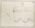
English: Index chart to the following survey of the coast of Karamania; made in pursuance of the orders of the Lords Commissioners of the Admiralty by Francis Beaufort F.R.S. Captain of His Majesty's Ship Frederikssteen. 1810-1811-1812 Single sheet. Engr. Scale: [ca.1:1 500 000]. Additional Places: Turkey. Contents Note: Shows the areas covered by the individual charts in the survey, with long-distance bearing lines, variation curves, prominent peaks and explanations of marks and symbols. Part of a presentation set in a soft paper cover. Title page inscribed 'V. Admiral Sir J.N. Norris from the Author'. |
| Date | 1819 |
| Dimensions | Printed area 60 x 75cm, on sheet 67 x 84cm. |
| Notes | Associated Materials: G235:8/6 to G235:8/15. |
| Source/Photographer | http://collections.rmg.co.uk/collections/objects/540831 |
| Permission (Reusing this file) |
The original artefact or artwork has been assessed as public domain by age, and faithful reproductions of the two dimensional work are also public domain. No permission is required for reuse for any purpose. The text of this image record has been derived from the Royal Museums Greenwich catalogue and image metadata. Individual data and facts such as date, author and title are not copyrightable, but reuse of longer descriptive text from the catalogue may not be considered fair use. Reuse of the text must be attributed to the "National Maritime Museum, Greenwich, London" and a Creative Commons CC-BY-NC-SA-3.0 license may apply if not rewritten. Refer to Royal Museums Greenwich copyright. |
| Other versions |
|
| Identifier | Acquisition Number: N1975-10 Admiralty Chart Number: 235 id number: G235:8/5 |
| Collection | Charts and maps |
Licensing
[edit]|
This is a faithful photographic reproduction of a two-dimensional, public domain work of art. The work of art itself is in the public domain for the following reason:
The official position taken by the Wikimedia Foundation is that "faithful reproductions of two-dimensional public domain works of art are public domain".
This photographic reproduction is therefore also considered to be in the public domain in the United States. In other jurisdictions, re-use of this content may be restricted; see Reuse of PD-Art photographs for details. | ||||
File history
Click on a date/time to view the file as it appeared at that time.
| Date/Time | Thumbnail | Dimensions | User | Comment | |
|---|---|---|---|---|---|
| current | 11:14, 5 September 2017 |  | 6,579 × 5,327 (100.27 MB) | Fæ (talk | contribs) | Royal Museums Greenwich Charts and maps, http://collections.rmg.co.uk/collections/objects/540831 #941-1 |
You cannot overwrite this file.
File usage on Commons
The following 3 pages use this file:
- File:Admiralty Chart No 235. Index chart to the following survey of the coast of Karamania; made in pursuance of the orders of the Lords Commissioners of the Admiralty by Francis Beaufort F.R.S. Captain of His Majesty's Ship Frederikssteen. RMG F8521.tiff
- File:Index chart to the following survey of the coast of Karamania; made in pursuance of the orders of the Lords Commissioners of the Admiralty by Francis Beaufort F.R.S. Captain of His Majesty's Ship Frederikssteen. RMG F0492.tiff
- File:Index chart to the following survey of the coast of Karamania; made in pursuance of the orders of the Lords Commissioners of the Admiralty by Francis Beaufort F.R.S. Captain of His Majesty's Ship Frederikssteen. RMG F8521.tiff (file redirect)