File:Airport diagram DSM.svg
Jump to navigation
Jump to search

Size of this PNG preview of this SVG file: 378 × 549 pixels. Other resolutions: 165 × 240 pixels | 330 × 480 pixels | 529 × 768 pixels | 705 × 1,024 pixels | 1,410 × 2,048 pixels.
Original file (SVG file, nominally 378 × 549 pixels, file size: 144 KB)
Captions
Captions
Add a one-line explanation of what this file represents
Summary
[edit]
| Description |
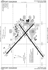
English: FAA diagram for Des Moines International Airport (IATA: DSM; ICAO: KDSM) in Des Moines, Iowa, United States. |
| Date | |
| Source |
Original: http://www.naco.faa.gov/d-tpp/0703/00117AD.PDF (effective 15 March 2007 to 12 April 2007). Note: this URL changes monthly, see airport article's external links for a link to the current FAA diagram. Derivative work: Own work in Inkscape based on original from FAA. See en:User:Cburnett/airport diagrams for information on how to convert PDF to SVG. |
| Author |
Original: National Aeronautical Charting Office (NACO), a department of the Federal Aviation Administration (FAA). Derivative work: en:User:Cburnett |
| Permission (Reusing this file) |
Original: Public Domain Derivative work: GFDL |
Licensing
[edit]
Original:
This image or file is a work of a Federal Aviation Administration employee, taken or made as part of that person's official duties. As a work of the U.S. federal government, the image is in the public domain in the United States.
|
 |
Derivative work:
I, the copyright holder of this work, hereby publish it under the following licenses:

|
Permission is granted to copy, distribute and/or modify this document under the terms of the GNU Free Documentation License, Version 1.2 or any later version published by the Free Software Foundation; with no Invariant Sections, no Front-Cover Texts, and no Back-Cover Texts. A copy of the license is included in the section entitled GNU Free Documentation License. |
| This file is licensed under the Creative Commons Attribution-Share Alike 3.0 Unported license. | ||
| ||
| This licensing tag was added to this file as part of the GFDL licensing update. |
You may select the license of your choice.
File history
Click on a date/time to view the file as it appeared at that time.
| Date/Time | Thumbnail | Dimensions | User | Comment | |
|---|---|---|---|---|---|
| current | 03:19, 3 April 2007 | | 378 × 549 (144 KB) | Cburnett (talk | contribs) | All white background |
| 03:17, 3 April 2007 |  | 378 × 549 (152 KB) | Cburnett (talk | contribs) | {{Information |Description={{en|Airport diagram of the Des Moines International Airport (IATA: DSM; ICAO: KDSM) in Des Moines, Iowa.}} |Source=Own work in Inkscape based on PDF [http://www. |
You cannot overwrite this file.
File usage on Commons
There are no pages that use this file.
File usage on other wikis
The following other wikis use this file:
- Usage on de.wikipedia.org
- Usage on en.wikipedia.org
- Usage on fr.wikipedia.org
- Usage on id.wikipedia.org
- Usage on ja.wikipedia.org
- Usage on ur.wikipedia.org
- Usage on vi.wikipedia.org
- Usage on zh.wikipedia.org