File:Americæ nova descriptio - impensis Anæ Seile; Rob. Vaughan sculp. NYPL1261568.tiff
Jump to navigation
Jump to search

Size of this JPG preview of this TIF file: 723 × 600 pixels. Other resolutions: 289 × 240 pixels | 579 × 480 pixels | 926 × 768 pixels | 1,235 × 1,024 pixels | 2,470 × 2,048 pixels | 4,435 × 3,678 pixels.
Original file (4,435 × 3,678 pixels, file size: 32.48 MB, MIME type: image/tiff)
Captions
Captions
Add a one-line explanation of what this file represents
Summary[edit]
| Description | Americæ nova descriptio / impensis Anæ Seile ; Rob. Vaughan sculp. | |||||||||||||||||||||||
| Alternate Title | Americae nova descriptio. | |||||||||||||||||||||||
| Notes | Relief shown pictorially. Note 2.) A re-engraved version of a map previously published for Henri Seile in 1652 under the title "Americae descriptio nova" and subsequently re-published from the same engraving as the 1652 map for Phillippi Chetwood in 1666. Note 3.) Appears in Peter Heylyn's "Cosmography in four books", 1677. Note 4.) Watermarks. Note 5.) National Endowment for the Humanities Grant for Access to Early Maps of the Middle Atlantic Seaboard. | |||||||||||||||||||||||
| Physical description | 1 map : hand col. ; 34 x 41 cm. | |||||||||||||||||||||||
| Catalog Call Number | Map Div. 90-7627 | |||||||||||||||||||||||
| Date | ||||||||||||||||||||||||
| Source |
http://digitalgallery.nypl.org/nypldigital/dgkeysearchdetail.cfm?imageID=1261568
|
|||||||||||||||||||||||
| Author | Heylyn, Peter, 1600-1662 -- CartographerSeile, Henricus -- Publisher ;Seile, Anne, 1678 -- Publisher | |||||||||||||||||||||||
| Permission (Reusing this file) |
From The Lionel Pincus & Princess Firyal Map Division. Released on a CC0 license.[1] | |||||||||||||||||||||||
| Digital ID | 1261568 | |||||||||||||||||||||||
| Location | Stephen A. Schwarzman Building / The Lionel Pincus and Princess Firyal Map Division | |||||||||||||||||||||||
| NYPL digital item published | 3-23-2005; updated 3-25-2011 | |||||||||||||||||||||||

Licensing[edit]
| This file is made available under the Creative Commons CC0 1.0 Universal Public Domain Dedication. | |
| The person who associated a work with this deed has dedicated the work to the public domain by waiving all of their rights to the work worldwide under copyright law, including all related and neighboring rights, to the extent allowed by law. You can copy, modify, distribute and perform the work, even for commercial purposes, all without asking permission.
|
The making of this file was supported by Wikimedia UK.
To see other files made with the support of Wikimedia UK, please see the category Supported by Wikimedia UK.
|
File history
Click on a date/time to view the file as it appeared at that time.
| Date/Time | Thumbnail | Dimensions | User | Comment | |
|---|---|---|---|---|---|
| current | 22:25, 3 May 2014 | 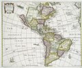 | 4,435 × 3,678 (32.48 MB) | Fæ (talk | contribs) | crop (uploaded using chunked upload script) |
| 17:55, 28 April 2014 |  | 5,027 × 4,576 (41.64 MB) | Finavon (talk | contribs) | rotated | |
| 22:10, 4 April 2014 |  | 4,576 × 5,027 (65.82 MB) | Fæ (talk | contribs) | =={{int:filedesc}}== {{NYPL_map |record_id = 614563 |specific_material_type = Maps |digital_id = 1261568 |medium = Engravings |additional_names = Seile, Henricus -- Publisher ;Seile, Anne, 1678 -- Publisher |catalog_call_number = Map Div. 90-7627 |crea... |
You cannot overwrite this file.
File usage on Commons
The following 3 pages use this file: