File:Antarctic Peninsula ice flow ESA360217.tiff

Original file (2,855 × 2,561 pixels, file size: 4.84 MB, MIME type: image/tiff)
Captions
Captions
Summary[edit]
| Description |
English: Successive radar images captured by the Copernicus Sentinel-1A satellite during December 2014 – March 2016 were used to create this spectacular map showing how fast the ice flows on the Antarctic Peninsula. The map was constructed by tracking the movement of ice features in pairs of radar images taken 12 days apart.
The Antarctic Peninsula is a narrow mountainous finger or spine of land extending northwards away from the Central Antarctic ice sheet (lower right corner) and comprises the northernmost arm of the Antarctic ice sheet. The colour scale indicates the speed of ice movement in metres per day, ranging from 1 centimetre per day or less in dark blue to up to 1 metre per day in red. The vivid colours trace a complex network of channels along which streams of ice flow from the high mountains down towards the coast where the ice flow speeds up and spreads out into floating ice shelves. The white area on the western flank of the peninsula is where snowfall is likely to have concealed features and so prevented tracking between the image pairs. As one of the most dynamic glacial environments on Earth, this region has been experiencing rapid climate warming over recent decades. Since 1991, satellites such as ESA’s ERS and Envisat have observed the disintegration of various ice shelves, including the northern portion of the Larsen ice shelf and the Wilkins ice shelf. The Sentinel satellites, developed by ESA, are central to Europe’s environmental monitoring Copernicus programme, which is committed to long-term operational services for a wide range of applications. This example shows the spectacular potential of the Sentinel-1 mission for routine mapping and monitoring the surface velocity of glaciers and ice sheets. The combination of Sentinel-1A and -1B will support comprehensive and long-term monitoring of changes in ice sheet velocity and how they respond to climate change. The Sentinel-1 ice velocity product was presented at ESA’s Living Planet Symposium in Prague, Czech Republic in May 2016 and three weeks earlier at the European Geosciences Union General Assembly in Austria. Nagler T., Rott H., Hetzenecker M., Wuite J. (2016) Monitoring ice motion of the Antarctic and Greenland ice sheets at high spatial and temporal resolution by means of Sentinel-1 SAR. Living Planet Symposium, Abstract. ESA 2016. Wuite, J., Nagler, T., Hetzenecker, M., Blumthaler, U., Rott, H. (2016): Continuous monitoring of Greenland and Antarctic ice sheet velocities using Sentinel-1 SAR. Geophysical Research Abstracts, Vol. 18, EGU2016 –12826, 2016. |
| Date | |
| Source | http://www.esa.int/spaceinimages/Images/2016/05/Antarctic_Peninsula_ice_flow |
| Author | European Space Agency |
| Permission (Reusing this file) |
contains modified Copernicus Sentinel data (2015), processed by Enveo,CC BY-SA 3.0 IGO |
| Other versions |
|
| Title | Antarctic Peninsula ice flow |
| Set | Living Planet Symposium 2016 |
| Mission | Sentinel-1 |
| Activity | Observing the Earth |

Licensing[edit]
- You are free:
- to share – to copy, distribute and transmit the work
- to remix – to adapt the work
- Under the following conditions:
- attribution – You must give appropriate credit, provide a link to the license, and indicate if changes were made. You may do so in any reasonable manner, but not in any way that suggests the licensor endorses you or your use.
- share alike – If you remix, transform, or build upon the material, you must distribute your contributions under the same or compatible license as the original.

|
This image contains data from a satellite in the Copernicus Programme, such as Sentinel-1, Sentinel-2 or Sentinel-3. Attribution is required when using this image.
Attribution: Contains modified Copernicus Sentinel data {{{year}}}
The use of Copernicus Sentinel Data is regulated under EU law (Commission Delegated Regulation (EU) No 1159/2013 and Regulation (EU) No 377/2014). Relevant excerpts:
Free access shall be given to GMES dedicated data [...] made available through GMES dissemination platforms [...].
Access to GMES dedicated data [...] shall be given for the purpose of the following use in so far as it is lawful:
GMES dedicated data [...] may be used worldwide without limitations in time.
GMES dedicated data and GMES service information are provided to users without any express or implied warranty, including as regards quality and suitability for any purpose. |
File history
Click on a date/time to view the file as it appeared at that time.
| Date/Time | Thumbnail | Dimensions | User | Comment | |
|---|---|---|---|---|---|
| current | 13:26, 7 May 2017 | 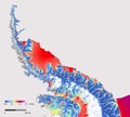 | 2,855 × 2,561 (4.84 MB) | Fæ (talk | contribs) | == {{int:filedesc}} == {{information | description = {{en|1=Successive radar images captured by the Copernicus Sentinel-1A satellite during December 2014 – March 2016 were used to create this spectacular map showing how fast the ice flows on the Anta... |
You cannot overwrite this file.
File usage on Commons
The following 2 pages use this file:
File usage on other wikis
The following other wikis use this file:
- Usage on en.wikipedia.org