File:Athabasca Rail at Brule Lake.jpg
Jump to navigation
Jump to search

Size of this preview: 800 × 532 pixels. Other resolutions: 320 × 213 pixels | 640 × 426 pixels | 1,024 × 681 pixels | 1,280 × 852 pixels | 2,560 × 1,704 pixels | 4,496 × 2,992 pixels.
Original file (4,496 × 2,992 pixels, file size: 2.01 MB, MIME type: image/jpeg)
Captions
Captions
Add a one-line explanation of what this file represents
Summary[edit]
| Description |
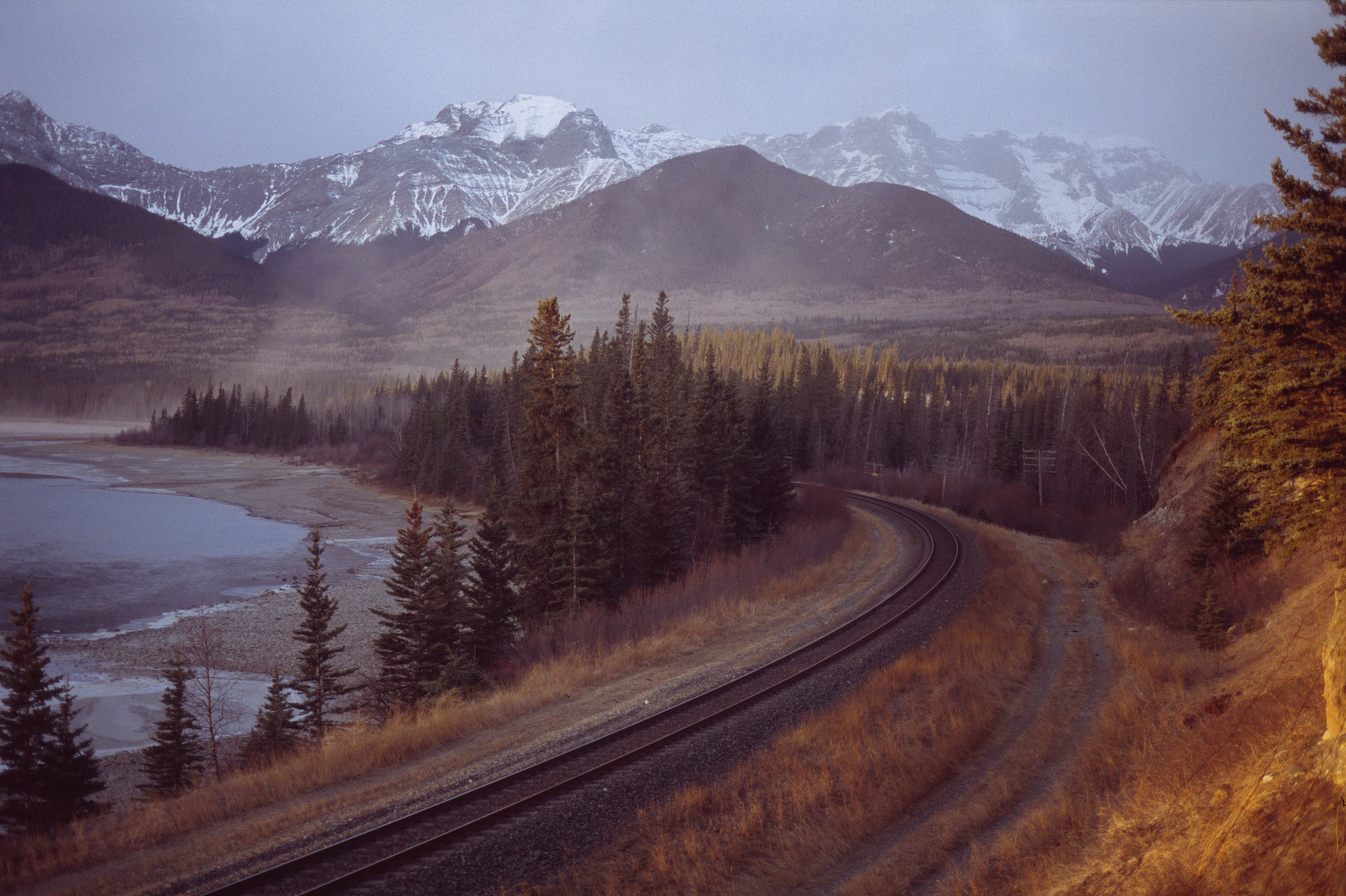
Español: El río Athabasca y el ferrocarril cerca de la desembocadura del Lago Brule de Alberta, Canadá. Français : La Rivière Athabasca et la voie ferrée près de l'embouchure du Lac Brule en Alberta au Canada. Galego: A vía do tren á beira do río Athabasca xunto ao lago Brule en Alberta, Canadá en xaneiro de 2006. Русский: Железная дорога вдоль реки Атабаска у озера Брюль (Brule Lake) в Альберте в Канаде, в бесснежную зиму ಕನ್ನಡ : ಕೆನಡಾದ ಅಲ್ಬೆರ್ಟಾದಲ್ಲಿರುವ ಬ್ಲ್ಯೂ ಲೇಕ್ ಬಳಿಯಿರುವ ಅಥಬಾಸ್ಕಾ ನದಿ ರೇಲ್ ರೋಡ್ ದೃಶ್ಯ. العربية : مسار السكه الحديديه عند نهر اثاباسكا عند مدخل بحيره برولي في البرتا بكندا. |
| Date | |
| Source | Eddie Carle |
| Author | Eddie Carle |
| Camera location | | View this and other nearby images on: OpenStreetMap |
|---|
Licensing[edit]
Eddie Carle, the copyright holder of this work, hereby publishes it under the following licenses:

|
Permission is granted to copy, distribute and/or modify this document under the terms of the GNU Free Documentation License, Version 1.2 or any later version published by the Free Software Foundation; with no Invariant Sections, no Front-Cover Texts, and no Back-Cover Texts. A copy of the license is included in the section entitled GNU Free Documentation License. |
| This file is licensed under the Creative Commons Attribution-Share Alike 3.0 Unported license. | ||
| Attribution: Eddie Carle | ||
| ||
| This licensing tag was added to this file as part of the GFDL licensing update. |
This file is licensed under the Creative Commons Attribution 2.5 Generic license.
Attribution: Eddie Carle
- You are free:
- to share – to copy, distribute and transmit the work
- to remix – to adapt the work
- Under the following conditions:
- attribution – You must give appropriate credit, provide a link to the license, and indicate if changes were made. You may do so in any reasonable manner, but not in any way that suggests the licensor endorses you or your use.
You may select the license of your choice.
Assessment[edit]
|

This image was selected as picture of the day on Wikimedia Commons for 5 August 2006. It was captioned as follows: Other languages:
Cymraeg: Cledrau'r rheilffordd yr Afon Athabasca wrth gêg Llyn Brule yn Alberta, Canada. Español: El río Athabasca y el ferrocarril cerca de la desembocadura del Lago Brule de Alberta, Canadá. Français : La rivière Athabasca et la voie ferrée près de l'embouchure du Lac Brule de Alberta, Canada. Galego: A vía do tren á beira do río Athabasca xunto ao lago Brule en Alberta, Canadá en xaneiro de 2006. Magyar: Az Athabasca folyó menti vasútvonal az albertai Brule-tónál, Kanadában. Português: Ferrovia do Rio Athabasca junto ao Lago Brule (Alberta, Canadá) Suomi: Athabascajoen junarata Brule Laken suulla Albertassa, Kanadassa. Русский: Железная дорога вдоль реки Атабаска у озера Брюль (Brule Lake) в Альберте в Канаде, в бесснежную зиму ಕನ್ನಡ : ಕೆನಡಾದ ಅಲ್ಬೆರ್ಟಾದಲ್ಲಿರುವ ಬ್ಲ್ಯೂ ಲೇಕ್ ಬಳಿಯಿರುವ ಅಥಬಾಸ್ಕಾ ನದಿ ರೇಲ್ ರೋಡ್ ದೃಶ್ಯ. العربية : مسار السكك الحديدية عند نهر أثاباسكا عند مدخل بحيرة برولي في ألبرتا بكندا. |
File history
Click on a date/time to view the file as it appeared at that time.
| Date/Time | Thumbnail | Dimensions | User | Comment | |
|---|---|---|---|---|---|
| current | 17:56, 20 April 2006 | | 4,496 × 2,992 (2.01 MB) | Anomity (talk | contribs) | == Summary == The Athabasca Rivers' rail track at the mouth of Brule Lake The image copyright owner, Eddie Carle, hereby agrees to the licensing terms of the GFDL for use on WikiMedia Commons. The owner, Eddie Carle, retains copyright to this im |
You cannot overwrite this file.
File usage on Commons
The following 43 pages use this file:
- Athabasca River
- Railroad
- User:Anomity
- User:AzaToth/Nature
- User:Dschwen/FP2006
- User:Kstigarbha/gallery
- Commons:Featured picture candidates/Image:Athabasca Rail at Brule Lake.jpg
- Commons:Featured picture candidates/Log/June 2006
- Commons:Featured picture candidates/Log/March 2012
- Commons:Featured picture candidates/removal/File:Athabasca Rail at Brule Lake.jpg
- Commons:Featured pictures/chronological/2006-A
- Commons:Picture of the Year/2006/gallery
- Commons:Picture of the Year/2006/gallery0
- Commons:Picture of the Year/2006/gallery large
- Commons:Potd/2006-08 (fr)
- Commons:Potd/2006-08 (pl)
- Commons:Potd/2006-08 (pt)
- Commons:Potd/2006-08 (sv)
- Commons:Potd/2006-08 (tr)
- Commons talk:Featured picture candidates/Archive candidate list
- Template:Potd/2006-08
- Template:Potd/2006-08-05
- Template:Potd/2006-08-05 (ar)
- Template:Potd/2006-08-05 (cy)
- Template:Potd/2006-08-05 (de)
- Template:Potd/2006-08-05 (en)
- Template:Potd/2006-08-05 (es)
- Template:Potd/2006-08-05 (fi)
- Template:Potd/2006-08-05 (fr)
- Template:Potd/2006-08-05 (ga)
- Template:Potd/2006-08-05 (gl)
- Template:Potd/2006-08-05 (hu)
- Template:Potd/2006-08-05 (it)
- Template:Potd/2006-08-05 (ja)
- Template:Potd/2006-08-05 (kn)
- Template:Potd/2006-08-05 (nb)
- Template:Potd/2006-08-05 (nn)
- Template:Potd/2006-08-05 (pl)
- Template:Potd/2006-08-05 (pt)
- Template:Potd/2006-08-05 (ru)
- Template:Potd/2006-08-05 (sk)
- Template:Potd/2006-08-05 (sv)
- Template:Potd/2006-08-05 (zh-hans)
File usage on other wikis
The following other wikis use this file:
- Usage on ca.wikipedia.org
- Usage on de.wikipedia.org
- Usage on el.wiktionary.org
- Usage on en.wikipedia.org
- Usage on fi.wikipedia.org
- Usage on fr.wikipedia.org
- Usage on hu.wikipedia.org
- Usage on ia.wikipedia.org
- Usage on id.wikipedia.org
- Usage on it.wikipedia.org
- Usage on ko.wikipedia.org
- Usage on nl.wikipedia.org
- Usage on os.wikipedia.org
- Usage on pl.wikipedia.org
- Usage on pt.wikipedia.org
- Usage on ru.wikipedia.org
- Usage on ru.wikinews.org
- Usage on sr.wikipedia.org
- Usage on sv.wikipedia.org
- Usage on uk.wikipedia.org
- Usage on uz.wikipedia.org