File:Bad Bleiberg - Sender Dobratsch.JPG
Jump to navigation
Jump to search

Size of this preview: 400 × 600 pixels. Other resolutions: 160 × 240 pixels | 320 × 480 pixels | 512 × 768 pixels | 682 × 1,024 pixels | 1,365 × 2,048 pixels | 2,600 × 3,900 pixels.
Original file (2,600 × 3,900 pixels, file size: 9.14 MB, MIME type: image/jpeg)
Captions
Captions
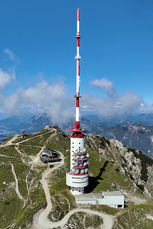
Southeast view of the Dobratsch Transmitter Tower in Carinthia.
Summary[edit]
| Description |
Deutsch: Südostansicht des Senders Dobratsch auf dem 2166 m hohen Dobratsch in der Kärntner Marktgemeinde Bad Bleiberg und direkt links dahinter das Dobratsch-Gipfelhaus. Noch weiter hinten befindet sich die Windische Kapelle (auf dem Gemeindegebiet von Nötsch im Gailtal), sowie das Gipfelkreuz.
Der Sender mit einem 167 m hohen Turm wurde nach 2 Jahren Bauzeit am 15. Oktober 1971 eröffnet. Zuvor benutzte man eine Sendeanlage auf dem Pyramidenkogel südlich des Wörthersees, die aber für die befriedigende Versorgung von Kärnten zu niedrig lag. Damit der Sender ganzjährig erreichbar ist, wurde eine eigene Seilbahn installiert, die von Bad Bleiberg direkt zum Sender führt: [1]. Diese ist jedoch nicht öffentlich zugänglich. English: Southeast view of the Dobratsch Transmitter Tower in Carinthia. |
| Date | |
| Source | Own work |
| Author | C.Stadler/Bwag |
| Permission (Reusing this file) |
Deutsch: Hallo, du darfst mein Foto kostenlos nutzen, aber nenne mich bitte als Fotograf, beispielsweise „Foto: C.Stadler/Bwag“ oder © C.Stadler/Bwag; CC-BY-SA-4.0. Auf mehr Angaben bestehe ich nicht - im Gegensatz zu manch anderen, die die Vorgaben der unten angeführten Lizenzierung auf Punkt und Beistrich einfordern. English: Feel free to use my photos, but please mention me as the author like © C.Stadler/Bwag or © C.Stadler/Bwag; CC-BY-SA-4.0 (that's good enough) and if you want send me a message: bwag@gmx.net. |
| Object location | | View this and other nearby images on: OpenStreetMap |
|---|
| Camera location | | View this and other nearby images on: OpenStreetMap |
|---|
Licensing[edit]
I, the copyright holder of this work, hereby publish it under the following license:
This file is licensed under the Creative Commons Attribution-Share Alike 4.0 International license.
- You are free:
- to share – to copy, distribute and transmit the work
- to remix – to adapt the work
- Under the following conditions:
- attribution – You must give appropriate credit, provide a link to the license, and indicate if changes were made. You may do so in any reasonable manner, but not in any way that suggests the licensor endorses you or your use.
- share alike – If you remix, transform, or build upon the material, you must distribute your contributions under the same or compatible license as the original.
File history
Click on a date/time to view the file as it appeared at that time.
| Date/Time | Thumbnail | Dimensions | User | Comment | |
|---|---|---|---|---|---|
| current | 21:42, 6 September 2022 | | 2,600 × 3,900 (9.14 MB) | Bwag (talk | contribs) | wb |
| 21:31, 6 September 2022 |  | 2,600 × 3,900 (5.79 MB) | Bwag (talk | contribs) | == {{int:filedesc}} == {{Information |Description= {{de|1= Südostansicht des Senders Dobratsch auf dem 2166 m hohen Dobratsch in der Kärntner Marktgemeinde Bad Bleiberg und direkt links dahinter das ''Dobratsch-Gipfelhaus''. Noch weiter hinten befindet sich die ''Windische Kapelle'' (auf dem Gemeindegebiet von Nötsch im Gailtal), sowie das Gipfelkreuz.<br/>Der Sender mit einem 167 m hohen Turm wurde nach 2 Jahren Bauzeit am 15. Oktober 1971 eröffnet. Damit der Sender ganzjährig erreichbar ist... |
You cannot overwrite this file.
File usage on Commons
The following 2 pages use this file:
File usage on other wikis
The following other wikis use this file:
- Usage on de.wikipedia.org
- Usage on www.wikidata.org