File:CLOSE UP OF JUNCTION AT CONCRETE SPAN AND TRUSS SPAN. TAKEN FROM NORTHEAST SIDE OF BRIDGE ON EASTERN BANK OF CREEK. - Road S-1-133 Bridge, Spanning Long Cane Creek, Abbeville, Abbeville HAER SC-26-6.tif
Jump to navigation
Jump to search

Size of this JPG preview of this TIF file: 483 × 599 pixels. Other resolutions: 193 × 240 pixels | 387 × 480 pixels | 619 × 768 pixels | 825 × 1,024 pixels | 1,651 × 2,048 pixels | 4,230 × 5,247 pixels.
Original file (4,230 × 5,247 pixels, file size: 21.17 MB, MIME type: image/tiff)
Captions
Captions
Add a one-line explanation of what this file represents
Summary[edit]
| CLOSE UP OF JUNCTION AT CONCRETE SPAN AND TRUSS SPAN. TAKEN FROM NORTHEAST SIDE OF BRIDGE ON EASTERN BANK OF CREEK. - Road S-1-133 Bridge, Spanning Long Cane Creek, Abbeville, Abbeville County, SC | ||||
|---|---|---|---|---|
| Photographer |
Moore, Wayne |
|||
| Title |
CLOSE UP OF JUNCTION AT CONCRETE SPAN AND TRUSS SPAN. TAKEN FROM NORTHEAST SIDE OF BRIDGE ON EASTERN BANK OF CREEK. - Road S-1-133 Bridge, Spanning Long Cane Creek, Abbeville, Abbeville County, SC |
|||
| Description |
South Carolina Highway Department; South Carolina Department of Transportation; Calloway, Deborah, transmitter; South Carolina Department of Transportation, sponsor; Federal Highway Administration, sponsor |
|||
| Depicted place | South Carolina; Abbeville County; Abbeville | |||
| Date | 1998 | |||
| Dimensions | 4 x 5 in. | |||
| Current location |
Library of Congress Prints and Photographs Division Washington, D.C. 20540 USA http://hdl.loc.gov/loc.pnp/pp.print |
|||
| Accession number |
HAER SC-26-6 |
|||
| Credit line |
|
|||
| Notes |
|
|||
| Source | https://www.loc.gov/pictures/item/sc0930.photos.203126p | |||
| Permission (Reusing this file) |
|
|||

| Object location | | View this and other nearby images on: OpenStreetMap |
|---|
File history
Click on a date/time to view the file as it appeared at that time.
| Date/Time | Thumbnail | Dimensions | User | Comment | |
|---|---|---|---|---|---|
| current | 20:26, 1 August 2014 | 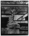 | 4,230 × 5,247 (21.17 MB) | Fæ (talk | contribs) | GWToolset: Creating mediafile for Fæ. HABS 2014-08-01 (3201:3400) |
You cannot overwrite this file.
File usage on Commons
The following page uses this file: