File:Carte des terroirs de bagadoù lors du concours 2008.svg
Jump to navigation
Jump to search

Size of this PNG preview of this SVG file: 800 × 591 pixels. Other resolutions: 320 × 236 pixels | 640 × 473 pixels | 1,024 × 756 pixels | 1,280 × 946 pixels | 2,560 × 1,891 pixels | 1,064 × 786 pixels.
Original file (SVG file, nominally 1,064 × 786 pixels, file size: 168 KB)
Captions
Captions
Add a one-line explanation of what this file represents
Summary[edit]
| Description |
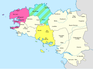
English: Rough map of the bagadoù areas in Brittany, for the 2008 contests.
First category
Second category
Third category
Fourth category Français : Carte approximative des terroirs de bagadoù en Bretagne, pour le concours 2008.
Première categorie
Seconds categorie
Troisième categorie
Quatrième categorie |
||
| Date | (UTC) | ||
| Source |
|
||
| Author | Sémhur (talk) | ||
| Other versions |
| ||
| Attribution (required by the license) | © Sémhur / Wikimedia Commons / | ||
| SVG | W3C-validity not checked.
|
||
| Graphic Lab |

| Object location | | View this and other nearby images on: OpenStreetMap |
|---|
Licensing[edit]
I, the copyright holder of this work, hereby publish it under the following licenses:
| Copyleft: This work of art is free; you can redistribute it and/or modify it according to terms of the Free Art License. You will find a specimen of this license on the Copyleft Attitude site as well as on other sites. |
This file is licensed under the Creative Commons Attribution-Share Alike 4.0 International, 3.0 Unported, 2.5 Generic, 2.0 Generic and 1.0 Generic license.
- You are free:
- to share – to copy, distribute and transmit the work
- to remix – to adapt the work
- Under the following conditions:
- attribution – You must give appropriate credit, provide a link to the license, and indicate if changes were made. You may do so in any reasonable manner, but not in any way that suggests the licensor endorses you or your use.
- share alike – If you remix, transform, or build upon the material, you must distribute your contributions under the same or compatible license as the original.
You may select the license of your choice.
File history
Click on a date/time to view the file as it appeared at that time.
| Date/Time | Thumbnail | Dimensions | User | Comment | |
|---|---|---|---|---|---|
| current | 08:38, 28 December 2014 | | 1,064 × 786 (168 KB) | Sémhur (talk | contribs) | Nimbus Sans L |
| 08:36, 28 December 2014 |  | 1,064 × 786 (167 KB) | Sémhur (talk | contribs) | + Noms des terroirs | |
| 12:48, 24 December 2014 |  | 1,064 × 786 (143 KB) | Sémhur (talk | contribs) | Hachures plus larges | |
| 09:33, 24 December 2014 |  | 1,064 × 786 (143 KB) | Sémhur (talk | contribs) | Nouvelles couleurs | |
| 11:57, 23 December 2014 |  | 1,064 × 786 (132 KB) | Sémhur (talk | contribs) | + Pourlet - Bro Pondi - Bro Wened et Bro Dreger - Fañch - Goueloù. | |
| 21:08, 22 December 2014 |  | 1,064 × 786 (131 KB) | Sémhur (talk | contribs) | == {{int:filedesc}} == {{Information |Description={{Multilingual description |en= Rough map of the bagadoù areas in North-West Brittany, for the 2008-2015 cycle of contests: Pagan - Bro Léon - Plougastell - Kernevodez - Penn Sardin - Br... |
You cannot overwrite this file.
File usage on Commons
The following 2 pages use this file:
- File:Carte des terroirs de bagadou - concours 2008.svg (file redirect)
- File:Carte des terroirs de bagadou Nord-Ouest Bretagne.svg (file redirect)
File usage on other wikis
The following other wikis use this file:
- Usage on fr.wikipedia.org