File:Carte reduite des costes de France de Portugal et d'Espagne sur l'Ocean et sur la Mediterranee pour la traversee des vaisseaux du Roi de Brest a Toulon RMG F0125.tiff
Original file (6,777 × 5,318 pixels, file size: 103.11 MB, MIME type: image/tiff)
Captions
Captions
Summary[edit]
| Author |
Jacques Nicolas Bellin |
| Description |
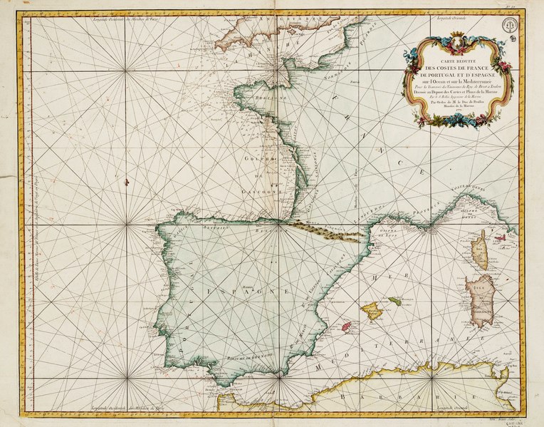
English: Carte reduite des costes de France de Portugal et d'Espagne sur l'Ocean et sur la Mediterranee pour la traversee des vaisseaux du Roi de Brest a ToulonSingle sheet, hand coloured engraving. Scale [circa 1:3,000,000]. The scale is in French and English marine leagues.The borders are graduated for latitude and longitude with Paris as the prime meridian. Rhumb lines. The price of the chart is printed at the foot: Prix trente sols.
The chart is annotated with manuscript tracks of HMS Leviathan, one of the ships which took part in the Battle of the Glorious First of June (1794): a) red ink for 11-23 Jan 1794, b) brown dots for 5 May - 20 June 1794, c) brown continuous line for 5-20 Feb 1795. |
| Date | 1771 |
| Dimensions | Printed area 62.5 x 78cm, on sheet 66.5 x 84.5cm |
| Source/Photographer | http://collections.rmg.co.uk/collections/objects/540241 |
| Permission (Reusing this file) |
The original artefact or artwork has been assessed as public domain by age, and faithful reproductions of the two dimensional work are also public domain. No permission is required for reuse for any purpose. The text of this image record has been derived from the Royal Museums Greenwich catalogue and image metadata. Individual data and facts such as date, author and title are not copyrightable, but reuse of longer descriptive text from the catalogue may not be considered fair use. Reuse of the text must be attributed to the "National Maritime Museum, Greenwich, London" and a Creative Commons CC-BY-NC-SA-3.0 license may apply if not rewritten. Refer to Royal Museums Greenwich copyright. |
| Identifier | Acquisition Number: N1983 - 6 id number: G215:1/22 |
| Collection | Charts and maps |
Licensing[edit]
|
This is a faithful photographic reproduction of a two-dimensional, public domain work of art. The work of art itself is in the public domain for the following reason:
The official position taken by the Wikimedia Foundation is that "faithful reproductions of two-dimensional public domain works of art are public domain".
This photographic reproduction is therefore also considered to be in the public domain in the United States. In other jurisdictions, re-use of this content may be restricted; see Reuse of PD-Art photographs for details. | ||||
File history
Click on a date/time to view the file as it appeared at that time.
| Date/Time | Thumbnail | Dimensions | User | Comment | |
|---|---|---|---|---|---|
| current | 11:36, 17 August 2017 |  | 6,777 × 5,318 (103.11 MB) | Fæ (talk | contribs) | Royal Museums Greenwich Charts and maps, http://collections.rmg.co.uk/collections/objects/540241 |
You cannot overwrite this file.
File usage on Commons
The following page uses this file: