File:Central-Afrika nach den neuesten Forschungen bearbeitet - Joseph Chavanne.png
Jump to navigation
Jump to search

Size of this preview: 800 × 553 pixels. Other resolutions: 320 × 221 pixels | 640 × 442 pixels | 1,024 × 708 pixels | 1,280 × 884 pixels | 1,482 × 1,024 pixels.
Original file (1,482 × 1,024 pixels, file size: 3.05 MB, MIME type: image/png)
Captions
Captions
Add a one-line explanation of what this file represents

|
This file has been superseded by Central-Afrika nach den neuesten Forschungen bearbeitet - Joseph Chavanne.jpg. It is recommended to use the other file. Please note that deleting superseded images requires consent.
|

|
Summary[edit]
| Author |
Русский: Шаванн, Йозеф
Français : Chavanne, Joseph
English: Chavanne, Joseph
中文:莎瓦纳, 约瑟夫
Português: Chavanne, Joseph
العربية: شافان, جوزيف
Español: Chavanne, Joseph |
| Title |
Русский: Центральная Африка после новейших исследований
Français : Afrique centrale après de récentes recherches
English: Central Africa after the Newest Research
中文:最新研究的非洲中部
Português: África Central após a mais nova pesquisa
العربية: افريقيا الوسطى بعد أحدث البحوث
Español: África central después de la última investigación |
| Description |
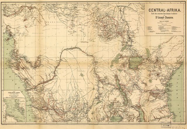
Русский: Карта центральной части Африки, составленная д-ром Жозефом Шаванье, вероятнее всего, в начале 1880-х гг., вышла в свет в результате начавшейся в Европе "схватки за Африку". Хотя голландцы и португальцы основали торговые порты и фактории вдоль побережий Африки еще в конце V века, основная борьба между европейскими странами за право владения обширными африканскими территориями, расположенными к югу от Сахары, разгорелась в конце XIX века. Бельгия, Великобритания, Франция и Германия заявляли свои права на обширные территории, основывая свои претензии на открытиях путешественников и исследователей, экспедиции которых были документально запечатлены Шаванье. Шаванье, родившийся в Вене, по праву считался выдающимся географом и путешественником. Его работы вызвали восхищение в Европе не только благодаря его географическим познаниям и искусству картографа, но также и благодаря его глубокому пониманию этнографии, почерпнутое им во время его путешествий. Шаванье продолжал работать над составлением карт центральной части Африки, концентрируя свои усилия на подробной карте всего региона Конго.
Африка, Центральная Français : La carte de l'Afrique centrale du Dr. Joseph Chavanne, très probablement créée au début des années 1880, est un produit de la « ruée sur l'Afrique » des Européens. Bien que les Néerlandais et les Portugais aient établi des comptoirs commerciaux le long des côtes de l'Afrique dès la fin du XVe siècle, la course européenne pour acquérir de vastes étendues de territoire en Afrique subsaharienne ne commença sérieusement qu'à la fin du XIXe siècle. La Belgique, la Grande-Bretagne, la France et l'Allemagne formulèrent toutes des revendications rivales, basées sur les découvertes d'explorateurs qui s'étaient rendus à l'intérieur du continent et dont Chavanne illustre les expéditions. Originaire de Vienne, Chavanne était lui-même à la fois géographe et voyageur. On admirait son travail en Europe, non seulement pour ses connaissances géographiques et ses compétences cartographiques, mais aussi pour les observations ethnographiques qu'il tira de ses propres voyages. Chavanne poursuivit ses travaux sur l'Afrique centrale avec la réalisation d'une carte plus approfondie de toute la région du Congo.
Afrique centrale English: Dr. Joseph Chavanne’s map of central Africa, most likely created in the early 1880s, is a product of the European imperial “scramble for Africa.” Although the Dutch and Portuguese established trading posts along the coasts of Africa as early as the late 15th century, the European race to claim significant tracts of territory in sub-Saharan Africa began in earnest only in the late 19th century. Belgium, Britain, France, and Germany all carved out competing claims, based on the discoveries of inland explorers whose expeditions Chavanne documents. Originally from Vienna, Chavanne was both a geographer and a traveler in his own right. His work was admired in Europe not only for his geographic knowledge and cartographic skill but for the ethnographic insights he drew from his own travels. Chavanne continued his work on central Africa with more extensive mapping of the entire Congo region.
Africa, Central 中文:这幅约瑟夫·查凡内的中部非洲地图可能创作于 19 世纪 80 年代早期,是欧洲帝国“争夺非洲”的产物。 尽管荷兰和葡萄牙早在 15 世纪后期就在非洲沿海建立了贸易站,但欧洲对撒哈拉以南非洲土地的争夺赛直到 19 世纪后期才真正开始。 比利时、英国、法国和德国都根据查凡内所记录的内陆探险家的发现,提出了各自相互竞争的领土要求。 原自维也纳的查凡内,凭借自己的能力成为了一名地理学家和旅行家。 欧洲人对他作品的欣赏不仅是因为他的地理知识和制图技能,而是他从自身的旅行中所感悟出的人种方面的深刻见解。 查凡内继续研究中部非洲的工作,绘制了整个刚果地区涵盖面积更大的地图。
中非 Português: O mapa da África Central do Dr. Joseph Chavanne, provavelmente elaborado no início dos anos 1880, é produto da "corrida pela África" na Europa imperial. Embora os holandeses e portugueses estabelecessem postos comerciais ao longo do litoral da África no fim do século XV, a corrida europeia para reivindicar significativas extensões de território na África sub-saariana começou, mais seriamente, somente no final do século XIX. Bélgica, Grã-Bretanha, França e Alemanha estabeleceram reivindicações semelhantes, baseadas na descoberta de desbravadores cujas expedições Chavanne documenta. Oriundo de Viena, Chavanne era geógrafo e viajante legitimado. Sua obra era admirada na Europa, não apenas por seu conhecimento geográfico e pela sua habilidade cartográfica, mas pelas percepções etnográficas que ele obtivera de suas próprias viagens. Chavanne continuou seu trabalho na África Central, com um mapeamento mais extenso de toda a região do Congo.
África, Central العربية: إن الخريطة
التي وضعها الدكتور جوزيف شافان لوسط أفريقيا في أوائل الثمانينات من القرن التاسع عشر نتجت عن "التزاحم على أفريقيا" الذي اتسم به العصر الإمبراطوري الأوروبي. على الرغم من أن الهولنديين والبرتغاليين أنشأوا محطات للتجارة على طول السواحل الأفريقية في وقت مبكر منذ أواخر القرن الخامس عشر، لم يبدأ الأوروبيون سباقهم على المطالبة بمساحات كبيرة من الأراضي الأفريقية جنوب الصحراء الكبرى بصورة جدية حتى أواخر القرن التاسع عشر.
وقدمت كل من بلجيكا وبريطانيا وفرنسا وألمانيا مطالبات على أساس الاكتشافات الداخلية التي قام بها المستكشفون والتي دوّنها شافان. وهو أصلا من فيينا، وكان جغرافيًا ورحالة في حد ذاته.
لقى عمله إعجابا في أوروبا ليس لمعرفته الجغرافية ومهارته في رسم الخرائط فحسب، ولكن لبصيرته الإثنوغرافية التي كسبها من رحلاته الشخصية. واصل شافان عمله عن وسط أفريقيا بمنتوج خرائطي موسع لمنطقة الكونغو.
أفريقيا، الوسطى Español: El mapa de África central del Dr. Joseph Chavanne, probablemente de principios de la década de 1880, es resultado de la «disputa por África» imperial europea. Aunque los holandeses y los portugueses tenían establecidos puestos comerciales a lo largo de las costas africanas desde finales del siglo XV, la carrera europea por reclamar extensiones importantes de territorio en el África subsahariana no empezó realmente hasta finales del siglo XIX. Bélgica, Gran Bretaña, Francia y Alemania sostenían las mismas demandas sobre territorios, basándose en los descubrimientos de los exploradores de las tierras interiores, cuyas expediciones habían sido documentadas por Chavanne. Chavanne, originario de Viena, era geógrafo y viajero por derecho propio. Su trabajo era admirado en Europa, no solo por su conocimiento geográfico y su habilidad cartográfica, sino también por los análisis etnográficos que aportaba sobre sus propios viajes. Chavanne continuó su trabajo en África central elaborando mapas más extensos de la toda la región del Congo.
África, Central |
| Date | 1885 |
| Medium |
Русский: Карты
Français : Cartes
English: Maps
中文:地图
Português: Mapas
العربية: خرائط
Español: Mapas |
| Dimensions |
English: 1 color map ; 51 x 76 centimeters |
| Collection |
Русский: Библиотека Конгресса
Français : Bibliothèque du Congrès
English: Library of Congress
中文:国会图书馆
Português: Biblioteca do Congresso
العربية: مكتبة الكونغرس
Español: Biblioteca del Congreso |
| Place of creation |
Русский: Африка
Français : Afrique
English: Africa
中文:非洲
Português: África
العربية: أفريقيا
Español: África |
| Notes |
Original language title: Central-Afrika nach den Neuesten Forschungen Русский: Масштаб: 1:5 000 000
Français : Échelle 1:5 000 000
English: Scale 1:5,000,000
中文:比例尺:1:5,000,000
Português: Escala 1:5.000.000
العربية: مقياس 1:5،000،000
Español: Escala 1:5.000.000 |
| References | http://hdl.loc.gov/loc.wdl/dlc.63 |
| Source/Photographer |
|
Licensing[edit]
|
This is a faithful photographic reproduction of a two-dimensional, public domain work of art. The work of art itself is in the public domain for the following reason:
The official position taken by the Wikimedia Foundation is that "faithful reproductions of two-dimensional public domain works of art are public domain".
This photographic reproduction is therefore also considered to be in the public domain in the United States. In other jurisdictions, re-use of this content may be restricted; see Reuse of PD-Art photographs for details. | ||||
File history
Click on a date/time to view the file as it appeared at that time.
| Date/Time | Thumbnail | Dimensions | User | Comment | |
|---|---|---|---|---|---|
| current | 20:16, 11 March 2014 | | 1,482 × 1,024 (3.05 MB) | Fæ (talk | contribs) | =={{int:filedesc}}== {{Artwork |artist = |author ={{ru|1=Шаванн, Йозеф}} {{fr|1=Chavanne, Joseph}} {{en|1=Chavanne, Joseph}} {{zh|1=莎瓦纳, 约瑟夫}} {{pt|1=Chavanne, Joseph}} {{ar|1=شافان, جوزيف}} {{es|1=Chavanne, Joseph}} |... |
You cannot overwrite this file.
File usage on Commons
The following 3 pages use this file: