File:Cropped Kendari Airport.jpg
Original file (3,000 × 431 pixels, file size: 491 KB, MIME type: image/jpeg)
Captions
Summary[edit]
DescriptionCropped Kendari Airport.jpg |
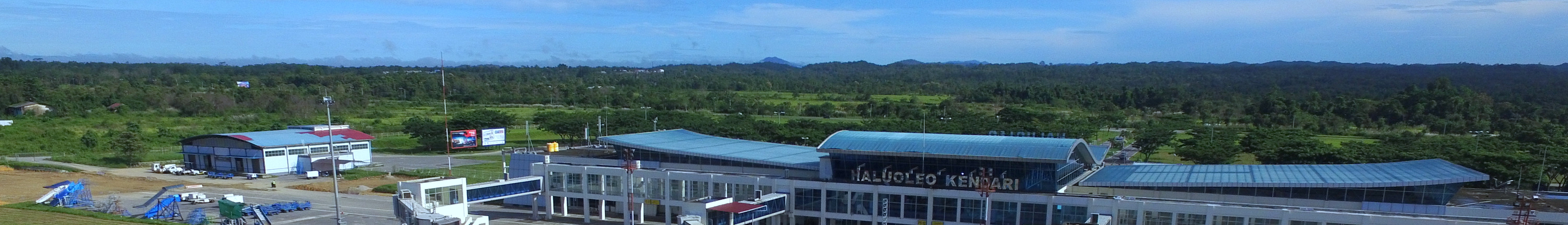
English: Haluoleo Airport, Kendari, Southeast Sulawesi, Indonesia |
|||
Date | ||||
Source | http://www.haluoleo-airport.com/gallery/page/3 | |||
Author | Haluoleo Airport - Owned by Indonesian Ministry of Transportation | |||
Other versions |
|
Licensing[edit]
Public domainPublic domainfalsefalse |
This file is in the public domain in Indonesia, because it is published and distributed by the Government of Republic of Indonesia, according to Article 43 of Law 28 of 2014 on copyrights.
There shall be no infringement of Copyright for:
العربية ∙ Basa Bali ∙ English ∙ Bahasa Indonesia ∙ 日本語 ∙ Jawa ∙ Minangkabau ∙ македонски ∙ português ∙ русский ∙ Sunda ∙ 简体中文 ∙ 繁體中文 ∙ +/− |
File history
Click on a date/time to view the file as it appeared at that time.
Date/Time | Thumbnail | Dimensions | User | Comment | |
---|---|---|---|---|---|
current | 12:47, 26 June 2018 | 3,000 × 431 (491 KB) | ErwinFCG (talk | contribs) | File:Org 5fff78e772a32f3b 1461888567000-002.jpg cropped 81 % vertically using CropTool with lossless mode. |
You cannot overwrite this file.
File usage on Commons
The following 2 pages use this file:
File usage on other wikis
The following other wikis use this file:
- Usage on en.wikivoyage.org
- Usage on eo.wikipedia.org
- Usage on incubator.wikimedia.org
- Usage on pl.wikivoyage.org
- Usage on www.wikidata.org
Metadata
This file contains additional information such as Exif metadata which may have been added by the digital camera, scanner, or software program used to create or digitize it. If the file has been modified from its original state, some details such as the timestamp may not fully reflect those of the original file. The timestamp is only as accurate as the clock in the camera, and it may be completely wrong.
Image title | DCIM\100MEDIA\DJI_0096.JPG |
---|---|
Camera manufacturer | DJI |
Camera model | FC300XW |
Author | Picasa |
Exposure time | 193/500,000 sec (0.000386) |
F-number | f/2.8 |
ISO speed rating | 100 |
Date and time of data generation | 08:09, 29 April 2016 |
Lens focal length | 3.61 mm |
Latitude | 0° 0′ 0″ N |
Longitude | 0° 0′ 0″ E |
Altitude | 66.45 meters above sea level |
Horizontal resolution | 72 dpi |
Vertical resolution | 72 dpi |
Software used | v01.01.4553 |
File change date and time | 10:41, 20 May 2016 |
Y and C positioning | Centered |
Exposure Program | Normal program |
Exif version | 2.3 |
Date and time of digitizing | 08:09, 29 April 2016 |
Meaning of each component |
|
Image compression mode | 3.5316873333333 |
APEX aperture | 2 |
APEX exposure bias | −0.65625 |
Maximum land aperture | 2 APEX (f/2) |
Subject distance | 0 meters |
Metering mode | Center weighted average |
Light source | Unknown |
Flash | Flash did not fire, No flash function |
Supported Flashpix version | 0.1 |
Color space | sRGB |
File source | Digital still camera |
Scene type | 0 |
Custom image processing | Normal process |
Exposure mode | Auto exposure |
White balance | Auto white balance |
Focal length in 35 mm film | 20 mm |
Scene capture type | Standard |
Scene control | None |
Contrast | Normal |
Saturation | Normal |
Sharpness | Normal |
Subject distance range | Unknown |
Unique image ID | fc0c4c38429ceb2235a2156ea3674e30 |
GPS tag version | 0.0.2.3 |
IIM version | 4 |