File:DETAILED VIEW OF CEILING AND ROOF JOISTS AT SILL PLATE - Daniel Winter House, Goodrich, Sheridan County, ND HABS ND,42-GORI.V,1-8.tif
Jump to navigation
Jump to search

Size of this JPG preview of this TIF file: 476 × 600 pixels. Other resolutions: 190 × 240 pixels | 381 × 480 pixels | 610 × 768 pixels | 813 × 1,024 pixels | 1,626 × 2,048 pixels | 3,969 × 5,000 pixels.
Original file (3,969 × 5,000 pixels, file size: 18.93 MB, MIME type: image/tiff)
Captions
Captions
Add a one-line explanation of what this file represents
Summary[edit]
| DETAILED VIEW OF CEILING AND ROOF JOISTS AT SILL PLATE - Daniel Winter House, Goodrich, Sheridan County, ND | ||||
|---|---|---|---|---|
| Photographer |
Related names:
|
|||
| Title |
DETAILED VIEW OF CEILING AND ROOF JOISTS AT SILL PLATE - Daniel Winter House, Goodrich, Sheridan County, ND |
|||
| Depicted place | North Dakota; Sheridan County; Goodrich | |||
| Date | Documentation compiled after 1933 | |||
| Dimensions | height: 5 in (12.7 cm); width: 4 in (10.1 cm) | |||
| Current location |
Library of Congress Prints and Photographs Division Washington, D.C. 20540 USA http://hdl.loc.gov/loc.pnp/pp.print |
|||
| Accession number |
HABS ND,42-GORI.V,1-8 |
|||
| Credit line |
|
|||
| Notes |
|
|||
| Source | https://www.loc.gov/pictures/item/nd0020.photos.103155p | |||
| Permission (Reusing this file) |
|
|||

| Object location | | View this and other nearby images on: OpenStreetMap |
|---|
File history
Click on a date/time to view the file as it appeared at that time.
| Date/Time | Thumbnail | Dimensions | User | Comment | |
|---|---|---|---|---|---|
| current | 00:45, 29 July 2014 | 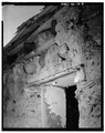 | 3,969 × 5,000 (18.93 MB) | Fæ (talk | contribs) | GWToolset: Creating mediafile for Fæ. HABS 24 July 2014 (2001:2300) |
You cannot overwrite this file.
File usage on Commons
The following page uses this file: