File:DETAIL OF UNDERSIDE OF ARCHES AT EAST END. - Soldiers' and Sailors' Memorial Bridge, Spanning Paxton Creek and Cameron Street (State Route 230) at State Street (State Route 3014 HAER PA,22-HARBU,28-12.tif
Jump to navigation
Jump to search

Size of this JPG preview of this TIF file: 485 × 599 pixels. Other resolutions: 194 × 240 pixels | 388 × 480 pixels | 621 × 768 pixels | 829 × 1,024 pixels | 1,657 × 2,048 pixels | 4,046 × 5,000 pixels.
Original file (4,046 × 5,000 pixels, file size: 19.3 MB, MIME type: image/tiff)
Captions
Captions
Add a one-line explanation of what this file represents
Summary[edit]
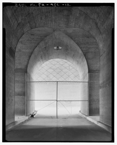
| DETAIL OF UNDERSIDE OF ARCHES AT EAST END. - Soldiers' and Sailors' Memorial Bridge, Spanning Paxton Creek and Cameron Street (State Route 230) at State Street (State Route 3014), Harrisburg, Dauphin County, PA | ||||
|---|---|---|---|---|
| Photographer |
Eliott, Joseph |
|||
| Title |
DETAIL OF UNDERSIDE OF ARCHES AT EAST END. - Soldiers' and Sailors' Memorial Bridge, Spanning Paxton Creek and Cameron Street (State Route 230) at State Street (State Route 3014), Harrisburg, Dauphin County, PA |
|||
| Description |
Gehron, William; Ross, Sidney F; Brunner, Arnold W; Strayer, Charles C; James McGraw Company; Greiner, John E; Nissley, J Richard; Pennsylvania Department of General Services; City of Harrisburg; Brussart, Albert G; Lawrie, Lee; DeLony, Eric N, project manager; Pennsylvania Department of Transportation, sponsor; Pennsylvania Historical and Museum Commission, sponsor; Elliott, Joseph E, B, photographer; Semmer, Blythe, historian |
|||
| Depicted place | Pennsylvania; Dauphin County; Harrisburg | |||
| Date | 1997 | |||
| Dimensions | 4 x 5 in. | |||
| Current location |
Library of Congress Prints and Photographs Division Washington, D.C. 20540 USA http://hdl.loc.gov/loc.pnp/pp.print |
|||
| Accession number |
HAER PA,22-HARBU,28-12 |
|||
| Credit line |
|
|||
| Notes |
|
|||
| References |
|
|||
| Source | https://www.loc.gov/pictures/item/pa3574.photos.361110p | |||
| Permission (Reusing this file) |
|
|||

| Object location | | View this and other nearby images on: OpenStreetMap |
|---|
File history
Click on a date/time to view the file as it appeared at that time.
| Date/Time | Thumbnail | Dimensions | User | Comment | |
|---|---|---|---|---|---|
| current | 03:51, 1 August 2014 |  | 4,046 × 5,000 (19.3 MB) | Fæ (talk | contribs) | GWToolset: Creating mediafile for Fæ. HABS 31 July 2014 (3000:3200) |
You cannot overwrite this file.
File usage on Commons
The following page uses this file: