File:DETAIL VIEW OF UNDERSIDE OF ARCH - Cedar Creek Bridge, Spanning Cedar Creek adjacent to State Highway 154, Morrilton, Conway County, AR HAER ARK,15-PEJESP,1-6.tif
Jump to navigation
Jump to search

Size of this JPG preview of this TIF file: 481 × 600 pixels. Other resolutions: 192 × 240 pixels | 385 × 480 pixels | 616 × 768 pixels | 821 × 1,024 pixels | 1,643 × 2,048 pixels | 4,011 × 5,000 pixels.
Original file (4,011 × 5,000 pixels, file size: 19.13 MB, MIME type: image/tiff)
Captions
Captions
Add a one-line explanation of what this file represents
Summary[edit]
| DETAIL VIEW OF UNDERSIDE OF ARCH - Cedar Creek Bridge, Spanning Cedar Creek adjacent to State Highway 154, Morrilton, Conway County, AR | ||||
|---|---|---|---|---|
| Photographer |
Taft, Louise T. Related names:
|
|||
| Title |
DETAIL VIEW OF UNDERSIDE OF ARCH - Cedar Creek Bridge, Spanning Cedar Creek adjacent to State Highway 154, Morrilton, Conway County, AR |
|||
| Depicted place | Arkansas; Conway County; Morrilton | |||
| Date | 1988 | |||
| Dimensions | 4 x 5 in. | |||
| Current location |
Library of Congress Prints and Photographs Division Washington, D.C. 20540 USA http://hdl.loc.gov/loc.pnp/pp.print |
|||
| Accession number |
HAER ARK,15-PEJESP,1-6 |
|||
| Credit line |
|
|||
| Notes |
|
|||
| Source | https://www.loc.gov/pictures/item/ar0089.photos.009883p | |||
| Permission (Reusing this file) |
|
|||

| Object location | | View this and other nearby images on: OpenStreetMap |
|---|
File history
Click on a date/time to view the file as it appeared at that time.
| Date/Time | Thumbnail | Dimensions | User | Comment | |
|---|---|---|---|---|---|
| current | 11:34, 27 June 2014 | 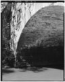 | 4,011 × 5,000 (19.13 MB) | Fæ (talk | contribs) | GWToolset: Creating mediafile for Fæ. HABS batch upload 26 June 2014 (151:200) |
You cannot overwrite this file.
File usage on Commons
The following page uses this file: