File:Da Ming yu di tu LOC 2002626776-1.tif
Jump to navigation
Jump to search

Size of this JPG preview of this TIF file: 640 × 600 pixels. Other resolutions: 256 × 240 pixels | 820 × 768 pixels | 1,093 × 1,024 pixels | 2,186 × 2,048 pixels | 9,658 × 9,049 pixels.
Original file (9,658 × 9,049 pixels, file size: 250.04 MB, MIME type: image/tiff)
Captions
Captions
Add a one-line explanation of what this file represents
Summary[edit]
| Warning | The original file is very high-resolution. It might not load properly or could cause your browser to freeze when opened at full size. |
|---|
| Description |
English: The "General Map of the Lands" (Yudi Zongtu) from the Atlas of the Ming Empire (Daming Yuditu) compiled in the 1540s and 1550s during the Jianjing Era (嘉靖) of the Ming dynasty. Covers Beizhili (now Beijing, Tianjin, and Hebei), Henan, Nanzhili (now Shanghai, Anhui, and Jiangsu), Shandong (then including modern Liaoning), Shanxi, Shaanxi (then including modern Ningxia and Gansu), Sichuan (then including modern Chongqing), Guangdong (then including modern Hong Kong, Macao, and Hainan), Guangxi, Fujian (then notionally including Taiwan but left unpictured), Zhejiang, Huguang (now Hubei and Hunan), Jiangxi, Yunnan, and Guizhou. Yellow River presented Golden, Yangtze River presented blue. Great Wall omitted but the Gobi Desert is presented as a natural northern barrier. Beijing prime meridian. Each square represents 500 li (里, around ⅓ km), misunderstood by the LOC as "miles" (around 1⅔ km). LOC copy provided by Langdon Warner 1929 (#10), misrepresented as the work's creator. Copious damage. Previous call number: G2305 .D3 1566 Vault Shelf. Note on back of LOC copy includes the date "1668".
中文:輿地總圖, 舆地总图, Yudi Zongtu, Yü-ti Tsung-t'u. 在后面,有"康熙按七年五月初上納,南陽县监". |
||
| Title | English: General Map
中文:輿地總圖, Yudi Zongtu. |
||
| Shelf ID | G2305 .D3 1559 | ||
| Parent | https://www.loc.gov/resource/g7820m.gct00125/ | ||
| Date | |||
| Source | LOC | ||
| Author | Omitted | ||
| Permission (Reusing this file) |
|
||
| Other versions |
|
||
| Location | China | ||
| Part of | American Memory · General Maps · Catalog · Geography And Map Division | ||
| Subject | Maps, Manuscript · Early Works To 1800 · China |


Licensing[edit]
|
This is a faithful photographic reproduction of a two-dimensional, public domain work of art. The work of art itself is in the public domain for the following reason:
The official position taken by the Wikimedia Foundation is that "faithful reproductions of two-dimensional public domain works of art are public domain".
This photographic reproduction is therefore also considered to be in the public domain in the United States. In other jurisdictions, re-use of this content may be restricted; see Reuse of PD-Art photographs for details. | ||||
File history
Click on a date/time to view the file as it appeared at that time.
| Date/Time | Thumbnail | Dimensions | User | Comment | |
|---|---|---|---|---|---|
| current | 01:34, 5 June 2018 | 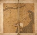 | 9,658 × 9,049 (250.04 MB) | Fæ (talk | contribs) | LOC Maps multisheet https://www.loc.gov/item/2002626776/ sheet 1 of 19 #2041 |
You cannot overwrite this file.
File usage on Commons
The following page uses this file: