File:Der Jesuiten-Atlas der Kanghsi-Zeit - China und die Aussenlaender LOC 74650033-16.tif
Jump to navigation
Jump to search
Size of this JPG preview of this TIF file: 621 × 600 pixels. Other resolutions: 249 × 240 pixels | 497 × 480 pixels | 795 × 768 pixels | 1,060 × 1,024 pixels | 2,121 × 2,048 pixels | 6,288 × 6,072 pixels.
Original file (6,288 × 6,072 pixels, file size: 109.24 MB, MIME type: image/tiff)
Captions
Captions
Add a one-line explanation of what this file represents
Summary[edit]
| Description |
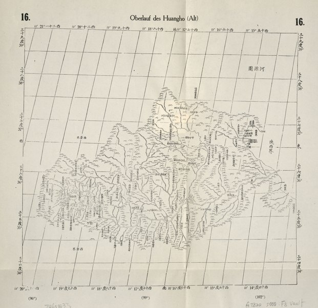
English: The Map of the Origin of the Yellow River under the Qing Empire, the Amdo Tibetan area, now eastern Qinghai and southwestern Gansu, from the LOC copy of the 1941 Fuchs edition of the 1721 woodcut edition of the Kangxi Atlas. Inexplicable repeat of Map 9 of the same area with different information, presumably corrections from later surveys of northern Tibet. Spurs of the Great Wall depicted on the east side. Adjacent territories left blank. Beijing and Greenwich prime meridians. Misidentified by the LOC as both the 1941 and 1943 edition. Prev. call number: G2305.1721 .F8 1943 Vault Shelf.
Deutsch: Oberlauf des Huangho (Alt)
中文:黃河源和青海圖 |
||
| Title | English: The Jesuit Atlas of the Kangxi Era
中文:《皇輿全覽圖》,《皇舆全览图》,Huángyú Quánlǎntú,Huang-yü Ch'üan-lan-t'u
Deutsch: Der Jesuiten-Atlas der Kanghsi-Zeit |
||
| Shelf ID | G7820 s000 .R4 | ||
| Parent | LOC | ||
| Sheet title | English: 16. Map of the Origin of the Yellow River
Deutsch: 16. Oberlauf des Huangho (Alt)
中文:《河源圖》,《河源图》,Héyuán Tú,Ho-yüan T'u |
||
| Date |
English: 1941, from 1721 originals, from maps drafted 1708–1718, from surveys carried out 1708–1717
中文:康熙四十七年到康熙六十年 |
||
| Source | LOC | ||
| Author | Compiled by Chinese and Jesuits under the Kangxi Emperor, edited by Walter Fuchs | ||
| Permission (Reusing this file) |
|
||
| Other versions |
|
||
| Location | China | ||
| Part of | American Memory · General Maps · Catalog · Geography And Map Division | ||
| Subject | Maps · Early Works To 1800 · China · Names, Geographical · Facsimiles |


Licensing[edit]
This work is in the public domain in the United States because it is a work prepared by an officer or employee of the United States Government as part of that person’s official duties under the terms of Title 17, Chapter 1, Section 105 of the US Code.
Note: This only applies to original works of the Federal Government and not to the work of any individual U.S. state, territory, commonwealth, county, municipality, or any other subdivision. This template also does not apply to postage stamp designs published by the United States Postal Service since 1978. (See § 313.6(C)(1) of Compendium of U.S. Copyright Office Practices). It also does not apply to certain US coins; see The US Mint Terms of Use.
|
 | |
| This file has been identified as being free of known restrictions under copyright law, including all related and neighboring rights. | ||
File history
Click on a date/time to view the file as it appeared at that time.
| Date/Time | Thumbnail | Dimensions | User | Comment | |
|---|---|---|---|---|---|
| current | 20:31, 11 July 2018 |  | 6,288 × 6,072 (109.24 MB) | Fæ (talk | contribs) | LOC Maps multisheet https://www.loc.gov/item/74650033/ sheet 16 of 35 #51 |
You cannot overwrite this file.
File usage on Commons
The following 3 pages use this file: