File:Drawing entitled "Sketch of proposed site for Pine Hills Patrol Station, Cleveland National Forest, San Diego County, California. Surveyed by Norman McClean, U.S.F.S., HABS CAL,37-JUL.V,1A-10.tif
Jump to navigation
Jump to search

Size of this JPG preview of this TIF file: 492 × 600 pixels. Other resolutions: 197 × 240 pixels | 394 × 480 pixels | 630 × 768 pixels | 840 × 1,024 pixels | 1,679 × 2,048 pixels | 4,100 × 5,000 pixels.
Original file (4,100 × 5,000 pixels, file size: 19.55 MB, MIME type: image/tiff)
Captions
Captions
Add a one-line explanation of what this file represents
Summary[edit]
| Photographer |
Related names:
|
|||
| Title |
Drawing entitled "Sketch of proposed site for Pine Hills Patrol Station, Cleveland National Forest, San Diego County, California. Surveyed by Norman McClean, U.S.F.S., January, 1934. - Pine Hills Station, Barracks, West Side of Boulder Creek Road at Engineers Road, Julian, San Diego County, CA |
|||
| Depicted place | California; San Diego County; Julian | |||
| Date | Documentation compiled after 1933 | |||
| Dimensions | 4 x 5 in. | |||
| Current location |
Library of Congress Prints and Photographs Division Washington, D.C. 20540 USA http://hdl.loc.gov/loc.pnp/pp.print |
|||
| Accession number |
HABS CAL,37-JUL.V,1A-10 |
|||
| Credit line |
|
|||
| Notes |
|
|||
| Source | https://www.loc.gov/pictures/item/ca3062.photos.376858p | |||
| Permission (Reusing this file) |
|

| Object location | | View this and other nearby images on: OpenStreetMap |
|---|
File history
Click on a date/time to view the file as it appeared at that time.
| Date/Time | Thumbnail | Dimensions | User | Comment | |
|---|---|---|---|---|---|
| current | 05:20, 6 July 2014 | 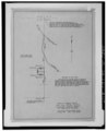 | 4,100 × 5,000 (19.55 MB) | Fæ (talk | contribs) | GWToolset: Creating mediafile for Fæ. HABS 05 July 2014 (501:600) |
You cannot overwrite this file.
File usage on Commons
The following page uses this file: