File:ENTRANCE TO THE FEEDER, TAKEN WHEN THE CANAL SYSTEM WAS DRAINED- W. Richard Ansteth, Photographer 1975 - Moody Street Feeder, Moody Street vicinity, Lowell, Middlesex County, MA HAER MASS,9-LOW,16-1.tif
Jump to navigation
Jump to search

Size of this JPG preview of this TIF file: 744 × 600 pixels. Other resolutions: 298 × 240 pixels | 596 × 480 pixels | 953 × 768 pixels | 1,270 × 1,024 pixels | 2,540 × 2,048 pixels | 5,000 × 4,031 pixels.
Original file (5,000 × 4,031 pixels, file size: 19.22 MB, MIME type: image/tiff)
Captions
Captions
Add a one-line explanation of what this file represents
Summary[edit]
| ENTRANCE TO THE FEEDER, TAKEN WHEN THE CANAL SYSTEM WAS DRAINED- W. Richard Ansteth, Photographer 1975 - Moody Street Feeder, Moody Street vicinity, Lowell, Middlesex County, MA | ||||
|---|---|---|---|---|
| Title |
ENTRANCE TO THE FEEDER, TAKEN WHEN THE CANAL SYSTEM WAS DRAINED- W. Richard Ansteth, Photographer 1975 - Moody Street Feeder, Moody Street vicinity, Lowell, Middlesex County, MA |
|||
| Description |
Proprietors of the Locks and Canals on the Merrimack River; Boott Manufacturing Company; Hawley, Monica E, transmitter; Ansteth, W Richard, photographer; Malone, Patrick M, historian |
|||
| Depicted place | Massachusetts; Middlesex County; Lowell | |||
| Date | Documentation compiled after 1968 | |||
| Dimensions | 4 x 5 in. | |||
| Current location |
Library of Congress Prints and Photographs Division Washington, D.C. 20540 USA http://hdl.loc.gov/loc.pnp/pp.print |
|||
| Accession number |
HAER MASS,9-LOW,16-1 |
|||
| Credit line |
|
|||
| Notes |
|
|||
| Source | https://www.loc.gov/pictures/item/ma0546.photos.080586p | |||
| Permission (Reusing this file) |
|
|||

| Object location | | View this and other nearby images on: OpenStreetMap |
|---|
File history
Click on a date/time to view the file as it appeared at that time.
| Date/Time | Thumbnail | Dimensions | User | Comment | |
|---|---|---|---|---|---|
| current | 23:18, 20 July 2014 | 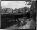 | 5,000 × 4,031 (19.22 MB) | Fæ (talk | contribs) | GWToolset: Creating mediafile for Fæ. HABS 20 July 2014 (1401:1600) |
You cannot overwrite this file.
File usage on Commons
The following 2 pages use this file:
File usage on other wikis
The following other wikis use this file:
- Usage on de.wikipedia.org
- Usage on www.wikidata.org