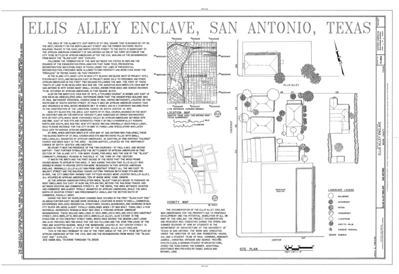
File:Ellis Alley Enclave, 200 blocks of Ellis Alley and Chestnut and Center Streets, San Antonio, Bexar County, TX HABS TEX,15-SANT,58- (sheet 1 of 1).tif
Jump to navigation
Jump to search
Size of this JPG preview of this TIF file: 800 × 549 pixels. Other resolutions: 320 × 220 pixels | 640 × 439 pixels | 1,024 × 703 pixels | 1,280 × 879 pixels | 2,560 × 1,757 pixels | 14,451 × 9,920 pixels.
Original file (14,451 × 9,920 pixels, file size: 732 KB, MIME type: image/tiff)
Captions
Captions
Add a one-line explanation of what this file represents
Summary[edit]
| Warning | The original file is very high-resolution. It might not load properly or could cause your browser to freeze when opened at full size. |
|---|
| HABS TEX,15-SANT,58- (sheet 1 of 1) - Ellis Alley Enclave, 200 blocks of Ellis Alley and Chestnut and Center Streets, San Antonio, Bexar County, TX | ||||
|---|---|---|---|---|
| Title |
HABS TEX,15-SANT,58- (sheet 1 of 1) - Ellis Alley Enclave, 200 blocks of Ellis Alley and Chestnut and Center Streets, San Antonio, Bexar County, TX |
|||
| Depicted place | Texas; Bexar County; San Antonio | |||
| Date | Documentation compiled after 1933 | |||
| Dimensions | 24 x 36 in. (D size) | |||
| Current location |
Library of Congress Prints and Photographs Division Washington, D.C. 20540 USA http://hdl.loc.gov/loc.pnp/pp.print |
|||
| Accession number |
HABS TEX,15-SANT,58- (sheet 1 of 1) |
|||
| Credit line |
|
|||
| Notes |
|
|||
| Source | https://www.loc.gov/pictures/item/tx0981.sheet.00001a | |||
| Permission (Reusing this file) |
|
|||
| Other versions |
.png) |
|||

File history
Click on a date/time to view the file as it appeared at that time.
| Date/Time | Thumbnail | Dimensions | User | Comment | |
|---|---|---|---|---|---|
| current | 09:59, 2 August 2014 |  | 14,451 × 9,920 (732 KB) | Fæ (talk | contribs) | GWToolset: Creating mediafile for Fæ. HABS 2014-08-01 (3201:3400) |
You cannot overwrite this file.
File usage on Commons
The following page uses this file: