File:FIRST FLOOR, NORTHEAST ROOM, VIEW OF STAIR TO SECOND FLOOR - Chesapeake and Ohio Canal, Lock Tender's House, Lock 37, 67.0 miles above tidewater, Antietam, Washington County, MD HABS MD,22-ANTI.V,6-2.tif
Jump to navigation
Jump to search

Size of this JPG preview of this TIF file: 800 × 573 pixels. Other resolutions: 320 × 229 pixels | 640 × 458 pixels | 1,024 × 733 pixels | 1,280 × 916 pixels | 2,560 × 1,833 pixels | 5,000 × 3,580 pixels.
Original file (5,000 × 3,580 pixels, file size: 17.07 MB, MIME type: image/tiff)
Captions
Captions
Add a one-line explanation of what this file represents
Summary[edit]
| FIRST FLOOR, NORTHEAST ROOM, VIEW OF STAIR TO SECOND FLOOR - Chesapeake and Ohio Canal, Lock Tender's House, Lock 37, 67.0 miles above tidewater, Antietam, Washington County, MD | ||||
|---|---|---|---|---|
| Title |
FIRST FLOOR, NORTHEAST ROOM, VIEW OF STAIR TO SECOND FLOOR - Chesapeake and Ohio Canal, Lock Tender's House, Lock 37, 67.0 miles above tidewater, Antietam, Washington County, MD |
|||
| Description |
Keune, Russel V, project manager; Boucher, Jack E, photographer; Bobrow, Michael L, delineator; Hanna, John H, delineator; Harris, William T, delineator; Wormuth, C Gustave, delineator; McDonald, Alan, delineator |
|||
| Depicted place | Maryland; Washington County; Antietam | |||
| Date | Documentation compiled after 1933 | |||
| Dimensions | 5 x 7 in. | |||
| Current location |
Library of Congress Prints and Photographs Division Washington, D.C. 20540 USA http://hdl.loc.gov/loc.pnp/pp.print |
|||
| Accession number |
HABS MD,22-ANTI.V,6-2 |
|||
| Credit line |
|
|||
| Notes |
|
|||
| Source | https://www.loc.gov/pictures/item/md0592.photos.084938p | |||
| Permission (Reusing this file) |
|
|||

| Object location | | View this and other nearby images on: OpenStreetMap |
|---|
File history
Click on a date/time to view the file as it appeared at that time.
| Date/Time | Thumbnail | Dimensions | User | Comment | |
|---|---|---|---|---|---|
| current | 02:58, 22 July 2014 | 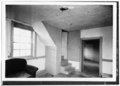 | 5,000 × 3,580 (17.07 MB) | Fæ (talk | contribs) | GWToolset: Creating mediafile for Fæ. HABS 21 July 2014 (1601:1800) |
You cannot overwrite this file.
File usage on Commons
The following page uses this file: