File:First floor, looking south. - Agnews State Hospital, Laundry, Avenue A between Second and Third Streets, Santa Clara, Santa Clara County, CA HABS CAL,43-SANCLA,6BA-4.tif
Jump to navigation
Jump to search

Size of this JPG preview of this TIF file: 800 × 572 pixels. Other resolutions: 320 × 229 pixels | 640 × 457 pixels | 1,024 × 732 pixels | 1,280 × 914 pixels | 2,560 × 1,829 pixels | 5,000 × 3,572 pixels.
Original file (5,000 × 3,572 pixels, file size: 17.04 MB, MIME type: image/tiff)
Captions
Captions
Add a one-line explanation of what this file represents
Summary[edit]
| First floor, looking south. - Agnews State Hospital, Laundry, Avenue A between Second and Third Streets, Santa Clara, Santa Clara County, CA | ||||
|---|---|---|---|---|
| Photographer |
Porter, William Related names:
|
|||
| Title |
First floor, looking south. - Agnews State Hospital, Laundry, Avenue A between Second and Third Streets, Santa Clara, Santa Clara County, CA |
|||
| Depicted place | California; Santa Clara County; Santa Clara | |||
| Date | 1998 | |||
| Dimensions | 5 x 7 in. | |||
| Current location |
Library of Congress Prints and Photographs Division Washington, D.C. 20540 USA http://hdl.loc.gov/loc.pnp/pp.print |
|||
| Accession number |
HABS CAL,43-SANCLA,6BA-4 |
|||
| Credit line |
|
|||
| Notes |
|
|||
| Source | https://www.loc.gov/pictures/item/ca2874.photos.377458p | |||
| Permission (Reusing this file) |
|
|||

| Object location | | View this and other nearby images on: OpenStreetMap |
|---|
File history
Click on a date/time to view the file as it appeared at that time.
| Date/Time | Thumbnail | Dimensions | User | Comment | |
|---|---|---|---|---|---|
| current | 23:06, 7 July 2014 | 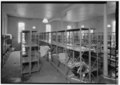 | 5,000 × 3,572 (17.04 MB) | Fæ (talk | contribs) | GWToolset: Creating mediafile for Fæ. HABS 05 July 2014 (401:500) |
You cannot overwrite this file.
File usage on Commons
The following page uses this file: