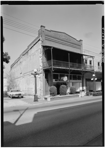
File:GENERAL VIEW FROM SOUTHWEST - B. F. Marcos Building, 1610 East Seventh Avenue, Tampa, Hillsborough County, FL HABS FLA,29-TAMP,13-2.tif
Jump to navigation
Jump to search
Size of this JPG preview of this TIF file: 427 × 599 pixels. Other resolutions: 171 × 240 pixels | 342 × 480 pixels | 547 × 768 pixels | 730 × 1,024 pixels | 1,460 × 2,048 pixels | 3,565 × 5,000 pixels.
Original file (3,565 × 5,000 pixels, file size: 17 MB, MIME type: image/tiff)
Captions
Captions
Add a one-line explanation of what this file represents
Summary[edit]
| GENERAL VIEW FROM SOUTHWEST - B. F. Marcos Building, 1610 East Seventh Avenue, Tampa, Hillsborough County, FL | ||||
|---|---|---|---|---|
| Photographer |
Related names:
|
|||
| Title |
GENERAL VIEW FROM SOUTHWEST - B. F. Marcos Building, 1610 East Seventh Avenue, Tampa, Hillsborough County, FL |
|||
| Depicted place | Florida; Hillsborough County; Tampa | |||
| Date | Documentation compiled after 1933 | |||
| Dimensions | 5 x 7 in. | |||
| Current location |
Library of Congress Prints and Photographs Division Washington, D.C. 20540 USA http://hdl.loc.gov/loc.pnp/pp.print |
|||
| Accession number |
HABS FLA,29-TAMP,13-2 |
|||
| Credit line |
|
|||
| Notes |
|
|||
| References |
|
|||
| Source | https://www.loc.gov/pictures/item/fl0113.photos.052705p | |||
| Permission (Reusing this file) |
|
|||

| Camera location | | View this and other nearby images on: OpenStreetMap |
|---|
File history
Click on a date/time to view the file as it appeared at that time.
| Date/Time | Thumbnail | Dimensions | User | Comment | |
|---|---|---|---|---|---|
| current | 08:40, 11 July 2014 |  | 3,565 × 5,000 (17 MB) | Fæ (talk | contribs) | GWToolset: Creating mediafile for Fæ. HABS 09 July 2014 (801:1000) |
You cannot overwrite this file.
File usage on Commons
The following page uses this file: