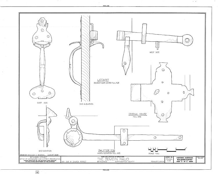
File:Gemein Haus, 62-66 West Church Street, Bethlehem, Northampton County, PA HABS PA,48-BETH,3-A- (sheet 8 of 10).tif
Jump to navigation
Jump to search
Size of this JPG preview of this TIF file: 762 × 600 pixels. Other resolutions: 305 × 240 pixels | 610 × 480 pixels | 976 × 768 pixels | 1,280 × 1,008 pixels | 2,560 × 2,015 pixels | 9,634 × 7,584 pixels.
Original file (9,634 × 7,584 pixels, file size: 513 KB, MIME type: image/tiff)
Captions
Captions
Add a one-line explanation of what this file represents
Summary[edit]
| HABS PA,48-BETH,3-A- (sheet 8 of 10) - Gemein Haus, 62-66 West Church Street, Bethlehem, Northampton County, PA | ||||
|---|---|---|---|---|
| Title |
HABS PA,48-BETH,3-A- (sheet 8 of 10) - Gemein Haus, 62-66 West Church Street, Bethlehem, Northampton County, PA |
|||
| Depicted place | Pennsylvania; Northampton County; Bethlehem | |||
| Date | Documentation compiled after 1933 | |||
| Dimensions | 19 x 24 in. (B size) | |||
| Current location |
Library of Congress Prints and Photographs Division Washington, D.C. 20540 USA http://hdl.loc.gov/loc.pnp/pp.print |
|||
| Accession number |
HABS PA,48-BETH,3-A- (sheet 8 of 10) |
|||
| Credit line |
|
|||
| Notes |
|
|||
| Source | https://www.loc.gov/pictures/item/pa0644.sheet.00008a | |||
| Permission (Reusing this file) |
|
|||
| Other versions |
.png) .png) .png) .png) .png) .png) .png) .png) .png) .png) |
|||

| Object location | | View this and other nearby images on: OpenStreetMap |
|---|
File history
Click on a date/time to view the file as it appeared at that time.
| Date/Time | Thumbnail | Dimensions | User | Comment | |
|---|---|---|---|---|---|
| current | 23:25, 2 August 2014 |  | 9,634 × 7,584 (513 KB) | Fæ (talk | contribs) | GWToolset: Creating mediafile for Fæ. HABS 2014-08-01 2601-2900 missing |
You cannot overwrite this file.
File usage on Commons
The following page uses this file: