File:Genticore plate, Upper Canada.png

Original file (1,280 × 800 pixels, file size: 1.27 MB, MIME type: image/png)
Captions
Captions
Summary[edit]
| Description |
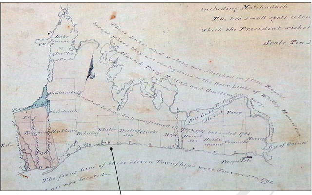
English: Genticore plate. From west to east, and north to south, are depicted thw townships of York, Vaughan, King, Scarborough, Markham, Whitchurch, Gwillimbury, Pickering, Whitby, Darlington, Clarke, Hope, Hamilton, Haldimand, Cramahe, and Murray. Demarcated at left is the 'Purchase of Toronto in 1787'. Also shown are Bay of Quinte and Lake Simcoe, with its older name Lac Clie. |
| Date | between 1790 and 1799 |
| Source | https://www.whitby.ca/en/resources/pl-misc_culturalheritageresourcesurvey.pdf#page=70 |
| Author | Unknown author |
Licensing[edit]
This Canadian work is in the public domain in Canada because its copyright has expired due to one of the following:
it was not subject to Crown copyright, and
|
 |
File history
Click on a date/time to view the file as it appeared at that time.
| Date/Time | Thumbnail | Dimensions | User | Comment | |
|---|---|---|---|---|---|
| current | 18:00, 17 May 2020 | | 1,280 × 800 (1.27 MB) | SteinsplitterBot (talk | contribs) | Bot: Image rotated by 90° |
| 16:03, 17 May 2020 |  | 800 × 1,280 (1.3 MB) | Geo Swan (talk | contribs) | Reverted to version as of 15:58, 17 May 2020 (UTC) | |
| 16:01, 17 May 2020 |  | 457 × 761 (512 KB) | Geo Swan (talk | contribs) | Cropped 67 % horizontally, 1 % vertically using CropTool with precise mode. | |
| 16:00, 17 May 2020 |  | 1,366 × 768 (613 KB) | Geo Swan (talk | contribs) | Reverted to version as of 15:55, 17 May 2020 (UTC) | |
| 15:58, 17 May 2020 |  | 800 × 1,280 (1.3 MB) | Geo Swan (talk | contribs) | another resolution | |
| 15:55, 17 May 2020 |  | 1,366 × 768 (613 KB) | Geo Swan (talk | contribs) | == {{int:filedesc}} == {{Information |Description=Genticore plate |Source=https://www.whitby.ca/en/resources/pl-misc_culturalheritageresourcesurvey.pdf#page=70 |Date=unknown |Author=unknown |Permission={{PD-Canada}} |other_versions= }} Category:1910 in Ontario Category:Devil’s Den Bridge Category:Canadian Northern Rail Line Category:Old maps of Ontario Category:Lake Ontaro |
You cannot overwrite this file.
File usage on Commons
There are no pages that use this file.