File:GeoRoute9 Ruhlaer Insel Station03a.jpg
Jump to navigation
Jump to search

Size of this preview: 696 × 599 pixels. Other resolutions: 279 × 240 pixels | 558 × 480 pixels | 892 × 768 pixels | 1,189 × 1,024 pixels | 2,379 × 2,048 pixels | 3,525 × 3,035 pixels.
Original file (3,525 × 3,035 pixels, file size: 2.59 MB, MIME type: image/jpeg)
Captions
Captions
Add a one-line explanation of what this file represents
Summary[edit]
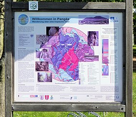
| Description | Bilderserie zu OSM-Belegmotiven aus Ruhla. Bildmotiv: Infotafel zur Tropfsteinhöhle im Ruhlaer Stadtteil Kittelsthal. Die Station 03 in Kittelsthal ist Bestandteil des Projektes Geopark Thüringen. Eine zweite Tafel dieser Station 3 befindet sich beim Höhleneingang zeigt den Verlauf der GeoRoute 9 - "Wanderung über die tropische Ruhlaer Insel", Rundroute Ruhla - UNESCO Global Geopark Thüringen Inselsberg - Drei Gleichen. Weitere Tafeln befinden sich in Ruhla, in Schweina - Altensteiner Höhle und in Bad Liebenstein. |
| Date | |
| Source | Own work |
| Author | EACC80 |
Licensing[edit]
I, the copyright holder of this work, hereby publish it under the following licenses:

|
Permission is granted to copy, distribute and/or modify this document under the terms of the GNU Free Documentation License, Version 1.2 or any later version published by the Free Software Foundation; with no Invariant Sections, no Front-Cover Texts, and no Back-Cover Texts. A copy of the license is included in the section entitled GNU Free Documentation License. |
This file is licensed under the Creative Commons Attribution 3.0 Unported license.
- You are free:
- to share – to copy, distribute and transmit the work
- to remix – to adapt the work
- Under the following conditions:
- attribution – You must give appropriate credit, provide a link to the license, and indicate if changes were made. You may do so in any reasonable manner, but not in any way that suggests the licensor endorses you or your use.
You may select the license of your choice.
|
The photographical reproduction of this work is covered under the article § 59 of the German copyright law, which states that "It shall be permissible to reproduce, by painting, drawing, photography or cinematography, works which are permanently located on public ways, streets or places and to distribute and publicly communicate such copies. For works of architecture, this provision shall be applicable only to the external appearance."
As with all other “limits of copyright by legally permitted uses”, no changes to the actual work are permitted under § 62 of the German copyright law (UrhG). See Commons:Copyright rules by territory/Germany#Freedom of panorama for more information.
|
File history
Click on a date/time to view the file as it appeared at that time.
| Date/Time | Thumbnail | Dimensions | User | Comment | |
|---|---|---|---|---|---|
| current | 11:17, 26 April 2024 | | 3,525 × 3,035 (2.59 MB) | EACC80 (talk | contribs) | == {{int:filedesc}} == {{Information |Description=Bilderserie zu OSM-Belegmotiven aus Ruhla. Bildmotiv: Infotafel zur Tropfsteinhöhle im Ruhlaer Stadtteil Kittelsthal. Die Station 03 in Kittelsthal ist Bestandteil des Projektes Geopark Thüringen. Eine zweite Tafel dieser Station 3 befindet sich beim Höhleneingang zeigt den Verlauf der GeoRoute 9 - "Wanderung über die tropische Ruhlaer Insel", Rundroute Ruhla - UNESCO Global Geopark Thüringen Inselsberg - Drei Gleichen. Weitere Tafeln befinden... |
You cannot overwrite this file.
File usage on Commons
The following page uses this file: