File:Geologic Index Map.jpg
Jump to navigation
Jump to search

Size of this preview: 265 × 600 pixels. Other resolutions: 106 × 240 pixels | 212 × 480 pixels | 339 × 768 pixels | 452 × 1,024 pixels | 1,597 × 3,614 pixels.
Original file (1,597 × 3,614 pixels, file size: 1.03 MB, MIME type: image/jpeg)
Captions
Captions
Add a one-line explanation of what this file represents


Summary[edit]
| Description |
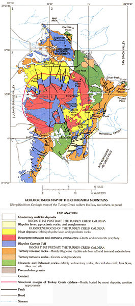
English: Geologic index map of the Chiricahua Mountains in southeast Arizona. |
| Date | |
| Source | U.S. Geological Survey, Department of the Interior, http://ngmdb.usgs.gov/Prodesc/proddesc_13028.htm |
| Author | Pallister, J.S., du Brey, E.A., and Hall, D.B. |
Licensing[edit]
This image is in the public domain in the United States because it only contains materials that originally came from the United States Geological Survey, an agency of the United States Department of the Interior. For more information, see the official USGS copyright policy.
|
File history
Click on a date/time to view the file as it appeared at that time.
| Date/Time | Thumbnail | Dimensions | User | Comment | |
|---|---|---|---|---|---|
| current | 19:30, 21 November 2013 | | 1,597 × 3,614 (1.03 MB) | Melissausburn (talk | contribs) | User created page with UploadWizard |
You cannot overwrite this file.
File usage on Commons
There are no pages that use this file.