File:GermanyMuensterWestphaliaSculptureGeschichteVonUntenPaulWulf.JPG
Jump to navigation
Jump to search

Size of this preview: 398 × 599 pixels. Other resolutions: 159 × 240 pixels | 319 × 480 pixels | 510 × 768 pixels | 680 × 1,024 pixels | 1,361 × 2,048 pixels | 3,264 × 4,912 pixels.
Original file (3,264 × 4,912 pixels, file size: 4.99 MB, MIME type: image/jpeg)
Captions
Captions
Add a one-line explanation of what this file represents
Summary
Object
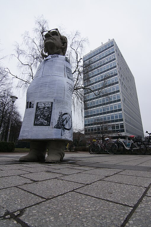
| Silke Wagner: Münster’s HISTORY FROM BELOW
|
|||||||||||||||||||||
|---|---|---|---|---|---|---|---|---|---|---|---|---|---|---|---|---|---|---|---|---|---|
| Artist |
|
 | |||||||||||||||||||
| Title |
German: Münsters GESCHICHTE VON UNTEN Münster’s HISTORY FROM BELOW |
||||||||||||||||||||
| Object type |
sculpture |
||||||||||||||||||||
| Genre |
public art |
||||||||||||||||||||
| Description |
English: The Sculpture "Münsters Geschichte von unten" by Silke Wagner. Iduna-Building by Friedrich Wilhelm Kraemer.
Deutsch: Die Skulptur "Münsters Geschichte von unten" von Silke Wagner wurde für die skulptur.projekte münster 07 geschaffen und ursprünglich vor dem Stadthaus I aufgestellt. Seit dem 5. September 2010 hat sie ihre endgültige Heimat auf dem Servatiiplatz gefunden. Architekt des Iduna-Hochhauses ist Friedrich Wilhelm Kraemer. |
||||||||||||||||||||
| Date |
2007 |
||||||||||||||||||||
| Medium |
concrete |
||||||||||||||||||||
| Dimensions |
height: 3.4 m (11.1 ft) |
||||||||||||||||||||
| Object location |
|
||||||||||||||||||||
| Exhibition history |
|
||||||||||||||||||||
| References | |||||||||||||||||||||

Photograph
| Date |
|
| Source |
Own work |
| Author |
Gerrit Elshof |
| Camera location | | View this and other nearby images on: OpenStreetMap |
|---|
Licensing
Gerrit Elshof, the copyright holder of this work, hereby publishes it under the following licenses:
This file is licensed under the Creative Commons Attribution-Share Alike 3.0 Unported license.
Attribution: Gerrit Elshof
- You are free:
- to share – to copy, distribute and transmit the work
- to remix – to adapt the work
- Under the following conditions:
- attribution – You must give appropriate credit, provide a link to the license, and indicate if changes were made. You may do so in any reasonable manner, but not in any way that suggests the licensor endorses you or your use.
- share alike – If you remix, transform, or build upon the material, you must distribute your contributions under the same or compatible license as the original.

|
Permission is granted to copy, distribute and/or modify this document under the terms of the GNU Free Documentation License, Version 1.2 or any later version published by the Free Software Foundation; with no Invariant Sections, no Front-Cover Texts, and no Back-Cover Texts. A copy of the license is included in the section entitled GNU Free Documentation License. |
You may select the license of your choice.
|
The photographical reproduction of this work is covered under the article § 59 of the German copyright law, which states that "It shall be permissible to reproduce, by painting, drawing, photography or cinematography, works which are permanently located on public ways, streets or places and to distribute and publicly communicate such copies. For works of architecture, this provision shall be applicable only to the external appearance."
As with all other “limits of copyright by legally permitted uses”, no changes to the actual work are permitted under § 62 of the German copyright law (UrhG). See Commons:Copyright rules by territory/Germany#Freedom of panorama for more information.
|
File history
Click on a date/time to view the file as it appeared at that time.
| Date/Time | Thumbnail | Dimensions | User | Comment | |
|---|---|---|---|---|---|
| current | 22:32, 1 March 2011 | | 3,264 × 4,912 (4.99 MB) | Elektroschreiber (talk | contribs) | {{Information |Description ={{en|1=The Sculpture "Münsters Geschichte von unten" by Silke Wagner}} {{de|1=Die Skulptur "Münsters Geschichte von unten" von Silke Wagner wurde für die skulptur.projekte münster 07 geschaffen und ursprünglich vor dem |
You cannot overwrite this file.
File usage on Commons
The following 4 pages use this file:
File usage on other wikis
The following other wikis use this file:
- Usage on ar.wikipedia.org
- Usage on de.wikipedia.org
- Usage on de.wikivoyage.org
- Usage on en.wikipedia.org
- Usage on mk.wikipedia.org
- Usage on www.wikidata.org